From Cycles to Risk: How Digitized, Geospatial Approaches Are Reshaping Utility Vegetation Management
Vegetation doesn’t negotiate. It grows on its own schedule, dies back in dry spells, drops limbs during storms and pushes into rights-of-way (ROW) with no regard for when a crew last came through. Yet many utility vegetation management programs are still organized around the idea that a fixed trimming cycle is enough to keep risk in check.
Roughly one in four power outages nationwide traces back to vegetation, according to research by CNUC and the University of Wisconsin–Stevens Point's College of Natural Resources. The industry spends $6 to $8 billion a year on the problem, per Accenture, and the results are becoming harder to defend. The calendar-based model that many utilities are working from wasn’t built for today’s vegetation.
The answer isn’t spending more. It’s building programs around where risk actually lives — leveraging spatial data and remote sensing, putting real-time tools in the hands of field crews and treating vegetation management less like a maintenance schedule and more like an ongoing read of conditions across the service territory.
The Regulatory and Climate Context
In April 2024, NERC’s updated FAC-003-5 Transmission Vegetation Management standard took effect, folding what had been a two-tier compliance structure into a single, broader framework. The scope of what Transmission Owners and Generator Owners are responsible for managing— and documenting — got wider.
FAC-003 has a long history in enforcement, and the violations that generate the most scrutiny aren’t always the dramatic ones. Poorly designed transmission vegetation management plans are a persistent source of findings — plans that didn’t adequately account for fast-growing species, or that assumed terrain and encroachment patterns would stay predictable. When veteran arborists retire, programs built on institutional memory rather than documented spatial data tend to show their gaps.
Meanwhile, drought conditions reached record levels in the fall of 2024. Dry, stressed vegetation sitting near energized lines is essentially kindling, and no trimming schedule changes the fuel condition between visits.
The LA fires in early 2025, the 2023 Smokehouse Creek Fire and the Maui wildfires have raised the stakes for what utilities are expected to know about their own exposure. A program that can’t tell you where its worst corridors are on a given Tuesday isn’t designed for the current environment.
Risk-Based Management: What It Actually Takes
Risk-based vegetation management starts with knowing where your assets are. A utility with current GIS data on every pole, structure and line — and vegetation proximity data from LiDAR, satellite imagery or drone capture layered on top — can start asking questions a cycle-based program can’t answer.
Where is encroachment growing fastest? Which fall-in candidates outside the ROW warrant early conversations with property owners? Which inspection routes need to move up because conditions have shifted since the last visit? Answering any of these questions requires a spatial foundation. Without one, crews are essentially flying blind between scheduled passes.
Remote sensing data is more accessible and affordable than it was even five years ago, and it can feed into field management platforms to give vegetation managers a live picture of the whole service territory. Where most utilities get stuck is no longer data collection. The challenge is pulling inputs from half a dozen incompatible systems into something planners can act on.
Where Planning Ends and Execution Begins
There’s a version of risk-based vegetation management that looks good on paper and doesn’t change much in the field. The risk model is solid; the prioritized work plan gets built — and then it gets handed off to the same dispatch processes the utility has used for years. The intelligence never quite reaches the crew who needs it, or it arrives without the useful spatial context.
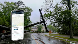
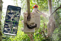
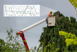
Map-first mobile platforms are the practical fix. When a field crew has real-time GIS data on their phone or tablet alongside their work orders — and can document conditions, log photos, and sync completed work on the spot — the gap between the back office and the field closes. Planners see what’s happening as it happens. Crews aren’t operating on last week’s information. And where cell service drops out, offline capability keeps things moving.
There’s a compounding effect here that’s easy to miss. Every inspection produces data that sharpens the next round of prioritization, and over time, that accuracy shapes where crews and budgets go next.

Nashville Electric Service: A Useful Case
Nashville Electric Service (NES) serves nearly 430,000 customers across 700 square miles of Middle Tennessee through roughly 5,900 miles of lines — a widespread operation where the speed of field coordination has real consequences. In early 2024, the utility rolled out a mobile workforce management platform to address a problem that was costing them badly in storm response.
After a storm hit, Engineering was working off ArcGIS data to track damaged circuits while Operations was fielding calls, texts and emails from the field and maintaining its own spreadsheet. The information rarely matched across teams. Sorting it out after a three-to-four-day storm event ran to about 150 staff hours in reconciliation alone — and that doesn’t count the crews showing up to circuits that had already been assessed, or the 25 to 40 hours of work assembling FEMA documentation after the event.
With the new platform in place, assessors track inspected areas in real time using circuit tracing and breadcrumb tools, and that picture flows live to the operations center. Assignments shift as conditions change. In the pockets of rural Tennessee where connectivity is unreliable, offline capability fills the gap.
NES has vegetation management on its roadmap for the same system. The specific workflows are different, but the underlying problem is identical — knowing where work has been done, what was found and where to send people next. That’s what the platform solves.
Labor and Budget Pressures Are Real
Vegetation management is already a hard job to staff. Line clearance arborists take years to develop, the workforce is aging, and the competition for qualified field technicians has gotten stiffer across construction and infrastructure sectors. A program that burns crew time on redundant checks, inefficient routing or data entry that should have been automated is burning something it can’t easily replace.
Optimized routing means more sites per day. Risk-prioritized queues prevent crews from spending time in the wrong places. Digital capture in the field means no one back at the office is rebuilding records from scratch.
None of these improvements is dramatic on its own. But together —especially in an environment where skilled arborist labor is scarce, they meaningfully increase how much risk a utility can reduce with the crews it already has. Fixed-cycle programs spread resources by calendar, which means high-risk and low-risk corridors get roughly the same attention on the same schedule, regardless of actual conditions.
Risk-based programs don’t ignore lower-risk areas — they just let the timing and intensity of intervention follow the evidence rather than the date.
A Note on Compliance Documentation
Ask a vegetation manager what happens when an audit notice arrives and the records live in three different systems. It’s a scramble. FAC-003-5 requires documented TVMPs, annual work plan execution records, inspection history and sustained outage reporting, and pulling those together from fragmented platforms is a multi-day project that surfaces gaps nobody knew were there until regulators started asking.
When that documentation emerges from one system as a natural byproduct of daily operations—timestamped, spatially grounded, and tied to work orders and field records — the audit stops being a crisis. NES’s experience illustrates the point: the same infrastructure that cut 150 hours of storm reconciliation work generates exactly the kind of field record trail that compliance reviews are looking for.
Regulators have made clear they’re pursuing TVMP design failures, not just trees touching lines. Getting the documentation right isn’t paperwork hygiene; it’s a genuine reduction in enforcement exposure.
Getting Started Without Overhauling Everything
Utilities that have made real progress on this tend to share a similar story. They didn’t start with a full transformation. They started with the data they had, determined where risk was concentrated and built better habits from there.
That usually means fixing the data before deploying the tools. Spatial analytics are only as useful as the GIS records that feed them, and there’s a pattern in utilities that skip this step — risk models don’t reflect what experienced arborists already know, and confidence in the system erodes. Get the data right first.
Integration and field adoption matter roughly equally after that. A platform connecting LiDAR, satellite data, inspection history, and weather inputs is more valuable than any single data source. And a tool that field crews don’t trust—because it’s clunky, unreliable offline, or wasn’t built around how they actually work—generates incomplete data, which undermines the model. Getting crews involved in selection early tends to change both outcomes.
The Underlying Case
Power outages cost American businesses and households an estimated $150 billion a year, per the Department of Energy, with vegetation the single largest cause. Grid load is growing faster than it has in decades. Communities in fire-prone areas are watching vegetation programs more closely than ever, and that scrutiny isn't going away.
Cycle-based vegetation management programs made sense in a more predictable world, one with steadier weather, narrower compliance requirements and easier labor markets. That world has changed. Utilities building data-driven, geospatially grounded vegetation programs now aren’t just managing today’s risk better. They’re building for whatever comes next.
About the Author
Mike Mitchell
Mike Mitchell is vice president of sales and customer success at Epoch Solutions Group, a provider of digitized, map-first field operations technology built around Esri’s ArcGIS platform and purpose-built for utilities. Epoch works with some of the largest electric and gas utilities in North America, supporting vegetation management, asset inspection, storm response and field workforce management across organizations that collectively serve more than 100 million customers. Mitchell partners with utility leadership and operations teams to modernize field programs and leverage spatial intelligence to improve reliability, compliance and operational efficiency.