Seeing the Unseen: Improving Storm Response in Electric Utilities
Key Highlights
- Extreme weather events are causing widespread damage to electrical infrastructure, leading to costly outages and service disruptions.
- Traditional assessment methods are limited by weather, darkness, and accessibility issues, delaying response efforts.
- SAR satellite technology offers all-weather, real-time imagery that improves damage detection during storms, wildfires, and floods.
- Persistent SAR monitoring helps utilities identify recurring vulnerabilities and plan long-term resilience strategies.
- Adopting advanced satellite tools is essential for utilities to respond swiftly, safely, and effectively in an increasingly extreme climate.
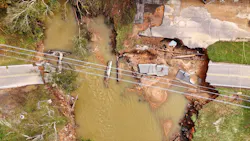
Extreme weather is intensifying risks to the electrical grid. Hurricanes and catastrophic flooding are crippling transmission and distribution networks across the Southeast as floodwaters and ground instability put critical assets at immediate risk. In the West, fast-moving wildfires are decimating electrical systems and leveling entire grid-connected communities. These escalating disasters are intensifying pressure on utilities, which must rapidly and safely restore power while operating with little real-time insight into the scope and severity of the destruction.
Electrical outages cost U.S. customers $44 billion annually, placing additional pressure on providers and local governments. Prolonged restoration efforts drive up operational expenses for utilities while frustrating customers, as response crews need to be deployed and equipment replaced.
Beyond the economic impact, outages disrupt hospitals, water treatment facilities, telecommunications networks, and emergency services. Restoring power is critical, but decision-makers often lack a complete picture. As storms increase in frequency and intensity, utilities must adopt more timely, all-weather monitoring tools to proactively predict and respond to disasters.
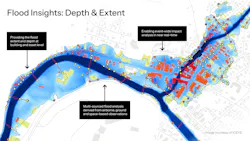
Satellite-based flood intelligence platforms deliver near real-time observational flood data to reveal infrastructure exposure as events unfold. Color-coded asset locations and customer building footprints reflect impact severity, enabling utilities to support restoration and damage assessment of critical assets during and immediately after a flood event, even through cloud cover and darkness.
The Visibility Gap
Traditional damage assessment methods often leave utilities slow to respond to natural disasters. The extreme weather that causes outages also prevents ground patrols and helicopter flyovers from safely assessing the situation while optical imagery is often obscured by clouds, smoke, or even limited hours of daylight. Meanwhile, roadways that remain flooded can delay crews while high winds and dense smoke ground aircraft.
This visibility slows decision-making. Without a comprehensive view of which areas are affected, response teams must operate on partial information or wait days before responding to outages. That uncertainty can lead to inefficient crew staging and resource allocation, prolonging the time without power. Re-energizing in affected areas without confirming conditions can create electrocution hazards or risk secondary fires in damaged buildings with active electric or gas connections. Every minute matters during an outage, and crews need reliable information to efficiently and safely respond.
The consequences extend beyond outage duration. Delays can affect reliability metrics, regulatory reporting, and public trust. In high-profile events, communities and policymakers expect rapid, data-driven restoration decisions. Meeting that expectation requires improved situational awareness across the full service territory.
Closing the Gap with All-Weather Monitoring
To address this challenge, utilities are exploring technologies that provide direct observation of on-the-ground hazard impacts, regardless of weather conditions. Synthetic Aperture Radar (SAR) satellites are a proven and reliable solution for delivering this capability.
Unlike optical satellites, which depend on sunlight and clear skies, SAR systems use radar to collect imagery during storms, at night and through wildfire smoke. This all-weather monitoring enables utilities to observe surface changes and infrastructure impacts when traditional methods are unavailable.
In practice, persistent SAR monitoring can support utility operations throughout an event in near real-time. Radar imagery detects floods and wildfire damage in hours instead of days and continues to update in near-real time so crews can make informed decisions about rerouting power and deploying resources to minimize service disruptions.
Persistent monitoring can also strengthen proactive storm readiness. Providers can use observational data from prior events to identify chronic vulnerabilities and build long-term system resilience. Analysis of more than 150 U.S. flood events since 2021 shows how historical SAR-based flood records can reveal patterns of repeated exposure, helping utilities identify assets, such as substations, that face recurring risk and need additional infrastructure.
At the same time, SAR data can transform wildfire recovery and preparedness. Wildfires, unlike floods, create dynamic smoke and rapidly shifting hazard zones, making damage evaluation and risk mitigation even more challenging. SAR satellites can “see” through smoke to generate building-level impact data where traditional satellites may only capture haze.
Adapting to a New Risk Landscape
Weather events are only becoming more extreme, placing additional strain on our nation’s power grid. Utilities must prioritize strengthening grid and energy resilience, and that starts with having the tools to measure and respond to these emerging threats.
For utility leaders, the question is no longer whether extreme events will occur, but rather how efficiently and safely they can respond when the inevitable happens. Closing the gap between impact and insight is one of the most practical steps utilities can take to control storm-related costs, strengthen operational performance, and build a grid prepared for the realities ahead.
In today’s risk landscape, the ability to see through the storm and beyond the smoke will define the next phase of transmission and distribution resilience.
About the Author
Mike Bennett
Mike Bennett is the Head of Government Solutions, North America for ICEYE. For over 15 years, Mike has worked in the weather and natural disaster industry, from operational forecasting and hazard communication in broadcast meteorology, to peril risk assessment and post-event forensics in the InsurTech space, to strategic account management and sales leadership around emergency management in SpaceTech.
In his current role, Mike has worked to help governments, utilities, and public sector organizations understand, ingest, and utilize ICEYE’s geospatial natural disaster insights to improve disaster response efforts, increase humanitarian aid operations, enhance hazard communication, strengthen community resilience, and fuel alternative risk transfer projects -- all focused around improving recovery outcomes for disaster survivors. This role includes overseeing efforts at the federal, state, and local level, across the utility sector, and work in public sector insurance globally, including in innovative parametric schemes for developing nations. While at ICEYE, Mike has also helped to lead the development of the monitoring, forecasting, and sa