From Ground Patrols to Geospatial Intelligence: Reinventing Distribution Vegetation Management
Key Highlights
- Liberty Utilities transitioned from slow, ground-based inspections to aerial lidar surveys, significantly increasing inspection coverage and precision.
- Lidar technology reduced inspection costs from nearly $2,000 to under $800 per mile, especially beneficial in rugged, high-cost terrains like California's Sierra Nevada.
- The program allows for rapid identification of encroachments and hazard trees, enabling quicker risk mitigation and improved wildfire prevention efforts.
- Integration of satellite tree health data helps prioritize stressed or dying trees, further reducing wildfire risk and enhancing vegetation management strategies.
- Using high-accuracy lidar data, Liberty can demonstrate compliance and transparency to regulators and customers, fostering trust and accountability.
In the Sierra Nevada, where steep slopes, dense conifer forests and high fire‑threat conditions define daily operations, vegetation management is essential. Liberty Utilities (CalPeco Electric) LLC, an electric utility that serves customers in North and South Lake Tahoe, maintains more than 700 miles of overhead primary lines in terrain that challenges even the most seasoned field crews.
Historically, the vegetation management program relied on traditional, ground‑based inspections. Arborists walked every span, sometimes hiking miles over mountains, to measure clearances and identify tree hazards. The work was slow, expensive and increasingly mismatched with the pace and scale of wildfire risk.
In the last few years, Liberty made a strategic shift: applying aerial lidar surveys and geospatial analytics to the distribution system. While many utilities at that time questioned whether lidar was the right tool for distribution networks Liberty’s experience shows that not only does it work, it has fundamentally transformed Liberty’s ability to manage vegetation risk, improve safety and meet regulatory expectations with confidence.
Rethinking an Unsustainable Model
Liberty’s entire service territory lies within California’s high fire-threat districts. The geography is rugged, access is limited and the cost of field labor is among the highest in the country. Before lidar, Liberty’s inspection cycle was intended to be three years. However, in practice, Liberty doubled the inspections to address the wildfire environment in which Liberty operates.
Liberty faced a choice: dramatically expand arborist workforce or find a more efficient way to work.
Lidar offered the efficiency that was sought. Aerial surveys eliminated access barriers, allowing Liberty to “fly the lines” instead of sending crews deep into the mountains. Lidar also provided measurements that are more precise than handheld rangefinders, capturing tree height, wire position and vegetation proximity with centimeter‑level accuracy.
Initially, Liberty partnered with NV5, a geospatial software and services provider, to pilot use of lidar to measure clearance between wires and vegetation. The results were immediate. Lidar identified encroachments Liberty would not have caught for years under a traditional cycle. This early success gave Liberty the confidence to expand the program.
Building a Distribution‑Focused Lidar Program
Now NV5 flies Liberty’s entire system at the end of the growing season each year, typically in the late summer or early fall. This timing helps Liberty capture the full season’s growth, analyze data, and generate work orders and dispatch crews within a few months.
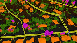
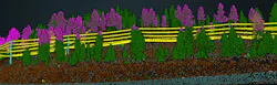
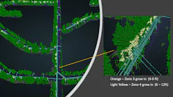
The lidar is collected at high density (≥30-35 points per square meter) for full wire capture, even in Tahoe’s dense conifer forests. NV5 processes the data to model Liberty’s network, segment vegetation, and run analyses of tree grow‑in, fall‑in and overhang. Liberty also receives tree‑level attributes, including height, crown geometry and the direction trees are leaning.
This information flows into Liberty’s internal geographic information system (GIS) and work management systems. Instead of walking every mile, arborists can pinpoint locations where lidar shows a clearance or fall‑in concern and inspect those locations. As the program matured, Liberty added satellite‑based tree health monitoring to flag stressed vegetation. While still evolving, this integration helps Liberty identify dead or dying trees earlier and refine prioritization even further.
Operational Impact: Faster Cycles, Lower Costs, Better Targeting
The shift from ground patrols to lidar-driven geospatial intelligence has reshaped Liberty’s operations in several measurable ways.
More inspection miles – By adding lidar, Liberty has been able to increase the annual inspection scope from 383 miles in 2019 (just prior to implementing the technology) to more than 1,000 miles a year currently. Lidar affords Liberty greater efficiency compared to ground-based inspections, enabling Liberty to address risk more quickly by dispatching tree crews directly to locations that need attention. It also re-directs arborists to focus on hazard tree assessments, unit reduction and customer service.
Lower costs in a high‑cost market – California arborists are expensive, costing three to four times more than those in other states. Lidar inspections reduce the cost per mile, particularly over challenging terrain where human access is difficult. A recent analysis shows that it costs $1,983 per mile for ground-based inspections versus $773 per mile for lidar. Additionally, with lidar data, Liberty can reach out to customers via mail to inform them when tree pruning is required, rather than sending arborists to each site before crews are dispatched.
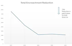
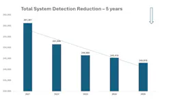
Faster cycle times for identifying and mitigating risk – In the early years of Liberty’s wildfire mitigation ramp‑up, the workload nearly tripled as areas of risk were more clearly identified by lidar. But the workload stabilized as Liberty caught up and began maintaining the intended inspection cycles. Lidar also has helped Liberty quickly identify where new construction needs to be modified for compliance, something that may have not been discovered for years with boots on the ground.
Improved prioritization in high‑risk wildfire districts – With lidar, Liberty can quantify risk, not just identify it. NV5’s analytics have enabled Liberty to model conductor sag and position; score trees based on height, distance and fall‑in potential; analyze tree lean direction; integrate fire‑risk polygons and responsibility areas; and combine satellite‑derived tree health with lidar‑based structure. This combined data enables Liberty to prioritize work where it matters most to reduce fire risk.
Fostering Trust with Greater Transparency
In California, defensibility matters. Regulators expect utilities to demonstrate that they are meeting requirements with auditable data.
Lidar has become a powerful tool for transparency. With 3 cm to 9 cm accuracy, Lidar can show exactly how close a tree is to a conductor, how tall it is and whether it poses a fall‑in risk. When customers question pruning decisions, arborists can reference lidar data to show them why the work is necessary.
Executives supported the program early, recognizing that while the first years would be front‑loaded with work, the long‑term benefits would be substantial.
Liberty is now exploring how lidar can support broader wildfire mitigation initiatives. For example, Liberty is working with the U.S. Forest Service on fuel‑reduction projects along 300‑foot corridors. Lidar identifies dense stands, stressed trees and areas where treatment will have the greatest impact.
Start Simple and Pick the Right Partner
Utility colleagues often tell me they wish they could hand lidar data directly to tree crews. My response is simple: You can. Liberty’s experience shows that is possible when you start with a clear objective and do not overcomplicate the first year. For Liberty, it was: “Tell us how far trees are from wires.” Once that lidar data foundation was in place, Liberty was able to layer on additional analytics.
Another piece of advice: Don’t underestimate the value of a trusted partner. Lidar is not a commodity. The right partner will yield the quality of the data, the repeatability year-over-year and the ability to translate analytics into actionable work packages. This was the key to making Liberty’s program a success.
A New Model for Distribution Vegetation Management
Lidar has allowed Liberty to replace its reactive, labor‑intensive inspections timeline with a proactive, intelligence‑driven vegetation management program. In a region where wildfire risk is high and terrain is unforgiving, this shift has improved safety, reduced costs, and strengthened operational and regulatory posture.
For utilities navigating similar challenges, Liberty’s experience shows that lidar is not just viable for distribution, it may be the most effective tool available.
About the Author
Peter Stoltman
Peter Stoltman is the senior manager of Wildfire Prevention for Liberty Utilities (CalPeco Electric) LLC, a California electric utility serving the Lake Tahoe Basin and surrounding communities. Prior to his current role, Stoltman was the manager of Vegetation Management at Liberty, where he helped modernize the utility’s approach to wildfire risk reduction. He has extensive experience as a consulting arborist across residential, commercial, municipal, and utility sectors, holding various positions in both public and private organizations. Stoltman earned his Bachelor of Science degree from the University of Idaho College of Natural Resources and is an International Society of Arboriculture (ISA) Board Certified Master Arborist.