Advanced Wildfire Research Could Save Billions, Protect Vital Power Supply
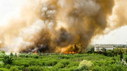
Wildfire modeling has advanced enough in the past 10 years that University of British Columbia (UBC) researchers say devastating losses like those witnessed in Fort McMurray, Alta., could become easier to prevent.
Dr. John Braun and Dr. Kevin Hanna are among the first to join the newly created US-Canada Centre on Climate-Resilient Western Interconnected Grid. Their work is helping highlight the need for improved wildfire prediction models and eventually establish better data access to mitigate or prevent damage to vital North American infrastructure.
“Today’s technology allows us to gather much more high-quality data than even a decade ago,” says Dr. Braun, a Professor of Mathematics and Statistics in UBC Okanagan’s Irving K. Barber Faculty of Science.
Heightened consideration of topography and advanced data collection tools such as satellites and drones can significantly enhance fire models and help determine fire spread rates, especially in alpine areas, he says. Correctly accounting for this can substantially augment fire models’ accuracy, allowing for more effective and timely firefighting strategies and infrastructural safety assessments.
Dr. Braun’s research, focusing on fire spread models, explores stochastic models that consider uncertainty. These can offer a more reliable range of predictions than deterministic models, which offer one likely conclusion. He cites the 2016 Fort McMurray fire, where advanced stochastic models could have significantly improved decision-making and resource allocation, potentially averting extensive damage and loss.
The Fort McMurray fire is still Canada’s most costly disaster and left behind $9.9 billion worth of damage. It destroyed 2,400 homes and forced 88,000 people to evacuate. During the emergency, a turning point for firefighters came as the blaze jumped a river and looked like it could pose an immediate threat to the city itself.
Officials used a deterministic model and estimated flames could reach city limits by 11 pm. That led them to divert resources to where they were needed most at the time. Dr. Braun says they may have reconsidered this decision if they’d had access to today’s tools.
“Initial calculations showed a five per cent probability that the fire could reach the city limits by 6 or 7 pm—which is actually about when it did,” Dr. Braun says. “If they had known this, they might have made a different decision. These models serve as essential decision support tools, improving both infrastructure safety and firefighting efforts.”
The researchers are also aiming to further risk and vulnerability assessments used in planning projects. Dr. Hanna is examining the specific information that regulators need for approving power projects in Canada. Their research seeks to establish robust processes for assessing risk and safety points along electric transmission routes, ensuring they withstand the impact of sudden events like wildfires.
“This project provides a unique platform to unify various research disciplines for addressing energy resiliency and security in the face of evolving climate challenges,” says Dr. Hanna, an Associate Professor in Earth Sciences and Director of UBC’s Centre for Environmental Assessment Research.
The centre has received US$5 million from the US National Science Foundation and C$3.75 million from the Natural Sciences and Engineering Research Council of Canada. It involves 11 North American universities and institutes that aim to address the growing challenges of wildfires, heatwaves, drought and flooding.
Such extreme weather events not only endanger lives and the environment but also threaten the grid providing power to millions of people across two Canadian provinces and 14 western states. The western interconnected grid stretches from the northern edge of British Columbia to the Mexico border, and from the California coast to the Rockies. It serves roughly 80 million people over 4.66 million square kilometres.
“This will help safeguard infrastructure, particularly power lines and natural gas systems, and potentially save billions in damage and replacement costs,” Dr. Hanna says.
About the Author
T&D World Staff
Content Team
Nikki Chandler
Group Editorial Director, Energy
[email protected]
Jeff Postelwait
Managing Editor
[email protected]
Christina Marsh
Senior Editor
[email protected]
Ryan Baker
Associate Editor
[email protected]
Amy Fischbach
Electric Utility Operations
[email protected]
Rich Maxwell
Community Editor
[email protected]
Gene Wolf
Technical Editor
[email protected]
