SDG&E Expands Drone Program to Detect Damage
Following the devastating 2007 wildfires, San Diego Gas & Electric Co. launched its wildfire mitigation program, making significant investments in a wide range of technologies designed to help significantly reduce the chances of a utility-related wildfire. One such technology is the use of unmanned aerial systems, or drones.
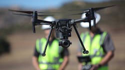
Drones have proven highly valuable, enabling the utility to complete a wide variety of missions aimed at not only reducing the risk of wildfires but also increasing the safety of its employees while reducing costs. One of these missions, and perhaps the most critical, is the quick and efficient assessment of power lines and equipment within areas at risk of wildfire.
Preventive Assessments
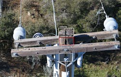
Every year, San Diego Gas & Electric (SDG&E) uses drones to conduct thousands of routine preventive assessments on its infrastructure to identify and repair damage before an outage, but these assessments become particularly critical following extreme weather conditions, in which the utility may have had to proactively turn off power as a last resort to help protect homes and communities from utility-related wildfire risk. Infrastructure must be carefully inspected for damages prior to reenergizing the lines and restoring power as quickly and safely as possible.

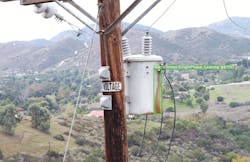
Since then, the company’s use of drones has expanded and the utility developed its Drone Investigation, Assessment & Repair (DIAR) program. The DIAR program includes the deployment of numerous highly advanced drones to assess tens of thousands of poles, power lines and equipment and capture millions of images, which are then uploaded to a central database for review by qualified linemen. The advantages of drone inspections over ground inspections were quickly realized, including the top-down and close-up views drones provided. This helped the utility to identify additional issues to repair, leading to a more effective inspection program. However, SDG&E also realized drones could be used for more applications.
“I knew they were collecting the images, so the question was, ‘Could we apply computer-vision models to help us be more efficient long term in our maintenance and fire prevention efforts?’” said Gabe Mika, strategic technology and investment manager for SDG&E. “Could we use the drone shots to build machine-learning models, and make this kind of drone program not just real, but something that had real benefits for our customers?”
Intelligent Image Processing
Analyzing millions of images is an arduous task and takes time. By using artificial intelligence, the digital acceleration team in the Information Technology department was brought in to see if the process could be streamlined further. Through intelligent image processing, SDG&E is now using artificial intelligence and machine learning to automatically detect damaged assets that could lead to an ignition.
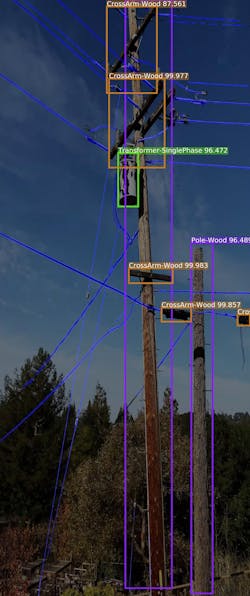
“First, machine learning models were created to detect unique asset and damage conditions from the drone program imagery, including insulator, transformer, wooden pole and crossarm damage,” Mika explained. “We involved qualified electrical workers to train the machine models to identify specific equipment damage by drawing a bounding box around an example of damaged equipment on an image. Then, that image is used to teach the machine software to automatically identify the same pattern of damaged equipment in future images.”
AI & Machine Learning Models
Since officially kicking off in April 2020, the project team has built more than 35 artificial intelligence and machine learning models. Each one of these models is designed to automatically identify an SDG&E asset and identify a specific type of damage or specific type of condition.
The DIAR program is just one of many wildfire mitigation projects included in SDG&E’s wildfire mitigation plan filed annually with the California Public Utilities Commission. The plan outlines ongoing practices and additional improvements SDG&E will make to mitigate wildfire threats.
Editor’s note: For more information on SDG&E’s 2022 plan, visit sdge.com/2022-wildfire-mitigation-plan.
Tom Fries has been with SDG&E Aviation Services for over 5 years. Prior to coming to SDG&E, Tom worked for General Atomics Aeronautical with program and engineering teams. Tom is a retired Marine with 22 years of active duty as an F/A-18 pilot. Tom has his undergraduate degree in Mechanical Engineering Technology from Temple University, master’s degrees from both Georgetown University and University of San Diego, and Aviation Safety and Security certificate from University of Southern California.
Key Facts
Drone program start: 2014
Drone Investigation, Assessment & Repair program start: 2020
Number of drones: 26
Key use cases:
- Infrastructure assessments
- Vegetation assessments
- Post-wildfire assessments
- Line pulling
l Construction monitoring
l Accessing remote areas
l Pinpointing outages
About the Author
Tom Fries
Tom Fries has been with SDG&E Aviation Services for over 5 years. Prior to coming to SDG&E, Tom worked for General Atomics Aeronautical with program and engineering teams. Tom is a retired Marine with 22 years of active duty as an F/A-18 pilot. Tom has his undergraduate degree in Mechanical Engineering Technology from Temple University, Masters Degrees from both Georgetown University and University of San Diego, and Aviation Safety and Security certificate from University of Southern California.