It used to be that utility reliability managers like Denton McGregor of Black Hills Energy could plan their wildfire responses during a roughly four-month fire season, from late summer through fall, when the landscape was more susceptible to fires. Now, for most utilities across the country, high-alert wildfire season has stretched into year-round fire risk awareness and mitigation activities.
McGregor said some of the biggest fires in the utility’s service areas have recently been during the middle of winter. “It brought to light that we need to be ready to take fire mitigation and action any time of the year, which wasn’t as concerning
30 years ago,” he said.
In addition to the threats to public safety, homes and other property, the impact on infrastructure from wildfires are a well-known and well-documented risk for utilities. Whether ignited by natural causes, human factors or utility infrastructure, such as power lines or aerial communications facilities — as was the case with the 2018 Camp Fire in California — wildfires often cause utilities to preventively pause power delivery to millions of customers and deploy crews and resources into the danger zone on short notice to address the additional risks. Utilities also must plan for restoration work following a wildfire event.
A recent series of studies shared by the World Economic Forum point to multiple reasons for the increase in frequency and intensity of wildfires. Still, the main conclusion that has immediate impact on utilities is the consensus among researchers that the length of the fire season has increased by more than 80 days — expanding the high-alert time frame from four months to more than six months of the year. The longer fire season increases the need for more predictive and proactive planning by utilities and municipalities across the country.
DTN, a data, analytics and technology company that helps utilities to mitigate, plan and prepare for all types of weather impact, reports increased demand from utilities and municipalities for weather insights during fire seasons. Utilities need more advanced ways to assess weather threats during an extended fire season, beyond the traditional weather forecast. Fire-weather forecasting layered with utility-specific risk planning can help surface potential impact scenarios.
Fire-Weather Forecasting
Many utilities rely on fire-weather forecasting, which uses atmospheric conditions to evaluate wildfire risk within a 3- to 5-day outlook. Predicting and forecasting fire weather involves constantly monitoring wind, temperature and humidity, all of which are major factors that fuel wildfires.
Fire-weather experts also can work with geospatial software that monitors the weather conditions of known fires to help predict where the spread is going to occur, another important factor for fighting wildfires. This kind of data, when interpreted along with utility assets layered within a geographic information system, can help utilities to anticipate and track the impact of potential wildfire risk to electric infrastructure.
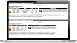
Fire-weather forecasting is beneficial for an individual grid or a utility in a high-risk area but may not solve the problem for utilities proactively monitoring risk and response over their entire service area. A risk-planning index is a next-step advancement for utility wildfire risk mitigation. The index uses weather inputs most important to the utility, such as wind speed, wind gusts, lightning, heavy rains, snow and ice accretion. The thresholds are categorized by risk, from low to high, for a set amount of forecast time and customized to a utility’s service area and triggers. It helps to bring the entire response operation into one comprehensive and reliable plan.
Why Have Risk Thresholds?
Most utilities have assets and infrastructure spanning diverse geographies and topography exposing them to potentially different weather risks at the same point in time. This is the challenge Black Hills Energy encounters when assessing daily wildfire risk during an expanded fire season. The utility has service regions in Colorado, Wyoming and South Dakota that include grasslands, forest and mountainous terrain. At any given time, one area may be more susceptible to drought and high winds, while another area is more mountainous and has a higher threat from dense vegetation.
Typically, a red-flag warning — issued when the combination of dry fuels and weather conditions support extreme fire danger — affects all or most of Black Hills Energy’s service territories. However, this does not account for a risk profile where one area may require a more immediate or different response than others within the red-flag warning area. According to McGregor, in these situations, the utility’s incident control center used to rely on system operators to become “ad-hoc meteorologists” on a localized level to assess risk and weather threat for the specific territory. The control center then had to juggle multiple inputs to create and deploy response plans.
What the utility needed was a notification system that could send one source of truth for weather and critical burn information that correlated with the risk in each of the areas within the service territories. “That was the tool that we were really missing,” McGregor said. “There are online websites to find out if there is a red-flag warning for an area, but when you are talking about a system operator gathering fire-weather information and alerts, and across service territories that are thousands of miles apart, it is difficult to aggregate the information and develop a proactive response.”
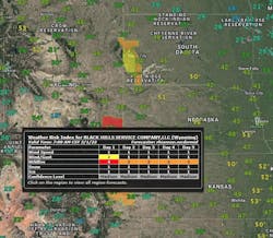
Black Hills Energy chose to work with DTN to tailor its Energy Event Index (EEI) to help assemble and digitally deliver five-day-ahead wildfire risk profiles for the utility’s service area and improve risk communication among system operators.
Defining And Measuring Risk
Black Hills Energy classified predetermined regions based on terrain type and fire-weather zones to create a burn index. DTN aligned delivery of real-time fire-weather data and fire-weather forecasts, as well as the meteorological data modeling that paired with the Black Hills Energy risk thresholds and service area, to create a comprehensive risk forecast of the service areas during fire season.
“A valuable component of the Energy Event Index is that the risk can scale up or down based on the combination of meteorological and fire-weather data, meaning that we are always receiving the most update information in a dynamic decision-making process,” McGregor said.
Having a comprehensive risk-planning index improves internal communication of weather risk, operational and response decisions and emergency preparedness. The weather data and models used in EEI offer geocentric forecasts during an event like a wildfire and are interpreted by a team of DTN meteorologists. This helps clarify the information and allows the company to share forecast confidence and potential areas of focus in a clear, precise way that gives the command center consistent information to improve their decision-making during a time of crisis.
According to McGregor, with a single source of reliable information and established risk triggers, it has been easier to declare an incident command event and initiate emergency protocols to engage and optimize resources.
An Enhanced Approach
McGregor said that working with a risk-planning index has had additional benefits for the utility. His crews now know what circuits and projects could be impacted during building and reconstruction, and they can make decisions based on wildfire risk forecasts as to whether they will perform work on a given day.
Black Hills Energy also added an additional layer of observation for each circuit. It monitors the highest-risk circuits and lines using the threshold triggers from its burn index. The T&D control center then reviews and initiates fire risk mitigation activities for high-risk circuits based on the risk forecast.
The additional risk indices also benefit the employees and community who live and work in the service areas. Scheduling restoration work based on wildfire risk helps to reduce potential hazards and efficiently continue work without unforeseen delays.
The utility has added additional data points to the risk-planning index to further improve wildfire mitigation. In addition to the EEI, Black Hills Energy is evaluating additional variables, such as circuit risk, vegetation in the area, response time for fire trucks, population and topography.
“Historically, a utility was blind to the actual wildfire risk on any given day. Now, we are taking our insights and decision-making a bit further,” McGregor said. “It has really helped mature our overall wildfire posturing across the entire utility.”
Wildfires are considerably disruptive to utility operations, and it appears the fire season will continue to expand. Whether it is preparing for, responding to or restoring service following a fire event, having a risk-planning index established in advance and consistently delivering right-time data to response crews is proving to be one of the better ways for utilities to manage the increasing risk.
Renny Vandewege ([email protected]) is vice president of Weather Operations at DTN, where he is responsible for developing strategic direction for weather business serving the aviation, energy, offshore, shipping, transportation, and sports & safety markets, as well as providing leadership to 200+ operational meteorologists across weather forecast rooms globally. Prior to joining the private weather industry, Vandewege served as the director of the Broadcast Meteorology Program at Mississippi State University, advising and training over 200 broadcast meteorologists in his time teaching in the program. He began his career in meteorology as a broadcast meteorologist at WTOK in Meridian, MS and KCTV in Kansas City, Missouri, most notably covering historic Hurricane Katrina as it made landfall in Mississippi. Vandewege holds a master’s degree from Mississippi State University.
About the Author
Renny Vandewege
Renny Vandewege ([email protected]) is Vice President of Weather Operations at DTN, where he is responsible for developing strategic direction for weather business serving the aviation, energy, offshore, shipping, transportation, and sports & safety markets, as well as providing leadership to 200+ operational meteorologists across weather forecast rooms globally. Prior to joining the private weather industry, Renny served as the director of the Broadcast Meteorology Program at Mississippi State University, advising and training over 200 broadcast meteorologists in his time teaching in the program. He began his career in meteorology as a broadcast meteorologist at WTOK in Meridian, MS and KCTV in Kansas City, MO, most notably covering historic Hurricane Katrina as it made landfall in Mississippi. Renny holds a master’s degree from Mississippi State University.


