From Assumption to Proof: Verifying Vegetation Management with Measurable Aerial Intelligence

Utilities invest millions annually in vegetation management to protect grid reliability, reduce wildfire risk and maintain regulatory compliance. Yet verification often relies on selective ground patrols and helicopter flyovers that are difficult to scale or defend. A recent 77.7-mile corridor mission demonstrates how LiDAR-based aerial intelligence can shift vegetation oversight from assumption to measurable, auditable proof.
The Verification Gap in Vegetation Management
Vegetation management can be one of the most operationally challenging and publicly visible line-of-business activities within electric transmission and distribution. Utilities spend considerable capital and O&M budget dollars on vegetation clearance, trimming and treatment programs to maintain clear corridors, help prevent outages and mitigate wildfire risks.
The work itself is carefully defined, contracted and executed with established scopes and standards. Verification, on the other hand, can be less precise. For most programs, validation is achieved through selective ground inspections, limited span checks or helicopter flyovers to eyeball corridor conditions. All these measures offer valuable oversight but are episodic in nature and based on sampling. They rarely result in an accurate, corridor-wide record of measurable clearance conditions, and what happens between those spans is largely assumed.
The result is a verification model built largely on professional judgment and spot validation rather than comprehensive measurement. Work is completed. Invoices are submitted. Field teams validate portions of the corridor. But along thousands of miles of rights-of-way (ROW), utilities frequently don’t have a completely documented, repeatable, digital record of clearance that can be referenced months or even years down the road.
Under increasing regulatory scrutiny and with wildfire exposure rising in many states, utilities are being asked to prove not just that vegetation work was completed, but that it was done to defined standards throughout the entire corridor. Verification must evolve from assumption to defensible proof.

Why Traditional Verification Breaks at Corridor Scale
Helicopter patrols and ground-based inspections have long supported vegetation oversight. Crewed aircraft can quickly traverse large segments of infrastructure, and experienced observers can identify obvious encroachments or missed spans. Ground patrols provide closer inspection where necessary.
At corridor scale, however, these approaches become increasingly constrained. Conducting regular helicopter flyovers of an entire corridor footprint introduces added risk and adds significant coordination, complex mobilization, and substantial costs. Plus, visual verification is still just that, visual. Clearance estimation depends on observer interpretation rather than direct measurement.
Ground patrols provide high-detail verification in targeted areas, but they are impractical as a comprehensive confirmation method across entire service territories. Dispatching crews solely to verify completed vegetation work strains field resources and extends verification timelines. Inspectors can physically access only a fraction of spans within a reasonable timeframe, and the documentation they produce is typically narrative or photographic rather than measurement-based.
There is also a matter of timing. Verification that occurs weeks after contractor crews have left the corridor captures conditions as they exist at that moment, not necessarily as they existed at project close. Seasonal growth, weather events and other factors can alter the picture. Without a timestamped, measurement-based record taken at completion, the evidentiary value of delayed confirmation is limited.
The challenge is not performing vegetation management. The challenge is proving, at scale, that prescribed clearance standards have been met throughout the system.
From Visual Confirmation to Measured Clearance Modeling
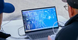
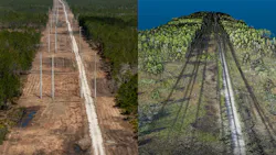
Advancements in drone-based LiDAR and high-resolution imagery allow for an entirely different approach to vegetation verification. Instead of relying on visual confirmation, LiDAR workflows enable utilities to build a measurable 3D model of the entire transmission corridor.
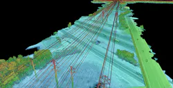
The LiDAR sensors produce data points that record the position of the conductor, terrain, and surrounding vegetation with an accurate spatial reference. When processed and modeled, these datasets allow utilities to measure vegetation-to-conductor clearances directly within a digital environment. RGB imagery provides contextual reference, while LiDAR-derived modeling enables objective clearance calculation. The result is not simply an image of a span, but a measurable representation of its condition at a defined point in time. This distinction holds considerable weight when companies must demonstrate compliance with regulators or respond to post-outage inquiries.
In a verification workflow, a digital baseline can be captured before vegetation work begins, followed by a re-flight after contractor completion. Clearance modeling can then confirm whether vegetation has been removed to required distances and whether any residual encroachments remain.
Most importantly, this process creates an archivable dataset. Rather than unreliable assurance or limited random sampling, utilities can have corridor-wide digital records they can refer to for audits, regulatory responses or future planning.
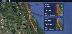
DAB to Mims Corridor-Scale Demonstration: 77.7 Miles of Transmission Infrastructure
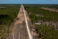
Censys Technologies recently conducted an aerial mission to illustrate how this verification approach performs on an operational scale. Conducted across 77.7 miles of transmission corridor, the mission combined LiDAR and RGB data acquisition to model vegetation conditions along the full route.
The operation required coordination across multiple airspace environments and terrain conditions. Over the course of the mission, 140 GB of raw data were collected, including 95 GB of high-resolution imagery and 45 GB of LiDAR point cloud data. Following the collection, raw data were prepared for platform ingestion in approximately 4.5 hours. Once ingested, automated LiDAR processing and clearance modeling were completed in 39 minutes.
The key takeaway is the pipeline, from aircraft to measurable output, demonstrated that corridor-scale vegetation modeling can be accomplished within the same operational day.
Within a three-dimensional evidence viewer, Censys engineers examined conductor geometry, surrounding vegetation, and clearance distances across the entire 77.7-mile corridor. Rather than reviewing selected spans, the engineers had access to a modeled representation of the full route.
The scale of this mission carries significance. Modeling vegetation conditions across nearly 80 miles in a single mission confirms that LiDAR-based verification is not confined to pilot programs or isolated spans. It can be executed at corridor scale with defined processing timelines and structured outputs.
Verification Without Helicopter Dependency
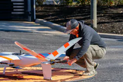
Historically, utilities have long performed helicopter flyovers and targeted ground patrols to verify vegetation clearance along transmission corridors. Though useful in specific cases, those approaches are costly, infrequent and challenging to scale across thousands of miles. Corridor-scale LiDAR acquisition, on the other hand, allows utilities to model measurable clearance without flying crewed aircraft.
During the 77.7-mile DAB-to-Mims mission, LiDAR and RGB data were acquired, processed, modeled and validated to show vegetation conditions. Utilities can survey and verify clearance along miles of corridor, eliminating the need for helicopter spot inspections. The distinction is not simply aircraft type. It’s the methodology. Helicopter patrols primarily provide visual assessment. LiDAR-based workflows generate quantifiable clearance measurements within a digital model. The difference shifts verification from observational confirmation to measurable validation.
Reducing dependence on crewed aircraft for corridor-wide verification also allows utilities to explore more frequent and repeatable confirmation cycles while maintaining a defensible record of vegetation conditions. When each acquisition cycle produces a timestamped, measurable dataset, the cumulative archive grows into a longitudinal record of corridor health across seasons and years.
The Data Pipeline: From Aircraft to Audit Record
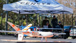
Effective vegetation verification depends not only on data capture but on structured processing and documentation. In the 77.7-mile mission, the workflow followed a defined sequence: flight planning and airspace coordination; LiDAR and RGB data acquisition; raw data preparation in about 4.5 hours; platform ingestion; automated processing and clearance modeling completed in 39 minutes; and three-dimensional visualization and evidence review.
Capturing and processing data within a single day is operationally significant because it accelerates decision-making and shortens the time between collection and action. When processing pipelines lag data collection, insight is delayed and verification cycles extend. In this case, modeled clearance outputs were available shortly after ingestion, enabling same-day analysis. For utilities that previously waited weeks to months for processed inspection results to arrive from third-party vendors, that compression of the timeline changes how quickly field decisions can be made and documented.
It is equally important to note that this creates a permanent record. LiDAR point cloud, the imagery associated with it, and modeled clearances can all be archived and referenced later during follow up audits/investigations. Verification of vegetation changes from saying the corridor was checked to having a timestamped record to measure against it.
Strengthening Contractor Oversight and Compliance Confidence
Objective measurement supports more transparent contractor oversight. When vegetation removal is evaluated through a digital clearance model rather than selective span review, verification becomes consistent across the entire corridor.
This approach does not imply contractor noncompliance. Instead, it provides a standardized confirmation method that treats all completed work consistently. Utilities can demonstrate that work was evaluated against defined clearance thresholds and that the evaluation covered the full route rather than representative samples. Considering regulatory agencies are demanding more defensible documentation, verification which can be measured improves program credibility. It also allows for more constructive discussions with contractors because everyone is referencing the same objective data set versus differing recollections of field conditions.
Increasing Inspection Cadence Without Increasing Field Burden
Inspection frequency has historically been constrained by costs and the logistics of scheduling helicopters and ground dispatch. When confirmation requires crewed aircraft mobilization or extended field patrols, increasing inspection cadence becomes difficult to justify.
A LiDAR-based verification model enables a different scalability. If corridor-scale data acquisition can be accomplished in hours and analysis in less than an hour, utilities are not locked into annual or multi-year timeframes for reinspection. Instead, they can consider more frequent validation, especially in higher-risk areas, without increasing the burden on field crews or budget. Digital verification enables a more dynamic vegetation management program because it eliminates the largest operational constraint: getting boots (or eyes) on the corridor. If airborne acquisition can be scheduled/tracked/flown in a single operation, and processed data is delivered on the same day, the frequency of inspections becomes a budget and scheduling question rather than a field capacity constraint.
From Inspection to Continuous Vegetation Intelligence
Perhaps the most significant shift enabled by measurable aerial modeling is the transition from episodic inspection to continuous vegetation intelligence. Where there is an existing baseline LiDAR model of a corridor, reflights can be compared to previous models. Utilities can see trends in vegetation growth rates, pinpoint new encroachments and determine which areas should be treated before clearances are affected. Species with aggressive growth rates can be flagged earlier. High-risk zones can receive more frequent attention without requiring proportional increases in field staff. This transforms vegetation management from reactive correction to proactive planning. Rather than waiting for encroachments to happen or cause outages, utilities can depend on modeled clearance trends to plan work cycles. In wildfire-prone regions and densely populated service territories, that proactive capability enhances both reliability and public safety.
The 77.7-mile corridor mission illustrates that this approach is operationally feasible on a meaningful scale. With defined capture volumes, documented processing timelines and structured three-dimensional evidence outputs, corridor-wide verification can be executed efficiently and archived for long-term reference. The mission was not a controlled demonstration. It was an operational deployment, and its outputs were immediately available for engineering review and compliance documentation.
Proof as the New Standard
Vegetation management will always be a utility responsibility. However, expectations around verification are changing, and the gap between what utilities have historically verified and what regulators, insurers and others expect is growing. Stakeholders want objective proof that activities occurred as required, not just the ability to check a box. Regulators need defensible documentation. The public expects transparency.
LiDAR-based corridor modeling does not replace vegetation crews or contractor expertise. It strengthens the oversight framework that surrounds them. By producing a measurable, archived record of vegetation-to-conductor clearances across 77.7 miles of transmission infrastructure and processing that data within hours of capture, this mission and workflow demonstrates that proof can be both scalable and repeatable.
As utilities navigate rising risk exposure and operational complexity, assumption-based verification is no longer sufficient. Corridor-scale, measurable aerial intelligence offers a path forward: one where vegetation management is supported by objective data, structured workflows and documentation that can withstand scrutiny from any direction. Utilities that establish this kind of evidentiary foundation are better positioned to respond to regulatory inquiries, support insurance reviews and demonstrate program integrity to the communities they serve. In that model, verification becomes not a sampling exercise but a comprehensive, auditable standard.
About the Author
Michelle Anastasio-Festi
Michelle Anastasio-Festi is a digital marketing and content development specialist at Censys Technologies in Boca Raton, Florida. She is focused on thought leadership, demand generation and technical storytelling across transportation, utilities and critical infrastructure markets. Her work centers on simplifying complex technologies, including autonomous systems, AI-driven analytics and persistent monitoring, for operational and infrastructure leaders.