Leveraging High-Density Distribution LiDAR in Detroit
Two years ago, DTE Energy faced a limited operations and maintenance budget for vegetation management along with territory-specific challenges. The Detroit, Michigan-based utility set a goal to decrease vegetation-related outages while optimizing its vegetation management budget.
To better understand the risk across its system, DTE considered implementing a light and detection ranging (LiDAR) survey, commonly used by utilities to provide accurate measurements of vegetation proximity to conductors of highly regulated transmission lines administered by the North American Electric Reliability Corp. (NERC). A LiDAR survey also could play an integral role in helping the utility to transition from cycle-based maintenance to condition-based maintenance.
In addition, DTE was interested in whether LiDAR analytics could provide similar accuracy and value to its distribution lines. Would the return on investment (ROI) lower the utility’s overall vegetation management spend?
Pressing Problems
To test whether LiDAR could provide the desired ROI, the utility looked inward at its service territory. DTE’s territory contains roughly 31,000 miles (49,890 km) of distribution lines and sub-transmission lines. Partially a result of Detroit’s economic downturn, DTE experienced population loss and urban blight, leaving the utility with fewer customers and putting stress on its vegetation management budget.
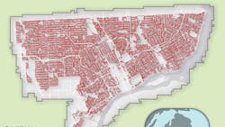
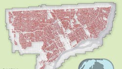
The downturn also left Detroit with rising safety concerns and access issues, which resulted in a decade of limited maintenance for some regions. A significant amount of the distribution rights-of-way (ROW) contained dense vegetation that posed substantial outage risk to DTE’s system and customers. These circumstances made Detroit a suitable area for remote inspections. DTE kicked off a project to test LiDAR’s ability to identify, measure and prioritize risk, and see if it could be done at an ROI that would enable the utility to maintain or reduce its vegetation management budget.
Performing Inspections
To test the technology’s efficacy for distribution vegetation management in Detroit, DTE engaged Quantum Spatial Inc. to plan and perform the wide-scale LiDAR collection. Quantum Spatial collected the LiDAR data, using a Piper PA-31 twin-engine aircraft equipped with a RIEGL 1560i LiDAR sensor, and delivered it to DTE just 16 days after project initiation.
The project resulted in a raw and classified LAS point cloud with an average point density of 32 points per sq m. The LiDAR survey produced several valuable data sets that could contribute to DTE’s vegetation management strategy.
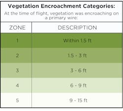
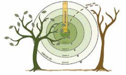
Critical to DTE, the survey identified all vegetation encroaching or tall enough to strike its conductors, providing a comprehensive and detailed inventory of the project area’s vegetation threats. These threats were classified according to their proximity to the nearest primary wire as well as by their potential to fall in or overhang above the wire by up to 15 ft (4.6 m).
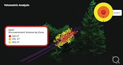
The utility also received a full inventory of vegetation encroachment by volume. The encroachment was broken down into priority zones to better assess each circuit’s immediate needs. In addition to vegetation encroachment data, the survey also provided critical information like rectified pole and span locations and a detailed clearance analysis.
Following completion of the survey, DTE conducted spot checks of 200 locations to assess the accuracy of the LiDAR data. Encroachments measured in the survey were accurate to within 4 inches (102 mm), a level of accuracy previously unavailable to the utility. The spot checks also helped DTE and Quantum Spatial to identify the survey’s limitations and understand how best to use the data.
Volumetric Analysis
Though the results of the LiDAR survey were accurate when estimating encroachment to conductors, vegetative conditions in the area resulted in unique challenges. When producing canopy segmentation data, the survey struggled to identify codominant stems where one trunk may separate into multiple canopies. In addition to struggling with codominant stems, DTE found planning work based on only priority-zone threat levels did not provide enough context for planning the actual work needed for each tree canopy.
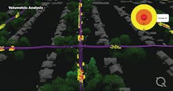
To provide further context, DTE turned to Quantum Spatial’s volumetric assessment to focus on severe encroachments and understand the volume of vegetation that needed to be removed per individual zone infraction. By relying on the volumetric analysis within each priority zone, as opposed to relying strictly on a LiDAR-based tree count, DTE was able to shift its focus to ensure it was making the most effective decisions when prioritizing assignments.
A Paradigm Shift
Prior to LiDAR, DTE’s service territory introduced a high level of uncertainty when managing bids from outside service providers. Because of the accessibility demands and scale of sensitive areas, the utility rarely can inspect potential encroachments comprehensively prior to routine trimming.
The character of the region’s geography encourages contractors to make opportunistic bids or forces contractors to build significant contingencies into their pricing. Because of the inherent unknowns in its territory, DTE was forced to concede these higher costs.
The new trove of data available to DTE brought about a fundamental shift in the bid negotiation process. With a standardized, quantified inventory of encroachments, the utility could level the playing field among vendors and drive competitive pricing. The new data was useful for managing time and equipment (T&E) contracts as well as negotiating fixed-bid contracts, as the LiDAR data enabled DTE to quantify precisely the work involved to each bidder.
Armed with precise data, DTE developed models to determine whether bid estimations matched the reality of the assignment. The utility trained its machine-learning algorithm, a linear regression model, by providing it with examples of circuits with known vendor bids.
As more information was provided to the model, it could estimate the cost of future contractor work by drawing correlations with historical data. Most importantly, the model could identify outlier circuits that may be overbid, empowering DTE employees to compare the bid price with the LiDAR survey.
Using a K-means clustering algorithm, the model grouped similar circuits together based on the structure of the LiDAR data. The K-means clustering model further enhanced the conclusions of the linear regression model, emphasizing those bids that did not align with historical performance and enabling DTE to negotiate pricing further, based on solid data.
Contract Costs
DTE put its LiDAR data to the test in a series of bid negotiations for both expedited and general maintenance trimming. In one instance, the LiDAR pricing model predicted the contractor line mile cost should be just 48% of current prices on a T&E contract. Using the model’s estimated bid, DTE provided an actionable target line mile cost to the contractor. The utility shared the LiDAR-based audit information with the contractor to show its current productivity was almost double that of the calculated run rate. This conversation led to the contractor’s cost falling about 30%.
One of the greatest successes of the LiDAR program was the ability to identify an area of unexpectedly severe vegetation encroachment relative to its anticipated maintenance cycle. Using the encroachment data derived from the LiDAR survey, DTE was able to expedite maintenance trimming in the area. The expedited maintenance trimming request went out with a firm fixed-price bid and covered a single substation in a highly sensitive community.
The utility received multiple bids that were higher than expected. Therefore, DTE used the LiDAR data to quantify the true work volume for the substation and, subsequently, the true work value of the project. The pricing model generated estimated bids for the assignment, and the utility ultimately saw a final price reduction of 28.6% for its expedited maintenance trimming request. These savings covered the entire cost of the Detroit LiDAR survey project.
Defining Bid Scope
In addition to ongoing and expedited 2019 projects, DTE applied its LiDAR survey data to its yearly contracting process for 2020. All bidders were provided with the LiDAR data results, which included a true and comprehensive assessment of the locations and amount of work that needed to be performed.
In previous years, DTE had observed an extremely high variance in bid prices between vendors and frequently received bids that did not align with the utility’s expected cost. The detailed LiDAR information brought contractors and DTE to a consensus, where DTE received total bid prices from all bidders that were within 5% of the utility’s anticipated 2020 cost.
Beginning the bid process with fundamentally accurate data and having less variance between bids provides a level playing field for contractors and DTE. This data also enables more reasonable expectations for bids from both parties moving forward.
Additionally, the utility was able to negotiate discrepancies on an individual circuit level between the predicted price and bid price based on the LiDAR and volumetric results, successfully driving down the final cost of the agreements even further.
Condition-Based Program
In addition to the trim contracting benefits, the LiDAR data enabled DTE to identify critical vegetation hotspots so it could proactively address situations that pose imminent outage threats and, in turn, extend the trim-cycle life of these circuits. Furthermore, the LiDAR data empowered DTE to identify areas where contractors failed to meet their trimming obligations. Multiyear LiDAR data collections over the same area will further enhance this capability as well as provide additional change-detection analytics, such as providing information about growth rates.
Ultimately, LiDAR data enabled DTE to make a program shift from cycle-based maintenance to condition-based maintenance. Making the shift to condition-based maintenance is a topic of interest for many utilities, as prioritizing and allocating trimming to be based on threat and need instead of a somewhat arbitrary timeline is logical.
That said, the shift requires time, logistical planning and change management, as it is a significant departure from how many utilities and trim contractors operate today. Most importantly to make the shift, utilities need to know exactly where vegetation threats are across their system and how to prioritize them, which is exactly what LiDAR surveys provide.
Benefits Beyond ROI
Following completion of the project, DTE worked with Quantum Spatial to conduct a thorough yet conservative cost-benefit analysis that included data points such as corridor miles, inspection frequency, average clearing cost per mile, system average interruption duration index and system average interruption frequency index.
The predicted ROI for the project area over a five-year cycle included both outage reduction and trim reduction as well as the overall optimization of inspections and trimming. The total ROI was 10.5 times DTE’s initial outlay. Since completing the original LiDAR survey in December 2018, DTE has commissioned additional surveys to capture other areas of its service territory. Based on the success of the program, the utility is considering expanding it on an executive level.
The impact of DTE’s LiDAR survey has extended beyond financial gain. Most importantly, the increased efficiency of the utility’s vegetation management program has led to improved public relations, as an overall decrease in outages has boosted customer satisfaction. The program’s deliberate targeting of vegetation also has led to a safer work environment for DTE employees and its contractors, as the targeted data enables field employees to limit the amount of time spent in sensitive neighborhoods.
In the short-term, DTE will continue to use volumetric data analytics to inform targeted trimming strategies, future vegetative growth and bid negotiation techniques. DTE also plans to explore other remote-sensing technologies to monitor vegetation control in more rural areas of its service territory. As the utility continues to perform cyclical LiDAR surveys over the next several years, new information will feed into its models to adapt and enhance a more comprehensive program, further honing its effectiveness.
About the Author
Craig Jackson
Craig Jackson is manager of forestry planning, auditing and herbicides at DTE Energy, where he is responsible for managing the utility’s tree trimming program. Jackson has worked at DTE for more than 14 years in a variety of project management, operations and supervisor roles. His education includes a BSME degree from Lawrence Technological University and a MBA degree from the University of Michigan. Additionally, Jackson is PMP certified and a Lean Six Sigma Black Belt.
A. J. Smith
A.J. Smith is regional forester for DTE Energy in Detroit, Michigan. He has led the utility vegetation management’s remote-sensing program since 2018. Smith earned his bachelor’s and master’s degrees in forestry from Michigan Technological University in 2013 and has been an International Society of Arboriculture Certified Arborist since 2015.
