Someone jokingly said a couple of years ago regarding the future of Amazon drone delivery: “After your first drone arrives, five others will arrive bearing items we think you might also like!” This was half a year before the U.S. Federal Aviation Administration (FAA) approved the first use of small unmanned aerial systems (sUAS), or drones, for commercial purposes. Soon many companies in the U.S. started exploring the possibility of using sUAS as part of their daily operations and filing for Section 333 exemptions with the FAA that would allow them to operate these devices legally.
Today, two common myths exist about sUAS. The first myth is associated with visual identification of sUAS as toys. They are fun to fly for any individual, and they can do some amazing things in the air, like flips and so forth. However, to Duke Energy, these devices are assets. Many of these platforms cost more than the trucks and other vehicles utility personnel use on a daily basis. The sUAS could help to perform operations and maintenance activities on the power system that would keep personnel out of harm’s way.
The second myth is sUAS are a new and emerging technology. The number of drone start-ups and the amount of venture capital recently invested in these companies is staggering. However, this technology has existed and the military has been using it successfully for decades, so there is hardly anything emerging about the underlying technology. However, what has been emerging is how the data from the sUAS payloads is processed and how the use of data analytics engines can streamline this process.
Three Pillars
There are three pillars of implementation of the sUAS as a technology. The first pillar is the safety aspect. In the electric utility business, safety is at the core of everything a utility does. Utility personnel ask these questions every day: How safe are we? What can we do to perform any task more safely? From the safety standpoint, the use of sUAS has numerous advantages over traditional methods.
The second pillar is operational excellence, which describes how the use of sUAS can result in better decision making. In some cases, it might take the sUAS longer to complete the task, but the additional data obtained during the mission can result in better decision making or provide insights not previously considered, or able to be considered, because of the lack of data.
The third pillar is the business case aspect that determines whether the particular use case can be cost-effectively achieved by doing the inspection with sUAS.
Use Cases
Duke Energy, with the assistance of Hunton & Williams LLP, applied for and, in mid-2015, received its first Section 333 exemption. Thereafter, Duke undertook its first pilot project, which consisted of a series of flights over the course of three weeks at the Marshall Steam station, located approximately 30 miles (48 km) north of Charlotte, North Carolina, U.S. Almost 20 use cases were tested during the pilot project: coal pile inspection and volume measurement, coal ash pond inspection, coal ash pond dam inspection, solar plant inspection, T&D line and pole inspection, industrial pile inspection, flu-gas-desulphurization stack inspection, and video and aerial imaging.
A majority of the current use cases associated with electric utilities relate to the inspection of transmission lines. However, in Duke Energy’s case, even though T&D line inspection was part of the sUAS pilot project, it was not considered the primary use case because Duke Energy has its own aviation department and helicopters that perform its transmission line inspections.
From the standpoint of making a business case for the transmission line inspection, a helicopter can fly and inspect between 400 miles and 440 miles (644 km and 708 km) per six-hour flight, and the associated cost can be between US$1,300 and $2,000 per hour, depending on the payload the helicopter carries. Inspection with sUAS, which requires a two-man team operating the device within visual line of sight, can probably be performed in the range of 0.2 mph to 0.4 mph (0.32 kmph to 0.64 kmph). The cost of this operation varies between $2,000 and $6,000 per day for the two-man team. Therefore, from the standpoint of operational efficiencies and making a business case, transmission line inspection is probably the most challenging in the current regulatory and technological environment.
Pilot Project
In executing the sUAS pilot project, Duke Energy collaborated with several partners and tested multiple platforms. The project participants included the Mid-Atlantic Aviation Partnership, one of the six national UAS test centers, HAZON Solutions and AeroVironment Inc. The platforms used were the Aeyron SkyRanger, DJI Inspire, 3DRobotics X8+, DJI S1000, AeroVironment Shrike and AeroVironment Puma.
The first objective of the pilot project was to understand the capabilities of different vertical takeoff and landing (VTOL) sUAS platforms (quadcopter/hexacopter/octocopter), and to determine the minimum technical characteristics of certain payloads, such as electro-optical/infrared (EO/IR) cameras, required to achieve the desire data quality. Based on the high-definition pictures and videos obtained during the pilot project, the minimum requirement for the EO camera combo is 4k camera resolution with 30x zoom. The IR camera minimum requirements are 640x480 resolution with temperature measurement, thermal sensitivity of less than or equal to 0.08˚C, digital detail enhancement functionality, GPS tagging, and either built-in digital camera or integration with EO payload — for the visual and related thermal image to be saved simultaneously.
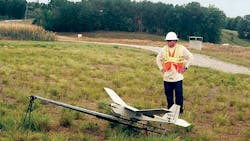
The second objective of the pilot project was to understand the capabilities of the fixed-wing platform called Puma from AeroVironment, along with advanced payloads such as light detection and ranging (LiDAR), multispectral camera and 24MP photogrammetry. Puma — one of the most widely used sUAS platforms by the U.S. military — is a fixed-wing platform with an approximately 9-ft (2.7-m) wingspan that can carry a basic EO/IR camera and more advanced payloads, such as LiDAR and a multispectral camera, and a 24MP photogrammetry camera. Given this platform can stay aloft for up to 2.5 to 3.5 hours (depending on the payload type) with a single battery as a power source, the amount of data collected and the area that can be covered during a mission is quite significant.
Coal Pile
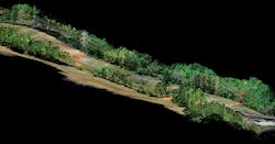
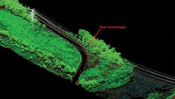
During the pilot project, a LiDAR camera was used during the coal pile inspection, coal pile volume measurement and transmission line inspection. The objectives of this part of the project were to understand the output data from this camera, how this camera compares to the LiDAR camera Duke Energy currently uses during its inspections with helicopters, and whether analytics applied to the output data could result in new insights.
The results from the pilot were encouraging:
• The LiDAR camera resolution was found to be in the 300-point-per-sq-m (ppsm) range to 800-ppsm range, which is significantly better than the 20-ppsm resolution traditionally achieved.
• Combining the images from the LiDAR camera with either a multispectral camera or a 24MP photogrammetry camera as well as with some sophisticated data analysis resulted in the creation of new data sets. Note that to achieve the maximum benefits from the outputs of different cameras, having 3-D visualization software is a must.
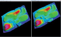
The objective of the part of the project associated with a 24MP photogrammetry camera was to understand if collecting data with this camera could create a 3-D model of any particular area. This was done by using the 3-D software with overlapping images taken during the flight. This particular payload was also used for coal pile volume measurement, coal ash pond inspection and transmission line inspection. The accuracy of the coal pile volume data measurement for two days compared with the records available at the time were within 5%, while the accuracy of volume difference between the two days was within 2.5%.
Vegetation Management
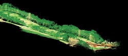
The AeroVironment analytical tools provided the distance measurement between the transmission lines and surrounding vegetation. In addition, the simulation tool also performed dead falling-tree analysis by providing the minimum distance between any tree in case of falling and the transmission line.
The objective of the part of the project associated with the multispectral camera was to understand the capabilities of the camera as well as to determine if the camera could recognize vegetation versus non-vegetation around the transmission lines.
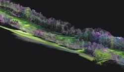
Using another analytical tool provided by AeroVironment, LiDAR images were fused with normalized difference vegetation index (NDVI) created with a multispectral camera. NDVI is normally used to distinguish between vegetation, soils, water and human-made materials that represent the field landscape. These images show healthy (green) versus non-healthy (orange) vegetation, which is an important and desired feature. Results show combined use of LiDAR, multispectral and the NDVI data produced the most accurate field models.
Moving forward, using this type of technology and applying the growth rates for different vegetation types, it will be possible to predict the tree-trimming patterns using condition-based models rather than time-based models.
Platform Contrasts
One of the lessons learned during the pilot project was the significant differences between the military-grade platforms and the typical commercial platforms, particularly in the level of security and privacy they offer, which is a function of the architecture of these devices. Two main components of sUAS rely on some type of communications: command and control, and video/data transmission. The majority of commercial sUAS use 2.4 GHz and 5.8 GHz to operate the sUAS and send the video. On the other hand, military-grade sUAS (like Shrike or Puma) currently use encryption in the form of secure data links like common data link, built-in validation function links or some other form.
Naturally, the unencrypted communications protocols are more susceptible to GPS spoofing, GPS signal jamming, malware-based cyber-attacks, electromagnetic pulse attacks and other types of cyber-hacking techniques. Given this shortcoming, Duke Energy expects to rely primarily on platforms with encryption on both command and control as well as video/data transfer as part of any future pilot projects and full-scale operations. Furthermore, given no security standard exists for the sUAS platforms, Duke Energy is investigating which entity should lead this effort, because it is of the utmost importance to have this standard written and implemented given the nature of the electric utility business.
Future Objectives
Moving forward, Duke Energy will complete its pilot project activities associated with sUAS with a few additional use cases, such as substation 3-D modeling, complete solar plant thermal inspection, and wind power farm video and thermal inspection. Additional research also is needed to understand how the video data obtained during the inspection can potentially be uploaded to a server for automated analysis, rather than constantly having someone go through all the video data and complete the inspection that way.
Another area of research that will be carried out is to understand how the data obtained during the inspection can be integrated with the existing systems, like GIS or others. In addition, determining the business cases for all of the use cases investigated up to this point and understanding the range of activities associated with the implementation of the sUAS across all Duke Energy businesses and how to execute those are the main activities in the nearest future.
sUAS definitely will have a major impact on the way utilities like Duke Energy do business in the future. However, ensuring all activities are executed safely is at the forefront of the implementation and integration of sUAS into the aviation department at Duke Energy.
Aleksandar Vukojević is the emerging technologies manager at Duke Energy. His primary duties involve developing, installing, testing and evaluating new technologies for Duke Energy’s electrical grid. In addition, he is responsible for the strategic roadmap for power grid devices at Duke Energy. He worked as a manager of smart grid distribution automation and technology at Baltimore Gas and Electric, lead power systems engineer for smart grid technologies at GE, field test engineer and transmission planning engineer at Georgia Power, and system protection and controls engineer at Baltimore Gas and Electric. He has BSEE and MSEE degrees from the Georgia Institute of Technology and an MBA degree from Robinson College of Business at Georgia State University. Currently, he is pursuing a Ph.D. degree in electrical engineering from the University of North Carolina at Charlotte.
