Electric utilities did not really begin the heavy use of aviation-based technology until after the Northeast blackout of 2003. Of course, we used aircraft throughout the industry, but not to the extent we do now. It took a mix of trees and power lines leaving about 50 million people in the dark for us to get serious about aircraft.
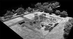
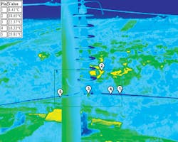
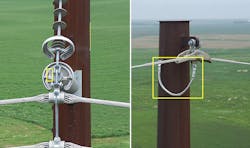
After the North American Electric Reliability Corporation (NERC) investigation of the blackout, utilities were required to inspect their entire transmission systems annually. With hundreds of thousands of miles of transmission lines, the only possible way to do this was with airborne inspections using imaging equipment such as light detection and ranging (LiDAR). From that point onward, aviation technology changed the average utility’s game plan in a big way.
Once these flying machines and their payloads started working in one part of the enterprise, interest went up throughout the organization. We found that applications developed for one purpose could be modified slightly and used for a whole new purpose. It also helped that pricing was dropping while sensor packages were increasing in capability, which, in turn, made using them more cost effective. As a result, airborne services are gaining traction as more utilities adopt maintenance practices, surveying tasks, inspections and other undertakings that require the unique abilities of fixed-wing aircraft, helicopters and drones.
Not Traditional
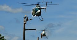
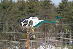
There are some interesting YouTube videos showing a technique known as short-hauling, or more correctly Class B HEC (Class B external load with human external cargo). In this procedure, a lineman is suspended in a harness from a line attached to the cargo hook of a helicopter. One video shows a lineman on the ground hooked up to a helicopter hovering overhead. After the lineman’s harness is secure, the helicopter gains altitude, and the lineman is whisked away to a transmission line high in the surrounding mountains. Once on station, the helio-lineman can work either from the harness or transfer to the structure, depending on the assignment.
Another video shows a lineman on a ladder, with the lineman and the ladder attached to the long line of the helicopter. After the harness is checked, the helicopter lifts them off the ground and flies them to a transmission structure. The lineman lands the ladder over the tower’s crossarm, disconnects the ladder and his lanyard from the long line, and works from the ladder.
Longlining has been around for several years, but it has been getting a great deal of attention lately. While longlining is not for the faint-hearted, this method has been proving its worth to many operators supporting transmission line projects. The YouTube page includes several videos from utilities around North America such as Bonneville Power Administration, Western Area Power Administration, Sacramento Municipal Utility District, BC Hydro and others. These are just a few of the many utilities that have recognized the value of this airborne technique. Longlining is particularly valuable in environmentally protected lands, rough terrain, wetlands and other areas that can’t be disrupted.
In addition, outages for maintenance work are becoming almost impossible to schedule, so techniques such as long-lining that allow for working live are doubly important.
Dan Vega, director of business development and marketing for PLH Group, says the Federal Aviation Administration (FAA) defines this method as Class B rotorcraft external load. The operator must be certified by the FAA to conduct these types of operations. The process is made attractive to operators by a special back-up device designed to prevent inadvertent release from the aircraft. Another safety feature of this technique is that the helicopter is oriented high above all obstructions, which keeps the turning rotors a substantial distance from conductors, wires and structures.
“This process increased availability of the helicopter to deliver persons and equipment to work locations because of the aircraft being able to nose-in to the wind,” Vega said. “This is normally a limitation in other methods that require the aircraft to stay parallel to the work location, and thus restricted by wind direction and speed.”
Smile, You’re on Camera
Photogrammetry has been around since the start of photography. It really got a boost when cameras became airborne. The PBS series Nova ran a story about overlapping photographs during World War II using 3-D photos to find camouflaged installations. After the war ended, stereophotogrammetry moved to commercial applications and became a useful adaptation for electric utilities called PhoDAR, or fodar. PhoDAR is an acronym for photogrammetric detection and ranging, but fodar is not an acronym.
According to Fairbanks Fodar, the originator of the term, it is portmanteau of “foto” and “LiDAR.” Fairbanks Fodar says the fodar process is distinguished from traditional photogrammetry by the use of structure from motion (SfM) algorithms in its software, and its use of survey-grade GPS to locate photos within 10 cm and create maps with accuracies of <30 cm. Whichever name is used, this multi-ray photogrammetric technique for making high-resolution 3-D images of the ground surface is competition for LiDAR.
PhoDAR is being offered by many service providers, including WIRE Services, SPAR3D, GEOPRO, Esri and NM Group. According to providers, the cost of PhoDAR is about 20% that of LiDAR (depending on the software and cameras used), but its drawback is that it can’t see through foliage like LiDAR.
Jim Dow, CEO of Aerotec, has been using fodar (recently) and LiDAR (for many years) for commercial transmission vegetation management projects. “In some applications, fodar is faster, cheaper and better (such as transmission vegetation management). Fodar can replace LiDAR,” Dow said. “But for other applications (transmission engineering design), LiDAR retains its leading position because of the requirement for a finer granularity of the data needed to identify/locate things like conductor attachment points. Fodar is limited to the finite size of the camera’s pixels, but it’s great for right-of-way patrol, change detection and encroachment detection.
“Fodar presents reality illustrations because it’s based on pictures. LiDAR presents reality through precise geometry because it’s based on points,” Dow said. “LiDAR remains more (absolutely) accurate than fodar, although we have been almost able to duplicate LiDAR accuracy with fodar. Fodar (through current innovations in 3-D model construction/display capabilities) allows users to augment the reality of their fodar-rendered 3-D point cloud scenes by adding derived (constructed geometric objects) information. Now the utility forester can actually see (and visualize) the effects of his clearance criteria. Before, the utility forester really had no idea what impacts he was making when he chose a set of clearance criteria. It was truly a WAG and everybody knew it. Conclusion: Fodar allows us to move toward augmented reality. It’s just like the Pokémon phenomena.”
Combining Applications
LiDAR has been used successfully to map transmission lines, and when combined with line design software such as PLS-CADD, the combination provides models of those lines for thermal rating issues. With this approach, utilities can identify transmission line concerns such as clearance issues, vegetation encroachments, actual line ratings and structural problems. But what about the distribution system? Utilities have been using LiDAR data on their distribution circuits but not to the extent they have been using it on their transmission systems.
“Until UAVs, it wasn’t really practical to LiDAR distribution lines because of the size of traditional LiDAR aerial platforms,” said Otto J. Lynch, vice president of Power Line Systems Inc. “But, of course, UAVs are a game changer. With the ongoing efforts to storm harden their distribution systems, utilities can now use lower-flying UAVs in more populated areas. This allows them to accurately survey and model their distribution systems in PLS-CADD to selectively identify vegetation encroachments and danger trees considering the full wire movement envelope. From a structural standpoint, this lets the utility determine what poles need to be upgraded or replaced so they don’t break during the next wind or ice storm.”
Another combined application along these lines has been the combining of LiDAR and the PLS-CADD process with spectro-optical reflectance indexes to determine the health of vegetation on the right-of-way. One popular index is the normalized difference vegetation index (NDVI).
Several years ago, some service providers combined LiDAR and plant NDVI measurements to identify dangerous vegetation and the health of the vegetation. Tall, sick trees can become falling objects that affect transmission lines, since most of the today’s vegetation-related outages come from outside the right-of-way. Lynch says this process results in the generation of a great deal of data because every tree, branch and leaf LiDAR point represents a unique violation. To help service providers and utilities turn this massive data gathering into actual usable information, PLS-CADD has developed a “Work Site Feature” that will identify thousands of violations in a cluster and develop a single work site with the parameters of the entire work site, such as area, height and geographical coordinates. This makes it easy to send a vegetation crew to a single location with clear and concise instructions.
POWER Engineers has combined the talents of its visualization, mapping and analysis departments to use UASs for collecting video, photos and data for use in its state-of-the-art 3-D terrain and tower modeling and visualizations. POWER Engineers uses two types of drones to fly missions, fixed-wing and rotorcraft. The fixed-wing system can fly for up to 40 minutes collecting GIS data, aerial images and terrain models. The rotorcraft is capable of carrying high-resolution photography and video equipment that can capture data from nearly any angle. The rotorcraft can hover in one place and fly with extreme precision, making it possible to model structures such as lattice towers.
POWER used this consortium of skills to demonstrate different development scenarios for a vacant piece of property near its offices.
“The project was used specifically to demonstrate the accuracy of UASs for the visualization field. Aerial visualizations have traditionally been accomplished with helicopters,” said Jason Pfaff, POWER’s visualization department manager. “However, helicopters are restricted from flying below the 400-ft FAA hard deck. UAVs, on the other hand, typically operate below 400 ft — allowing visualization specialists to get closer to the action, obtain higher-resolution data and ultimately produce better visualization products.”
Aaron Ames, POWER’s mapping and analysis department manager, expanded on the project, “Flight planning was accomplished with Google Earth and uploaded into POWER’s Inspire 1 Pro. The rotorcraft followed its preprogrammed flight to collect high-resolution imagery and video of the proposed project location. Geolocated camera matching was accomplished by extracting EXIF data from the UAS and loading it into 3-D programs. This allowed visualization specialists to combine field cameras with virtual cameras. CAD designs of the proposed projects were uploaded into the 3-D program and combined with an accurate sun system to create a very accurate and highly realistic look into the future.”
These technologies are evolving rapidly, and it’s hard work to stay up with the latest changes to ensure the best results are being obtained.
Expanding Utilization
NM Group reported that new small-platform LiDAR scanners developed for drones are being used on helicopters, enabling data to be captured at the same time as existing budgeted visual line patrol flights. This provides the utility with more data from each flight. High-altitude focal plane array LiDAR (Geiger-mode, single photon, flash) is also changing imaging surveys. It scans a 3-mile swath of surface area at about 300 mph, reducing costs and covering more miles of transmission lines in a much shorter time.
The bottom line is airborne applications are changing how utilities perform workflows and, in the process, are maximizing efficiencies and providing a safer work environment. Technology never stops improving or moving forward, and our challenge is to adapt to this new airborne opportunity.
Editor’s note: To see a video of POWER Engineers’ 3-D visualization using a drone, visit https://youtu.be/XqDpz-FkPpQ.
About the Author
Gene Wolf
Technical Editor
Gene Wolf has been designing and building substations and other high technology facilities for over 32 years. He received his BSEE from Wichita State University. He received his MSEE from New Mexico State University. He is a registered professional engineer in the states of California and New Mexico. He started his career as a substation engineer for Kansas Gas and Electric, retired as the Principal Engineer of Stations for Public Service Company of New Mexico recently, and founded Lone Wolf Engineering, LLC an engineering consulting company.
Gene is widely recognized as a technical leader in the electric power industry. Gene is a fellow of the IEEE. He is the former Chairman of the IEEE PES T&D Committee. He has held the position of the Chairman of the HVDC & FACTS Subcommittee and membership in many T&D working groups. Gene is also active in renewable energy. He sponsored the formation of the “Integration of Renewable Energy into the Transmission & Distribution Grids” subcommittee and the “Intelligent Grid Transmission and Distribution” subcommittee within the Transmission and Distribution committee.
