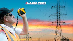
Measure More. Move Less. Get Home Safely.
Key Highlights
- Reduce unnecessary field exposure by capturing measurements from fewer positions
- Improve consistency of utility measurement data across all field crews
- Accelerate outage response with faster, more efficient field measurement workflows
- Strengthen confidence in critical clearance and structure measurements at first capture
- Enable connected utility workflows with seamless GIS and asset system integration

Utility field work has never been about ideal conditions. Right-of-way access, energized infrastructure, terrain that never cooperates, and timelines don’t leave much room for inefficiency. The measurement itself is rarely the challenge, it’s everything required to get into position to take it. Most crews already know this firsthand.
A clear shot on a span can mean walking the corridor. Verifying clearance can mean multiple setups. Confirming structure or conductor details can mean climbing, crossing under lines, or pushing through brush just to get line of sight.
Nothing about that is new. It’s part of the job. But over time, it adds up: time, fatigue, and exposure accumulate across inspections, storm response, and capital work where volume and speed are constant pressures.
At the same time, expectations for more output, faster turnaround, higher accuracy, and fewer people in the field keep rising. That combination is already reshaping how measurement work gets done. The shift isn’t about doing something different, it’s about removing what doesn’t need to happen twice.
Access Is What Slows the Job Down.
In utility environments, measurement rarely creates delays. Meanwhile, access does.
Getting into position along a corridor, working through uneven or obstructed rights-of-way, maintaining safe clearances around energized equipment, moving back and forth to confirm conductor height, sag, or structure alignment, each position takes time, each movement adds complexity to an already full workflow.
In planned work, each reposition shows up as reduced productivity. In storm response, it shows up as slower restoration. In both cases, it increases time spent in environments where exposure is already part of the equation.
As system demands grow and field resources stay tight, reducing unnecessary movement stops being a convenience and becomes a requirement.
Field Conditions Don’t Cooperate.
There’s no controlled environment in utility work. Crews are operating under live lines, through dense vegetation, across waterways, along roadways, and in weather that can shift mid-task. On top of this, visibility changes, terrain changes, targets aren’t always clean or isolated.
Workflows need to move toward a more practical goal: capturing complete measurement data from fewer positions.
Instead of repeated movement between structures or returning to confirm readings, crews are leaning toward collecting distance, height, slope, and positional data from a single setup.
The result is not less fieldwork, but less repetition within it, meaning fewer back-and-forth movements in difficult terrain. For supervisors, it means more consistent field data with fewer gaps requiring follow-up.
Confidence Starts at the First Measurement.
Measurement data accuracy carries downstream consequences. Small errors don’t stay small for long. Clearance, span, and structure data feeds directly into design decisions, outage planning, and system reliability work. When targeting is off, rework follows.
The challenge is rarely the data collection itself; it’s correct target identification in complex visual environments. When data is captured correctly the first time, everything downstream moves cleaner.
When the correct point is established, onboard calculation tools allow crews to capture the necessary measurement data directly in the field, removing reliance of off-site processing.
The result? Reliable data the moment it’s collected.
Field Data Has to Move With the Work.
Utility operations are no longer isolated between field and office; they are connected systems. This requires measurement data to move cleanly into GIS platforms, asset systems, engineering tools, and outage workflows without added friction.
With dual-mode wireless connectivity, field measurements can transfer directly into mobile devices and utility applications, reducing or eliminating manual transcription once crews return. This matters less in theory and more in practice with fewer entry errors, faster validation, and less time spent between field collection and actual use. In outage environments or time-sensitive maintenance work, that difference directly affects turnaround time.
Corridors Don’t Behave Like Straight Lines.
T&D corridors are not simple point-to-point environments. They stretch across uneven terrain, variable elevations, and long spans where structure relationships matter as much as individual measurements.
This often means multiple setups just to build a complete picture of what’s happening across a section of line. When distance, vertical angle, and directional information are captured together from a single position, crews can establish that spatial context without needing to constantly move between points.
Instead of stitching together measurements across multiple locations, more of the corridor is understood from fewer setups. This becomes especially useful in long-span transmission work or restricted access areas where repositioning is time-consuming or adds unnecessary exposure.
Fewer setups mean less disruption in the workflow and more complete data before leaving the site.
What Actually Changes in the Field.
When viewed operationally, the impact is straightforward:
- Less time spent repositioning for repeat measurements
- Fewer return trips to confirm field data
- More consistent information flowing from field to office systems
- Faster progression from inspection or outage response to resolution
More importantly, it reduces unnecessary entry into areas where exposure can be minimized. The goal isn’t to remove field work. It’s to make it more controlled, efficient, and deliberate.
For crews, that means less fatigue at the end of the day. For utilities, it means more consistent execution across teams and projects. For both, it strengthens safety margins by reducing rework and repeat exposure in the field.
Built Around Utility Field Reality
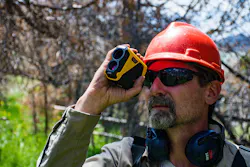
The TruPulse® i-Series from Laser Tech (LTI), is designed for the realities of utility field work. Combining improved measurement accuracy, enhanced targeting performance, rugged waterproof construction, and streamlined connectivity to support real field workflows in transmission and distribution environments.
For teams that need expanded spatial capability, the TruPulse® 360i integrates compass-based positioning, allowing distance, inclination, and azimuth to be captured together from a single setup point.
In long-span transmission work, that reduces the need for repeated repositioning across difficult terrain while still maintaining complete measurement coverage.
At its core, the objective is simple: Capture what you need from where you already are.
Instead of taking more steps, take better ones. In utility field work, efficiency isn’t just about speed. Recognizing that every step carries weight and removing whatever doesn’t add value is just as important, if not more important.