Real-World Wildfire Mitigation From Space
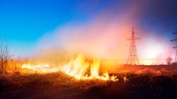
Wildfire season now seems to last all year, without much of an off-season for recovery. Wildfires around the world can be summed up in two words: “escalating” and “devastating.” Advancing climate change, with its storms and droughts, supports rapid forest growth, which leads to dry and starving trees and builds an abundant source of flammable kindling.
The impact of wildfires is heartbreaking:
- Lives lost — In the last two decades, wildfires have been responsible for thousands of lives lost around the world.
- Acres burned — In 2021, wildfires burned 7 million acres (2.8 million hectares) of land in the U.S., according to the National Centers for Environmental Information.
- Fiscal impact — It is not uncommon for utilities to face billions of dollars in wildfire costs, including damage to infrastructure and resources needed for restoration.
- Liability — In many cases, insurance is either incomplete or simply unavailable. Even with insurance, utilities can still be held liable for massive amounts of money and even criminal charges.
Regulators now require utilities to have wildfire mitigation plans in place, and many utilities are opting for rolling blackouts or public safety power shutoffs, which come with their own host of reliability and customer satisfaction problems.
Electricity infrastructure is becoming more and more crucial as society demands the clean energy potential of electricity for vehicles, homes and factories. At the same time, utility regulators are requiring more scrutiny of utilities’ vegetation management practices while the utilities themselves struggle with workforce shortages, a brain drain of experienced retirees and rising labor costs.
Intelligent Vegetation Management
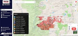
As a rural electric cooperative in Colorado’s mountainous northern front range, United Power, Inc. must be strategic with its budgets and resources. Its Mountain District covers approximately 400 sq miles (1036 sq km), all of which are in a high-risk wildfire zone. Rugged terrain, high winds, winter storms and densely forested areas increase the coop’s fire danger. With a relatively small investment in technology, it has yielded large returns in system resilience and reliability while conserving budget, staff, and resources. Moreover, the technology has helped the utility to manage wildfire threats.
“I’m able to use our budget and strategically remove vegetation where we have the greatest risk of a wildfire and track cycle trims,” said Holly Woodings, mountain area manager at United Power. “With satellites and AI, we can remove a hazard tree before it causes a power outage. All it takes is one dry, windy day and one tree to create a natural disaster.”
How Innovation Fights Wildfires
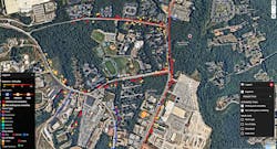
Technology innovation is a juggernaut in this world and above it, as well. Specifically, satellite technology has come a long way since 1957’s Sputnik. About 1000 new satellites now go up each year, offering seamless accessibility to Earth images. They can assess as many as 10,000 line miles (16,093 line km) per day, and imaging advancements now offer multispectral and even hyperspectral imaging along with synthetic aperture radar (SAR) that detects far more than the human
eye. Image resolution has advanced from 88 yards to 12 inches (30 cm), with 4-inch (10-cm) resolutions almost ready for orbit.
With substantial improvements in computing, artificial intelligence and machine learning, these high-resolution images yield astonishing data about the state of wildland vegetation. The red-edge band of the spectrum detects hazard trees with declining health, based on dryness of vegetation. It also measures the chlorophyll and moisture content of all vegetation, identifies species and gauges soil conditions.
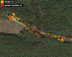
By taking on the data collection and analysis, these AI systems free up their human managers to focus on matters of evaluation and priority. The enhanced situational awareness helps vegetation managers to plan quickly, restore safely and communicate efficiently.
Data Drives Wildfire Planning
With the abundance of data and insights now available through modern satellites and AI, they must be incorporated into each of the three phases of wildfire risk mitigation:
- Prevention — The adage “prevention is the best medicine” is twice as true with wildfires. It may be impossible to stop a natural disaster, but most wildfires are caused by people, and one of the leading drivers is utility related. For prevention, utilities need to apply all their data to gauge the key ignition causes: vegetation connecting with a power line and failed equipment. This means constant reevaluation of the vegetation management strategy to understand where to harden.
- Detection — When disaster strikes, utilities must know at the earliest possible moment. This may be with increased inspections, automated remote sensing and situational action plans. Utilities also need current, accurate data about weather patterns and insights on potential spread to set up an emergency response.
- Response — Boots on the ground get the power back on for the community as fast as possible. The data guides those boots to the highest priority locations with real-time visualization of the damage. Intelligent vegetation management systems also can alert crews to terrain anomalies and even recommend the necessary equipment. Every second counts in this phase. Homes, businesses, hospitals, prisons, schools and other critical assets should not be without power longer than is absolutely necessary.
Get Ahead Of Wildfire Risk
There is no question that wildfire mitigation is a top priority for utilities around the world. It is getting significant funding and is held under a microscope by the public. With the right mix of processes, technology, people and data, utilities can reduce wildfire risk drastically and offer safe, reliable power to the communities they serve.
United Power’s Holly Woodings sums up the advantage she sees in applying advanced satellite and AI technology to prevent wildfires: “Being proactive is extremely important when you’re mitigating risk.”
ABHISHEK VINOD SINGH ([email protected]) is CEO and cofounder of AiDash. An alumnus of I.I.T. Kanpur, Singh worked with many IT companies prior to starting and growing a series of successful tech businesses including DbyDx Software & Edureka. He is based in Santa Clara, California.
About the Author
Abhishek Singh
Abhishek Vinod Singh ([email protected]) is CEO and cofounder of AiDash. An alumnus of I.I.T. Kanpur, Abhishek worked with many IT companies prior to starting and growing a series of successful tech businesses including DbyDx Software & Edureka. He is based in Santa Clara, California.