The Utility Vegetation Management (UVM) industry is evolving at a rapid pace as emerging technologies such as LiDAR, workflow systems and satellite imagery are revolutionizing the tasks that are executed every day. The typical workflow consisting of manual inspections and data collection are becoming more automated, providing UVM managers with data that they can trust and leverage to increase reliability, improve efficiency, and obtain a higher ROI on their vegetation-related O&M expenses.
These strides in innovative technology are growing at an exponential rate, and as technology expands with advances in Artificial Intelligence, Machine Learning and UAVs- it's easy to be left wondering where to start exploring what works best for your system. While the practice of using networks of ground-based sensors and aerial sensors such as drones or aerial LiDAR to collect data has existed for decades, geospatial data technology sourced from satellites has proved to be an emerging and successful option.
Undeniably, Satellite and LiDAR are the two most common technologies, and both have proved valuable to utilities as innovation has allowed collection of information with greater accuracy, depth, and contextual detail across large areas. However, decision makers are often faced with a more practical question - Which technology should I choose?
In this article, we’ll dive deep into the points that make a satellite-driven solution the choice of the future while comparing the technology to LiDAR.
Choosing the Right Technology is Key for an Efficient Vegetation Management Program
Utility Vegetation Management is a complex exercise beginning with inspecting and analyzing data to determining work types such as IVM (Integrated Vegetation Management), Hazard Tree Mitigation programs, Wildfire Mitigation and foundational Cycle Plans. Once an analysis is performed, the juggling of internal resources and external contractors adds a layer of workflow management, all while still maintaining regulatory compliance and preparation for disaster events such as storms and wildfires.
Each of these components require planning, time, and effort from your resources. However, technology has pathways to automate and streamline many of these tasks. A crucial goal to identify during an exploration of remote sensing platforms is not only determining what data points you’re trying to capture, but what can that data automate & support for you?
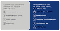
When looking at both LiDAR and Satellite as solutions for your system, don’t miss the opportunity to pair with a technology platform that can translate your data into actionable solutions. AI (Artificial Intelligence) models can take critical metrics such as your historical outages, customer counts, tree health, and many others to help automate your vegetation work planning. Beyond planning, a valuable remote sensing solution should not stop at just gathering insights of your system, but also help with the execution and validation of your work.
Artificial Intelligence has the power to learn from the data it's been given and look for items such as clearances on your system - not only before work has begun, but after it's been completed to verify it was done to specifications. This function can revolutionize the way utilities perform work validation and verification, saving time & money, and allowing resources to focus their efforts on reliability driven initiatives such as hazard tree mitigation and storm hardening.
8 Parameters that Matter: The Emergence of Satellite over LiDAR
LiDAR (Light Detection and Ranging) is a remote sensing method that emits light from a fast firing laser sensor and collects the reflection to determine points and distances from the area in its target. The sensor is typically aerial or terrestrial, requiring an external platform such as a fixed wing aircraft, helicopter, or UAV (drone). Its strength lies in measurement accuracy and detail, but its weakness lies in the external platform required to capture it.
Satellites offer a 360-degree picture of the Earth without the need for any external platform allowing for consistent availability, along with historical data to see into the past. Technology such as stereoscopic imagery (taking multiple images of the same area from two different points in orbit) and multispectral imagery (measuring light in multiple bands that the human eye cannot see) provide a huge volume of geospatial information in a short duration. Thanks to the easy access and availability of such data, satellite imagery enables deeper and more regular vegetation management intelligence, including change detection.
A breakdown comparison of these two technologies can help utilities decide what’s better. Let’s dive in:
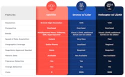
1. Speed of data acquisition – LiDAR systems can be airborne or terrestrial. Airborne LiDAR sensors are typically installed on a drone or a helicopter, whereas terrestrial LiDAR sensors are mounted on moving vehicles or tripods. As a result, the imagery and data captured via LiDAR only show a data set from a single point in time. On the other hand, satellites can revisit the same point multiple times per day regardless of imaging conditions. The advantages with satellite come via improved speed, frequency, and accuracy of imagery which all help to create cost-effective monitoring solutions.
2. Geographic coverage – Satellites can cover a massive area in one shot, almost the entire planet for that matter. For UVM stakeholders, it facilitates monitoring of their entire T&D network remotely. LiDAR UAVs and aircraft can only cover small portions of their networks, eventually costing more time, money, and effort.
3. Weather conditions – LiDAR works by bouncing laser beams off surrounding objects and collecting the reflection. While LiDAR can provide an accurate model on a clear day, it cannot see in situations such as storms, fog, or inclement weather. Satellites can utilize SAR (Synthetic Aperture Radar) to pierce through night or bad weather to capture the imagery below which can be crucial in a major storm response situation.
4. Change detection – Information on how a selected area has changed between two or more time periods is critical for evaluating vegetation before analyzing a work plan. As LiDAR requires an external platform to capture its data each time, it has limited value in spotting vegetation change due to acquisition gaps. In contrast, utilities can access historic data using satellite imagery. It can be used to automate the classification and locations of vegetation into specific categories and predict future growth models. Change dynamics analysis’s in imagery can automate evaluation from past changes in relation to the present, making change detection accurate.
5. Cost – Vegetation management is often the single largest line item in utility O&M budgets. The costs of flying drones and helicopters with LiDAR is very high and the process is tedious. From regulatory compliances to operational challenges, the cost keeps multiplying. On the other hand, satellite data is comparatively cheaper. What’s more? Historic satellite data is available for free. It allows users to compare changes in the surface of the Earth through decades at no cost. With satellites as opposed to drones and helicopters, users are getting the sweep of history instead of just a snapshot, for a cost that is way cheaper than LiDAR data. In the coming years, satellite data is only going to get better in quality and more frequent, making it more cost-effective and accessible.
6. Regulatory compliance – Regulatory approval is an important factor to consider with LiDAR operations, as many local governments have ordinances and regulations for flying drones and aircraft that can prevent or slow data acquisition. In comparison, satellites are readily available without requiring any regulatory approval to capture imagery.
7. Clearance detection - In addition change detection, satellites are also capable of detecting & modeling vegetation clearance quickly. Utilities can leverage this advantage to obtain insights of the vegetation within their proposed cycle plan, and then obtain new imagery to verify work has been completed to specifications- automating the work verification process. Beyond the efficiency of this advantage, AI models can leverage the multispectral band of imagery to determine factors like tree health, chlorophyl content and moisture & soil conditions by utilizing the near-red spectrum bands (which human eyes cannot perceive) to help identify potential hazard trees & wildfire risk. In comparison, LiDAR results can take weeks to years to be ready to be acted upon. By the time reports are generated with LiDAR, the data may already be outdated, requiring the process to be immediately repeated.
8. Operational challenges - The price of utilizing LiDAR data does not just involve acquisition costs. Following a LiDAR data capture, the data must then be processed by analysts to yield any vegetation insights for which it was gathered. Aerial acquisition involves an inherit safety risk due to the nature of flying closely over conductors, while satellites face neither of these challenges.
AiDash Intelligent Vegetation Management System (IVMS) is one such satellite and AI-powered solution that is already transforming vegetation management for your peers by enabling data-driven decision-making to achieve dramatic cost reductions and improving reliability. AiDash IVMS is the world’s only vegetation management system deployed at scale for several Fortune 500 utilities and cooperatives in the US, UK and Australia. If you want to save 20% in O&M costs and improve reliability by 15% with AiDash IVMS, feel free to contact us at [email protected].
Sponsored by: