Did you know wildfires burn an average of 5 million acres of land every year in the US? As wildfires continue to blaze out of control, there's so much at stake. From human lives lost and properties burned to utilities teetering on the brink of bankruptcy, wildfires can cost billions of dollars of losses and liabilities. Listen to this article.
Despite all this, Wildland Urban Interface (WUI) areas continue to grow by approximately 2 million acres per year. Let's also not negate the impact of climate change, that's causing wildfires to grow feral in intensity and frequency. According to the US Drought Monitor, 90% of the West is either abnormally dry or in a drought.
Wildfires vs. Electric Utilities: Traditional Approaches to Wildfire Mitigation
Electric utilities are faced with a complicated and staggering challenge. Many deadly wildfires have been caused due to faulty electrical equipment or downed power lines in the recent past. According to CPUC, powerline fires are on average 10X larger than fires from other causes. To prevent this, utilities have to resort to Public Safety Power Shutoffs (PSPSs) or rolling blackouts, a move that has further irked customers. Escalating costs and low reliability have hit the utility industry hard. What's worse? The lack of proper wildfire mitigation strategies has posed an enormous risk of survival for large and small power utilities across the country.
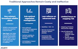
Traditional approaches to wildfire mitigation have proved to be costly and ineffective. Whether they are due to non-existent formalized wildfire plans or the limited focus on risk mapping, utilities have faltered at many fronts.
Using Satellites and Artificial Intelligence for Wildfire Mitigation
Technological advancements and pathbreaking innovations have ushered in a new era of Earth observation, making satellites more relevant and accessible to businesses. It is estimated that nearly 10,000 satellites will be launched between 2019 and 2028.
In addition to its massive scalability potential, satellites allow historical change detection, identification of vegetation densities and fuel load, and remote monitoring and surveying capabilities like none other. On the other hand, SAR-equipped satellites are light and weather independent and can detect the tiniest encroachments and sparks from up in space.
Satellite data processing has become easy with the advancements in Artificial Intelligence and Machine Learning. Data scientists are developing new and innovative AI models every day that are proving instrumental in applications across industries. One such use case is wildfire mitigation for electric utilities.
AiDash, a San Francisco Bay Area-based leading satellite analytics company, is working with several Fortune 500 companies to enable them with satellite and AI-powered risk mitigation capabilities. AiDash Intelligent Vegetation Management System (IVMS) is successfully helping utilities in identifying vegetation risks, hazard tree detection and more.
A glimpse into Avista’s Journey with AiDash
Avista Corp. is an energy company involved in the production, transmission and distribution of energy as well as other energy-related businesses. Avista Utilities is the operating division that provides electric service to 400,000 customers and natural gas to 367,000 customers. Its service territory covers 30,000 square miles in eastern Washington, northern Idaho and parts of southern and eastern Oregon, with a population of 1.7 million.
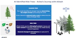
Avista has partnered with AiDash to deploy its satellite-powered product - Intelligent Vegetation Management System (IVMS) - for hazard tree and encroachment management as part of their wildfire resiliency plan.
“The ability to image our entire system and to know everything all at once – that is incredibly powerful, to begin with. AiDash Intelligent Vegetation Management System allows us to run reports, forecast our plan and include our budgetary information. This is a powerful platform that will help us differentiate between herbicide program, our encroachment program and then our risk tree program,” said David James, Wildfire Resiliency Plan Manager at Avista.
Want to know more about how satellite analytics can enable utilities in wildfire risk mitigation? Here's an insightful webinar by David James, Wildfire Resiliency Plan Manager at Avista and Bradley Smith, Sr Director, Operations & Sales at AiDash, that provides you a detailed overview of the topic.
Sponsored by:


