When a tree falls on a transmission line, it’s not just the resulting outage that a utility needs to worry about. Vegetation managers must anticipate this risk and have a mitigation plan in place that complies with industry standards.
After such an incident occurs, the utility will need to prove that the accident was unavoidable and happened through no fault of their own. They may need to prove that they met all pruning specifications for at-risk trees in the area. They may also need to show that they have assessed risk on trees in the area. Federal agencies and organizations such as the North American Electric Reliability Corporation (NERC) may ask for documentation to prove that all preventative measures were taken.
Trees are the leading cause of power outages for electric utilities, posing a threat to the 200,000 miles of transmission lines running throughout the United States. A single regional utility may be responsible for thousands of miles of transmission corridors, yet they have no way to patrol these areas every single day.
Electric utilities need solutions that support risk management and mitigation. However, they often lack access to all this data at once. Vegetation management crews may have to monitor corridors by ATV or through more expensive means, like helicopter. These costly and time-consuming methods may not even yield the results that utilities need to properly determine risk.
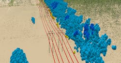
EagleView developed TreeRisk™ to help vegetation management crews overcome these challenges. TreeRisk enables vegetation managers to view encroachments, rank areas of highest risk, and schedule field crews only when they are needed. With high-resolution orthogonal and oblique aerial imagery, 3D point cloud models of the corridor, and a PDF mapbook for print or use on a mobile device, TreeRisk gives vegetation managers the information they need to make decisions.
How does this technology benefit electric utilities? Here’s why vegetation managers should add TreeRisk to their 2019 plans:
Make crucial decisions based on real-world views
While some datasets may provide information about transmission lines, they aren’t always easy to understand. Why not get a clear view of corridors as they actually exist?
TreeRisk displays transmission lines from a top-down perspective as well as oblique views at 45-degree angles. Real-world imagery and 3D point cloud models help utilities get the right view of their corridors without having to drive to remote locations.
Improve risk management
Vegetation managers need to anticipate risk, and they can’t do that without the right data. Patrolling the line may give them an idea of where risks might occur. However, this process is time-consuming and won’t enable them to truly prioritize areas in need of management.
With clear, risk-ranked maps, tree-trimming crews can more efficiently clear overgrowth and reduce risks by addressing the areas of greatest concern first. The TreeRisk mapbook is available as a PDF, which can be printed or accessed on a mobile device for use in the field.
See greater time and cost efficiency
Finally, what organization can’t bens.efit from saving time and reducing operations costs? TreeRisk enables vegetation managers to see which areas pose the most risk and schedule field crews with significant up-front savings.
The data included with TreeRisk can also support utilities should they ever be audited. With the mapbook, vegetation managers can prove that they have identified and resolved encroachment risks. This, in turn, can help utilities avoid regulatory fines as well as lost revenue from the effects of a fallen tree.
Learn more about what TreeRisk can do for your utility. See a sample mapbook.
Sponsored by:

