Leveraging Technology to Maintain and Protect
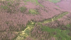
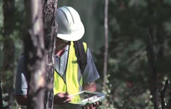
Dense, remote mountain forests damaged by prolonged droughts and beetle kill make the Colorado Rocky Mountains a tremendous challenge for transmission management. The immensity of that challenge was evident in early June 2013 as five wildfires raged across Colorado. Like other utilities in the area, Public Service Company of Colorado, an Xcel Energy company, was carefully monitoring its assets in the fire zones. Fortunately, Xcel Energy’s vegetation management group had spent the last six years preparing for days like these.
Xcel Energy began using geospatial and remote-sensing technologies, working with GeoDigital and other technology providers, to better protect its assets before the forest health issues had gained much attention from the public or press. Xcel Energy eventually expanded the use of remote-sensing technologies from the identification of imminent threats, such as trees growing too close to lines, to hazard-tree identification. In 2010, it began looking at how to expand the use of integrated systems to protect assets from wildfire.
The LiDAR Solution
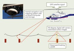
Xcel Energy first started testing the use of light detection and ranging (LiDAR) remote-sensing technology in an effort to identify and manage incompatible vegetation near thousands of miles of transmission lines throughout its eight-state service territory in 2007.
Similar to radar, LiDAR uses visible laser light in place of high-frequency electromagnetic pulses. Just as radar determines the range and altitude of objects, LiDAR can measure the distances and other properties of objects by illuminating them and analyzing the reflected light. LiDAR is often used to make high-resolution maps.
Xcel Energy first explored using LiDAR as a way to better ensure compliance with the North American Electric Reliability Corporation (NERC) FAC-003 Transmission Vegetation Management reliability standard, which went into effect in July 2007. This standard specifically applies to higher-voltage transmission lines. Xcel Energy had 5,700 miles (9,173 km) of transmission lines that fell under the scope of this standard — a distance that is a little more than driving from New York City to Los Angeles and back again.
Forest Health Issues Decline
In 2008, declining forest health issues across the western United States began to impact Xcel Energy’s electric distribution and transmission assets in Colorado significantly, specifically in the form of the mountain pine beetle epidemic.
To manage this unique threat, the utility, once again, turned to LiDAR and imagery for solutions. Trees that die as a result of beetle infestation will eventually fall, potentially striking power lines, causing outages and possibly wildfires. Large areas of beetle infestations greatly increase the potential for outages and fires.
Having devastated more than 4 million acres (1.6 million hectares) of forest, Colorado’s mountain pine beetle epidemic created an exponential increase in the number of hazard trees along Xcel Energy’s transmission system. In 2009, the company’s vegetation management team started surveying more than 650 miles (1,046 km) of higher-voltage transmission lines in areas susceptible to beetle kill, looking for hazard trees or any tree tall enough that could strike a power line if it fell.
Using the combination of LiDAR and near-infrared high-resolution imagery collected at the same time, Xcel Energy identified 263 hazard tree areas. By the end of 2009, it had removed 660 individual hazard trees, proving this combination of technology could be used to continue to manage the threat of hazard trees on transmission systems as the epidemic progressed. Since 2008, approximately 250,000 hazard trees have been mitigated from Xcel Energy’s electric distribution and transmission facilities in the mountain pine beetle epidemic area alone.
Clearion Software Systems Initiative
Because of the high degree of risk associated with managing hazard trees near power lines in an epidemic situation, Xcel Energy began looking for a software solution to manage the work more geospatially and precisely in the field that also would help to document property owner interactions. The system needed to be implemented quickly, be vendor hosted and have a high degree of functionality without integration with existing IT infrastructure. Xcel Energy found a solution and partner in Clearion Software.
Through the use of the Clearion Software system, the various deliverables from GeoDigital are fed into mobile devices that allow Xcel Energy contractors to go into the field to precisely locate threatening vegetation, mitigate the threat and document the work was completed. It also can document situations where a property owner might refuse or dispute the utility’s right to perform the work, which many times may be outside the easement bounds.
The implementation of the system allows contractors to plan, manage, execute and audit each step of the mitigation process, while improving documentation and communication between crews and management in the field. Integration with Panasonic H2 handheld mobile devices by vegetation management contractors in the field makes this solution rugged enough to operate reliably year-round in the harsh work environment encountered in much of the epidemic area.
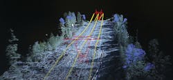
A few of the specific functions include the ability to walk a line remotely by viewing LiDAR data, the ability to more accurately build prescriptive maintenance plans and the integration of Panasonic H2 handheld global devices by vegetation management contractors in the field.
Proactive Maintenance
Utility vegetation management can be one of the largest maintenance costs at any electric utility. An estimated US$2 billion is spent annually in the United States alone to maintain vegetation near power lines. So more efficient operations and lower costs can spell big savings for any electric utility.
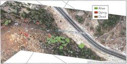
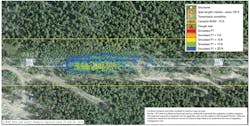
To improve proactive maintenance activities, the challenge for Xcel Energy involved distilling the vast amount of data LiDAR generates to create simple proactive work-management solutions that could be used in the field at a reasonable cost. The first generation of work-management tools came in the form of maps, with vegetation being identified by various colored polygons. The colored areas are generated from the LiDAR data and other high-resolution images. Using these maps, Xcel Energy was able to move some work- planning functions to the office, most importantly critical-work identification like hazard trees, which is work that needs to be done to achieve NERC Clearance 1 distances and other requirements.
It has been the integration of these remote-sensing technologies with software that has helped Xcel Energy mitigate use of the technology from reactive imminent threat and hazard tree mitigation to proactive routine maintenance.
Transmission Wildfire Protection
Better understanding and managing the damaging effects wildfire can have on the electric transmission system provided yet another opportunity to leverage the data already acquired through LiDAR and imagery information to solve problems. As forest health declines, the incidents and severity of wildfires tend to increase.
Xcel Energy formed a fire science team in 2010 to gain a better understanding of the vulnerability of its transmission facilities to wildfire damage and to determine whether there were better ways to manage vegetation in high-risk areas to reduce the potential for damage.
The focus for protection quickly became the structures themselves and, typical of most utilities, the majority of them consisted of wood poles, aluminum lattice and steel towers. Understanding the heat tolerances for these materials became an important first step in the process.
Once heat tolerances were determined, the next step was to understand how heat from both surface and crown fires could be expected to behave near structures, from fuels both on and off the right-of-way. The most important factors were surface fuel load (accumulation of woody debris along the right-of-way floor) and crown closure (density of trees adjacent to the right-of-way).
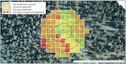
Once threshold triggers were determined for both, Xcel Energy needed a way to quantify these factors quickly and efficiently across thousands of transmission structures. The idea was hatched to have the fire scientist visit approximately 70 randomly selected structures and quantify fuel load and crown closure near the structures. At the same time, the utility challenged GeoDigital with doing the same remotely using the LiDAR and imagery already collected from previous surveys. When the results were compared, it showed a strong correlation between the field-gathered information and algorithmic results. In fact, Xcel Energy had reason to believe the LiDAR-generated results were more accurate.
This work has laid the foundation for statewide wildfire protection work, prioritizing higher risk, higher consequence lines and structures for protective mitigation efforts. Of course, there are implementation challenges, but Xcel Energy has a solid framework from which to commence activities. What Xcel Energy has learned from this journey is being used to initiate similar efforts in other parts of its service territory outside of Colorado.
James S. Downie ([email protected]) is director of vegetation management and ancillary programs for Xcel Energy, a gas and electric utility serving an eight-state region. He is a past president of the Utility Arborist Association and has been involved in utility arboriculture for almost 30 years, including stints with Asplundh Tree Expert Co. and Environmental Consultants Inc. He received a bachelor’s degree in biology with a minor in environmental science from Hartwick College in 1988.
Editor’s note: Learn more about how Xcel Energy’s uses LiDAR on YouTube: http://www.youtube.com/watch?v=MhqaAjWNay8&feature=youtu.be
Sidebar: Sharing Technology Through Collaboration and Coordination
By Teresa Mogenson, Xcel Energy
Xcel Energy’s first foray into light detection and ranging (LiDAR) in the early 2000s was to capture survey information for new line design. The first systematic use of LiDAR was for vegetation management (VM) purposes on existing transmission corridors. It was primarily used to address the hazard tree threat posed by declining forest health in Colorado and to better ensure adequate tree-to-conductor clearances.
In 2009, the utility started to use LiDAR data to review facility ratings, and by 2010, had used LiDAR to survey all lines above 200 kV in areas that had more challenging vegetation conditions. So when the NERC Alert from the North American Electric Reliability Corporation (NERC) came out in late 2010, Xcel Energy had a bit of a jump on developing plans to validate line-rating requirements in some areas. However, lines that had fewer vegetation risks needed to be surveyed (in western Texas, New Mexico and some parts of the plains in various states) as well as all bulk electric system lines 100 kV and above.
This combination of user interest from both vegetation and engineering perspectives created an interesting opportunity to share resources and LiDAR acquisition cost for data, ultimately to create a durable and sustainable asset — a comprehensive, multi-use geospatial information system model.
Effective daily management involves ongoing interaction between VM and transmission engineering (TE) to coordinate LiDAR acquisition, maximizing efficiencies and eliminating potential duplication of efforts. Because vegetation is dynamic, the VM group has a need for refreshed information regarding the state of trees and brush both on and off the right-of-way. When this information is acquired, it is used to develop the next routine maintenance cycle, identify the next crop of hazard trees adjacent to some lines and identify any potential imminent threats caused by changing conditions. This can be a more simplified process than the initial modeling because the original facility information can be recycled, or, if significant changes have been made to facility positioning, new models can be generated. In addition, TE can provide the VM group with the PLS-CADD models created by internal resources, saving VM the cost of having this modeling performed by outside vendors.
The dynamic nature of vegetation may require LiDAR and imagery data acquisition to be performed on a more frequent basis. On more challenging corridors, the frequency is related to the routine maintenance cycle for the lines and is done in between these maintenance cycles. This approach provides some additional assurance maintenance was performed adequately after the last maintenance cycle, and the refreshed data is used to plan and execute the next cycle of work.
As part of the annual planning process, VM typically develops a scope of work for the LiDAR vendor. Before this scope of work is released, VM sends the plan to TE for review. If TE also requires LiDAR for the lines in the VM scope, generally TE takes the lead. This is only possible because VM and TE communicate and understand the LiDAR data requirements for both applications and are able to specify LiDAR flights that will work for both parties.
During the course of the year, the roles can be reversed. For example, because of structure replacement or modifications, TE may have a need to refresh LiDAR in a particular area to revalidate line rating calculations. TE notifies VM of this activity to see if there may be other needs for data acquisition on this same line or a line near the flight path. This level of communication has proven useful in cost-effectively meeting the needs of both organizations.
As requirements and strategies for the frequency of refreshed data evolve for both VM and TE, the plan is to develop an automated scheduling tool that will enable them to optimize the collection of this information, avoiding duplication of effort, unnecessary fuel consumption and wasted expense.
This is the kind of collaboration and partnership that makes Xcel Energy a more efficient electric service provider. The utility recognizes the importance and value that strong relationships between organizations bring to its overall success, and this highlights just one of many that exist throughout Xcel Energy.