Ecological ROW Management with Satellite Analytics
Electric utilities can help to heal the planet by implementing ecological right-of-way (ROW) management practices. Utilities, and particularly their vegetation management programs, can contribute to sustainable ecosystems and avert the causes and effects of climate change.
In today’s world, utilities’ vegetation management programs are shaped by four major drivers — the need to secure reliability and prevent outages; ensure the safety of workers and the public; operate under a constrained budget and follow sustainable practices. Environmental ROW management addresses these drivers by ensuring the sustainability of biotopes; making vegetation more predictable, which leads to fewer outages; reducing the need for dangerous cutting work and risk for wildfires and saving costs in the long run.
The foundations of ecological ROW management include sustaining diverse isotopes in the ROW and limiting the need for interference by targeted UVM measures. Also, it encompasses continuous and extensive, rather than infrequent and intensive, maintenance. As part of this practice, utilities should
avoid exposure of fauna and flora to noise and fine particles and limit the CO2 footprint of vegetation management practices.
Working Toward a Greener Future
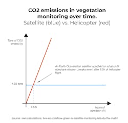
The United Nations has proclaimed the Decade on Ecosystem Restoration for 2021 to 2030. The role of utility vegetation managers in the global effort of restoring ecosystems must be to manage their inventory in a way that prevents, holds and ideally reverses the adverse effects of human interaction with the environment. To achieve this, utilities need to rethink their vegetation management practices and move to ecological ROW management. With their vast networks often lined with vegetation, utilities naturally keep a large inventory of trees and other vegetation capable of carbon sequestration in their ROW. Decentralized by nature, the monitoring of the network and the vegetation around it can become a cause for environmental concern. For example, a helicopter flying at 60 miles per hour emits roughly 500kg (1102lbs) of carbon dioxide for every operation hour, adding up to several tonnes per day. Broken down to a single satellite, the CO2 emissions of a rocket launch to bring a satellite into orbit are surpassed by those of a helicopter after just 8.5 hours of operation.
Other emissions aside from CO2 as well as noise pollution harming animals are further concerns. A satellite, on the other hand, does not interfere with the ecosystem on the ground at all. Satellite analytics solutions can support vegetation managers in multiple steps along the workflow and can be, in fact, the missing piece of the puzzle to implementing more sustainable vegetation management practices.
Case in point: transmission grid operator, Westnetz, together with the governmental German Federal Network Agency, found out in a pilot biotope management pilot project that they could realize relative savings in maintenance costs of up to 35% per year compared to conventional practices in their pilot, which ran more than 15 years. After an initial increase in costs for creating digital maps, project planning etc., the costs per hectare per year fell decisively over the years for the test area. Curated and controlled vegetation in the ROW and high-frequency monitoring using satellites makes the risk management much more predictable, which in turn, means a lower overall risk for tree conductor conflicts.
Taking a Different Approach
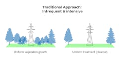
For many years, the go-to approach for securing the ROW has been clear-cutting the corridor in regular, long intervals, meaning infrequent and intensive maintenance. This practice — thankfully rarely applied in this radical form anymore — comes with significant environmental detriments. If the idea is to maintain ecosystems, it is obvious that this strategy misses that goal entirely. When the entire ROW is being cut clear, inevitably the animals’ habitat is lost. Secondly, the practice promotes the growth of fast-growing species as they will be the first to “conquer” the open space left after the cutback. Biodiversity in the corridor will not be achieved.
Progressive vegetation managers have thus been advocating a contrary approach to managing the vegetation in the ROW for the past few years. Instead of infrequent
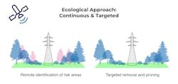
intensive cutbacks, continuous extensive care of the corridor is recommended. Vegetation managers concerned with ecological ROW management act on the
maxime to interfere as little as possible and only as much as necessary in the long term.
To achieve this goal, tree removal is targeted toward fast-growing and invasive species, especially directly within the corridor, where the risk of tree conductor conflict is highest. Through active curation of vegetation in the corridor, it is possible to create a slow-growing system that needs less maintenance over time, which aids in
operating under a constrained budget.
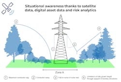
Toward the sides of the corridor, outside of Priority A Zone, vegetation can be allowed to grow taller. Instead of removing everything within a given horizontal distance to the center of the ROW, it is preferable to consider the three-dimensional falling curves of the trees and their potential intersections with the conductor, while also taking into consideration the catenary curves and the line sag and sway.
Creating an Overview
While this new targeted approach to pruning and tree removal is intuitively reasonable, it poses many operational challenges to vegetation managers. Central to targeted measures is information about the situation in the ROW. Vegetation managers need to know what vegetation species grows where as well as its height and potentially declining vegetation health. When vegetation is allowed to maintain a certain height, frequently updated information on the vegetation status is imperative to mitigate risks.
Satellite analytics solutions are the answer to this challenge. While they currently cannot completely substitute the need for on-site inspections, they can provide a near-real-time overview along the entire network, enabling ground workers to only inspect critical segments of the network.
Thanks to multispectral satellite data and artificial intelligence, modern satellite-based solutions can not only detect vegetation location with high accuracy but also provide geo-referenced information on canopy height, vegetation species and its vitality. Combined with accurate GIS data of the assets, vegetation managers have access to an overview of their network.
A complete overview of the ROW and the vegetation encompassing it is useful, but not necessarily actionable directly. This is why satellite-based solutions offer risk models that are based on the abovementioned factors. Based on the risk scoring, the solution creates work orders, which are automatically prioritized, enabling vegetation managers to efficiently allocate resources where needed. The analysis can be repeated several times every year. Thanks to the frequent updates, aerial and ground inspections can be used in a much more efficient manner, only where additional information is necessary, which leads to fewer helicopter flights, less CO2 and noise pollution and less interference with the biosphere.
Doing the Right Thing
The experience from past wildfires and recent large-scale outages indicate that there is a fifth driver that is gaining in relevance at the moment: the perception of the public. With environmental efforts becoming mainstream, it is to be expected that the public eye will also turn toward utilities doing their part in saving our planet and, eventually, ourselves.
Eventually, it is what the public increasingly expects utilities to do. Satellite analytics can help utilities to effectively implement ecological ROW management by providing them at a high frequency with updates on vegetation conditions and with risk-based work orders. They provide the situational awareness necessary to abandon cycle-based practices that are harmful for the ecosystems we live in.
Anthony D. Palizzi ([email protected]) is director of Sales Americas for LiveEO. He served in several executive management positions, leading geospatial, software, technology and consulting firms. He has an extensive track record in delivering high-value solutions to multiple industries. As director of sales at LiveEO it is Palizzi’s responsibility to bring the value from LiveEO’s Earth Observation Analytics and Solutions to utilities in the Americas. Palizzi has a master’s of science/organization development from Regis University and a bachelor’s degree in geology/land use from Metropolitan State University.
About the Author
Anthony D. Palizzi
Anthony D. Palizzi ([email protected]) is director of Sales Americas for LiveEO. He served in several executive management positions, leading geospatial, software, technology and consulting firms. He has an extensive track record in delivering high-value solutions to multiple industries. As director of sales at LiveEO it is Palizzi’s responsibility to bring the value from LiveEO’s Earth Observation Analytics and Solutions to utilities in the Americas. Palizzi has a master’s of science/organization development from Regis University and a bachelor’s degree in geology/land use from Metropolitan State University.


