Enhancing Inspection Methods with Drones
Though once found only in the imagination of sci-fi enthusiasts, drones with remote sensing technologies are now a reality and the industry is growing. According to the Federal Aviation Administration (FAA), more than 850,000 drones are registered, and 325,000 are used commercially. Even with nearly a million drones already in commission, the FAA anticipates a threefold increase in the commercial use of drones by 2023.
Perhaps not surprising, then, is the fact that some utilities are already leveraging the power of drones to assist with vegetation management. But what are drones, and how do they work? What do utilities use them for? Should your utility be using them? If so, where and what for? The following explores reasons why utilities may want to consider integrating drone technology into their traditional inspection program.
What are Drones?
Drones are high-tech, unmanned aircraft piloted from the ground with a remote controller or transmitter. They are also known as UAS (unmanned aircraft systems) and UAV (unmanned aerial vehicles).
The FAA provides a distinction between hobby drones and other UAS: A UAS is an “aircraft” as defined in the FAA’s authorizing statutes and is therefore subject to regulation by the FAA. 49 U.S.C. § 40102(a)(6) defines an “aircraft” as “any contrivance invented, used, or designed to navigate or fly in the air.
An important distinction to be aware of is whether the UAS is being operated for hobby or recreational purposes or for some other purpose … While flying model aircraft for hobby or recreational purposes does not require FAA approval, all model aircraft operators must operate safely and in accordance with the law.
Drones flown for commercial purposes fall under the jurisdiction of FAA regulations — including FAA safety requirements. Utilities must be completely clear in their understanding of this differentiation since non-hobby drones, such as those used by utilities, may only be operated under specific authorization from the FAA.
Advantages of Drones for Utilities
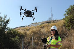
The key benefit of drones is that they can be deployed and respond more rapidly than manned aircraft, says Rachel Miller, an FAA certified private pilot (Part 141), FAA certified remote pilot (Part 107), and project manager and chief supervisor of UAV Operations (Part 137) for The Davey Tree Expert Company.
“With drones, you can avoid hazardous man-hours, save costs and minimize downtime for inspections — without sacrificing data quality, accuracy or safety,” she says.
Drones enable utilities to have access to high-resolution imagery and videos to help them proactively identify, detect, and address environmental, structural, and equipment concerns. Most importantly, drones can help utilities complete asset inspections, prioritize vegetation management schedules, control invasive vegetation and much more.
Here’s a closer look at the five primary advantages of drone technology for utilities:
- Decreases costs: Drones offer flexibility for quick inspections since they can be deployed more rapidly than traditional manned aircraft, making them a more cost-effective solution. They also have the capability to capture and process high-quality data, oftentimes in just a matter of hours.
- Saves time: Drones speed up the time it takes to quickly inspect, scan, survey, map and assess a smaller area. This drastically cuts the time it takes to the verify flight authorizations needed to acquire, process and deliver data. In fact, drones can deliver final data in days as opposed to the weeks it can take with traditional aircraft deployment authorizations.Improves safety: Drones provide a bird’s-eye-view of structures and features, providing a safer alternative for visibility over difficult or hazardous terrain while limiting employee exposure to harsh environments.
- Reduces workload: Automated flight plans and streamlined data processing workflows allow drones to cover more ground, thereby boosting productivity. Drones can help utilities gain efficiencies, too. By flying a versatile aircraft capable of attaching multiple camera sensors to capture data simultaneously, fewer flight hours are required to accomplish the mission safely.
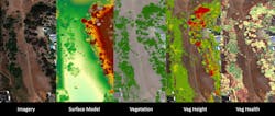
- Maximizes intelligence: Drones gather and deliver professional-grade, high-resolution imagery and videos, as well as valuable multispectral imagery to proactively identify issues and defects that the naked eye cannot detect.
Benefiting from Drone Technology
Utilities are continually on the lookout for ways to reduce costs and complete their work safely and more efficiently, and drones are the newest way to help them to achieve this mission. As a technological innovation, drones can be used to complement traditional methods for routine and emergency inspections.
Drones also can assist utility companies in improving operational productivity by enabling visual line of sight (VLOS) and beyond visual line of sight (BVLOS) operations. This capability allows utilities to receive meaningful data, including images, secure live video streaming and 3D visualization and mapping.
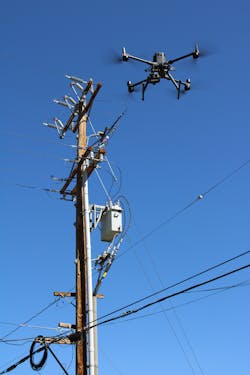
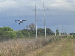
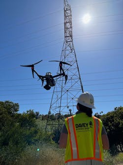
Asset Management/Renewable Energy. Inspecting high-value assets is a critical, yet difficult endeavor. This is due, in part, to the location of these assets, as well as the sheer number of them. Drones enable utilities to inspect and assess towers, equipment and poles for structural concerns such as split-top poles and broken crossarms, cracked insulators, damaged bolts and components, connectors, tie wires and line splices. Here are some other applications.
Drones also offer a much more efficient method of inspecting solar panels for an accurate reading of solar farm efficiency rates, as well as identifying locations of damaged solar cells/panels for repair. Drones have been proven to be a much safer alternative for inspecting on-shore and off-shore wind turbines, too.
Pipelines have an additional use case for this technology. By attaching an optical or laser gas detection sensor to a drone, organizations can identify the location of methane leaks and other harmful gases from a safe distance.
Smaller, portable sized/foldable/fixed sensor drones can be carried in a backpack and equipped with an all-in-one radiometric thermal and RGB color sensor can be useful for getting into tight spaces and around vegetation. They’re also suitable for reaching hard-to-access terrain that might otherwise require inspection crews to hike
off-road and into potentially dangerous areas.
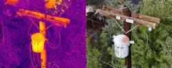
Utilities can use drones that have a larger platform and a longer flight time. They’re useful for carrying heavy, swappable payloads or sensors. Cameras with multiple integrated sensors, including wide-angle, zoom, thermal, and laser-range finders, are capable of capturing closeup and detailed photos. This can help utilities pinpoint a variety of potential issues, as well as hot spots and equipment defects.
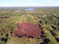
Environmental Consulting. While invasive vegetation control (IVC) can be achieved through various methods, drones are proving to be a safer, more cost-effective method. This is because they can be operated manually or autonomously while flying within a few inches of a target.
Such targeting promotes higher accuracy and greater productivity, as well as limits exposure to vegetation-controlling herbicides.
Drones also can be equipped with high-resolution, multispectral red-edge and near infrared (NIR) sensors, as well as thermal imaging sensors. These sensors can assist in the identification, detection and mitigation of environmental issues, such as aviary nest concerns, habitat observations, wetland invasive species control and pest/disease monitoring.
Drone-led environmental inspections also have coastal applications, such as tracking post-storm sand movement, beach renourishment and stream buffer vegetation growth.
Line Clearance/Storm Response. Drones are very useful for live-stream, real-time pre- and post-storm inspections, as well as monitoring easement clearances to mitigate risks. Drones equipped with high-resolution video can capture work completed for auditing purposes.
Because drones offer such a unique vantage point, utilities can better anticipate equipment needs, especially when first responders and utility line clearance crews are dispatched to potentially hazardous environments or areas with difficult terrain.
Drone operators may be granted special waivers for BVLOS, which allows for expedited damage assessments and more efficient routing to geospatial locations.
Construction Monitoring. For utilities, routine surveying is fundamental for tracing development, safety inspections, and real-time quality monitoring. Drones enable an aerial view of an entire project, which could help reveal concerns that might not be possible with ground-level inspections.
Vegetation Management. Drones can quickly and easily fly down a corridor or right-of-way, providing both VLOS and BVLOS capabilities. The data collected can then assist utilities in prioritizing vegetation management schedules. Captured drone data can assist with monitoring vegetation encroachment, identifying and monitoring pests and diseases and assessing the health of trees to proactively identify possible fall-in risk.
In addition, drone service providers with an FAA (Part 137) Agricultural Aircraft Operator Certificate for commercial pesticide spraying/seeding applications, have a significant advantage over manned aircraft since they can spray invasive vegetation with minimal manpower and reduced equipment needs. They can get much closer through spot spraying, thereby lessening the exposure of the crew to herbicides and a more precise application with less likelihood of windswept herbicide. Additionally, drones cause less ground disturbance than traditional applications by heavy machinery.
How to Integrate Drones
While drone technology is incredible, the technology itself is only the beginning, Miller says. “It’s important to keep in mind that drones aren’t just a mini version of traditional aircraft,” she says. “They’re operated under their own set of rigorous and exacting FAA rules and regulations.” This means that utilities must look beyond the drone’s capabilities and consider factors such as developing and maintaining an advanced training program and detailed safety procedures to mitigate any possible risks during flight.
Drone pilots must be trained to be well-prepared for emergency procedures, capable of risk assessments and equipped to handle such things as field inspection tests. For safety, drone pilots must be well-versed in operational flight planning, especially as it relates to weather and airspace, fleet management, maintenance and flight logs. Any commercial drone flight operation must include the required amount of asset and liability insurance as well.
“FAA regulations can be complicated,” Miller says. “Just because someone can get a remote pilot license, doesn’t mean they’re qualified to conduct the kind of work utilities require.”
For example, Miller, who holds not only an FAA Private Pilot (Part 141) and Remote Pilot (Part 107) license but is also listed as the FAA-approved Chief Supervisor on Davey’s (Part 137) Agricultural Aircraft Operator Certificate, recommends that utilities seek out the services of those who hold similar certifications.
“These certifications demonstrate a level of experience that’s important when it comes to safely operating a drone,” Miller says. “The fact is, drones can easily run into issues during flight, especially when operated by an inexperienced pilot. That’s why safety should be of the utmost importance.”
Safety, in fact, is the biggest reason the FAA (Part 137) Agricultural Aircraft Operator Certificate is particularly difficult to obtain. Applicants undergo a rigorous, five-phase certification process that requires the demonstration of a certain level of knowledge and skill regarding agricultural aircraft operations.
So, whether a utility decides to launch its own program or employ the services of an outside firm, it’s important to remember that technology, safety, training and certifications are all crucial factors to consider.
Additionally, strict FAA regulations, waivers, and rules govern the “who, what, when, and where” drones can fly. There are state and local privacy laws to be aware of regarding airspace, too. And then there’s the actual equipment.
“There’s a big difference in the quality of imagery between an off-the-shelf photography drone and more advanced sensors,” Miller says. “There’s also the matter of cost. Drone technology is typically not a budget-friendly investment for the kind of work that utilities require. That alone might be reason enough to consider bringing in a consulting services professional.”
Drones vs. Traditional Inspections
When it comes to whether drones or traditional inspection are the better choice, the answer is both. One method is not superior to another. Comparing drone inspections to traditional inspection methods is like comparing one brand of cola or snack chip to another. They each have their pros and cons.
Deb Sheeler, GIS/IT Support Services production manager at Davey explains, “We have a motto around here: ‘Right tree, right place.’ The same can be said of drones. They’re the platform to help safely apply and capture different types of data remotely. Having a versatile fleet and understanding our utility clients’ needs is key to providing the ‘right’ solution. And the ‘right’ solution always involves the input and expertise of a qualified professional.”
Drones — or any technology, for that matter — cannot replace what experienced professionals bring to the right solution. From visual/IR/thermal cameras to leak detection sensors to spray/seeding applications, certified drone pilots work directly with skilled remote sensing professionals to process and analyze data. That, coupled with field inspectors who possess industry knowledge, can help further identify specific concerns or issues, such as pests or diseases, equipment failures and issues involving North American Electric Reliability Corporation (NERC) compliance.
The fact is utilities need data. So, when data isn’t readily, easily or cost-effectively available by traditional means, then integrated drone and remote sensing solutions might make the most sense. The good news is that remote sensing technologies have come a long way, making drone services a smart, value-added supplement to conventional inspection methods — and typically at a much lower cost than traditional aircraft.
“Keep in mind that when integrating drone technology, there’s much more to making it a success than the technology itself,” Miller says. “Seek out a consultant that’s well-credentialed and trained in the technology, has deep industry knowledge, and is experienced in vegetation/asset management and environmental consulting. Then crunch the numbers. If a traditional method yields a better value, then go the traditional route. Otherwise, go with drone services, which can offer both time and cost savings, as well as deliver more accurate data, more quickly.”
Jack McCabe ([email protected]) is the vice president and general manager of Utility Vegetation Management Solutions for the Davey Resource Group where he leads the utility vegetation management consulting group to ensure it delivers solutions that result in client success and creates opportunities for employee advancement. McCabe has more than 25 years of experience in the industry, building leadership, supporting employees and helping clients make their programs safer, more efficient and more sustainable. McCabe earned his bachelor’s degree in environmental studies from the University of California at Santa Cruz and has held leadership roles with several industry associations.
Drone Inspections: What to Ask a Potential Provider
The following are some questions to ask for utilities looking to hire a consultant or drone service provider:
- Does the consultant hold the necessary FAA certifications, waivers or exemptions required to complete the work, such as FAA (Part 137) Agricultural Aircraft Operator Certificate or required additional exemptions/waivers for special operations such as the operation of drone 55 lbs-plus, flight over people, flying at night or BVLOS?
- Does the consultant have a safety/maintenance program outlining operational procedures and training requirements?
- Does the consultant have the necessary equipment, such as advanced aircraft and/or high-end sensors capable of capturing the required data?
- Does the consultant have licensed drone pilots with industry-specific training and field experience for projects, such as utility asset inspections or herbicide spraying?
- Does the consultant have pilots with additional certifications and/or a qualified team of professionals that can analyze and process accurate data, such as temperature readings for hot spot detection and vegetation health assessments?
- Can the consultant capture and provide deliverables that meet your needs? Examples include high-resolution and detailed digital photos or videos, multispectral imagery and analysis, 3D visualization and mapping, LiDAR acquisition and processing, secure live video streaming, etc.
- Can the consultant deliver the final data products in a specified format that can be directly import into your existing data management software or can the consultant provide secure data management software?
- Is the consultant insured and able to meet the necessary liability coverage requirements?
Talking Drones: Understanding the Lingo
There’s a vocabulary accompanying drones that can sound a bit like another language, especially to those new to the world of drones. Here are some basics terms and meanings.
- 3D visualization and mapping: the ability to capture three-dimensional data and detail using a camera sensor
- BLVOS: beyond visual line of sight; the ability to fly a drone beyond the pilot’s visual range
- Drone: high-tech unmanned aircraft piloted from the ground
- FAA: Federal Aviation Administration; government agency that regulates aircraft, including drones
- Visual sensor: a digital color sensor that detects the well-known color system values of red, green and blue
- Multispectral sensor: a sensor that collects visible wavelengths and wavelengths that fall outside the visible spectrum, including near-infrared radiation (NIR) and short-wave infrared radiation (SWI)
- UAS: unmanned aircraft systems, which include the UAV (or drone) and the person on the ground controlling the flight, as well as the system in place that connects them
- UAV: unmanned aerial vehicles; often used interchangeably with drone
- VLOS: visual line of sight; a flight in which the pilot maintains continual visual contact with the drone
About the Author
Jack McCabe
Jack McCabe ([email protected]) is the vice president and general manager of Utility Vegetation Management Solutions for the Davey Resource Group where he leads the utility vegetation management consulting group to ensure it delivers solutions that result in client success and creates opportunities for employee advancement. McCabe has more than 25 years of experience in the industry, building leadership, supporting employees and helping clients make their programs safer, more efficient and more sustainable. McCabe earned his bachelor’s degree in environmental studies from the University of California at Santa Cruz and has held leadership roles with several industry associations.