Leveraging LiDAR in Vegetation Management
Electric utilities have installed Light Detection and Ranging (LiDAR) units on helicopters, aerial drones or on the ground. While similar to radar, which uses radio waves to detect objects and their distances, LiDAR’s measuring capabilities are augmented by the ability to create three-dimensional models, high-resolution images and tap other key analytic options.
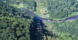
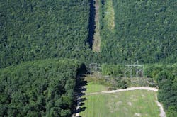
FirstEnergy first began using LiDAR, a remote sensing application using a laser’s infrared light to measure distances, in 2010 to identify potential transmission line clearance concerns. LiDAR identifies clearance distances between conductors and other objects in the right of way (ROW), providing vital verification in hard-to-reach locations.
Making a Case
Given FirstEnergy’s ongoing familiarity with LiDAR, along with advancements in the data analytics aspects of the technology, the company’s Vegetation Management group sought to explore the feasibility of integrating LiDAR into its existing maintenance programs. In particular, the group looked to use LiDAR to validate compliance with North American Electric Reliability Corporation (NERC) standards by confirming the lack of vegetation encroachments along the ROW.
“With nearly 300,000 total miles of power lines that help us serve more than six million customers in five states, trimming trees and controlling vegetation is vitally important for FirstEnergy,” said Rebecca Spach, director, Vegetation Management. “Our transmission lines alone stretch across more than 24,000 miles of diverse terrain. Maintaining required clearances in the farmlands of northern Ohio, the dense woodlands of Pennsylvania, the rugged mountains of West Virginia and Maryland, and the beaches and wetlands of New Jersey results in vegetation management challenges unique to each topographical area.“
To help ensure service reliability, FirstEnergy implements a layered vegetation management approach using its professionals, practices and protocols to not only meet existing standards, but also to constantly look for ways to advance safety, efficiency and reliability. The program includes planned cyclical vegetation management programs and yearly inspections from crewed aerial flights. Between planned maintenance cycles, it also conducts additional off-cycle foot patrols.
In 2016, FirstEnergy initiated a one-year pilot project to determine if LiDAR could help the company meet the high transmission vegetation management reliability standards already established. The goal was to determine if the vegetation management clearances could be verified and maintained through LiDAR with the same degree of accuracy, while potentially reducing the number of flights, truck rolls and foot patrols previously used.
Enhanced safety and efficiency also were potential LiDAR benefits. Foot patrols—an integral part of the vegetation management inspections—can be time consuming and sometimes dangerous due to potential hazards from the natural environment. Manned aerial surveillance can also come with risks—from weather, terrain, and sometimes unpredictable flight conditions.
If the year was a success, LiDAR could make the vegetation management efforts more proactive, providing reliable data that could help refine, reduce or even alleviate portions of the planned on- and off-cycle manual inspections.
Year One Shows Positive Results
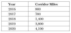
FirstEnergy began its one-year trial using LiDAR to assess about 800 miles of 69 kV, 138 kV, and 345 kV transmission ROW in Ohio.
“Our plan called for LiDAR vendor GeoDigital to train representatives of our vegetation management team how to best use the system, and how it compared with the measuring instruments that we had traditionally used,” Spach says. “While it took some time to get comfortable with the new technology, it became obvious that LiDAR could have an important place in FirstEnergy’s overall vegetation management program.”
As the project moved forward, the Vegetation Management group collaborated and shared the LiDAR information with other FirstEnergy business units – a practice that would bring new and promising benefits.
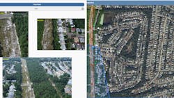
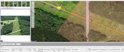
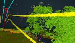
A Data Trifecta
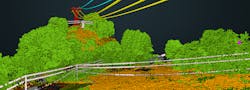
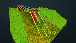
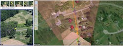
Once the LiDAR missions were flown, the data was refined and presented in three ways: the aerial imagery was corrected to remove any distortions; the vegetation management clearance information was converted into polygons, or easy-to-understand visual icons; and a three-dimensional cloud model that could
be manipulated and explored from any location within the project scope. In essence, a highly accurate digital representation of the transmission line ROW was created.
Potential benefits became clearer as the team realized the precision of the data. For example, a forester on a typical foot patrol might hike more than 50 miles to identify minimal vegetation work needed along a ROW during an off-cycle year. By proactively using LiDAR data, time can be saved by directing someone to areas that need the most attention.
Based on the results it was seeing, FirstEnergy’s Vegetation Management Group began expanding the use of LiDAR, adding hundreds of corridor miles each year.
As part of this process, the utility recruited and trained a task force of “super user” company foresters from across the FirstEnergy system to support communication
efforts and manage the day-to-day tasks needed to move the LiDAR project forward.
“To compliment the work being done on the transmission system, in 2020 our group began another pilot program, this time on distribution circuits,” Spach says. “We identified roughly 150-line miles of 25 kV circuits with the goal of understanding potential LiDAR benefits for distribution vegetation management programs. The team is currently evaluating the data that was obtained as part of the pilot.”
By the end of 2021, FirstEnergy will have collected LiDAR imagery and data for nearly 12,000 total corridor miles, including the majority of 69 kV, 115 kV, 138 kV, 230 kV, 345 kV and 500 kV circuitry. The effort was made possible by the collaborative efforts of many company foresters, vendors and several other business units.
Discovering Benefits
To enhance reliability, LiDAR modeling tools allowed the team to explore potential scenarios and physical factors—such as the effect of load and temperature or the potential for wind to sway conductors or the vegetation around them—to eliminate the guesswork from clearance measurement. For the first time, the team was able to understand where conductors would be at maximum operating temperatures to verify appropriate clearances in the hottest months of the year.
.
The LiDAR data also helps set maintenance priorities that support reliability. For example, if the data indicates where vegetation in the ROW may not meet the requirements at the time of planned cyclical maintenance, more targeted work can be implemented. Reliability can be enhanced by identifying off-corridor trees—or those that are outside the established ROW—that could affect the wires if they fall.
LiDAR also can enhance overall safety by reducing the number of field visits required. If foresters need to physically inspect a transmission line, they can take a virtual look at the condition of the ROW before heading out. Knowing in advance about a blind spot or inaccessible area through digital imagery can help reduce exposure to hazardous conditions. Manned aerial surveillance can also gain important safety protections through LiDAR by locating wire crossings on or near ROW.
Using LiDAR also has the potential for workforce management benefits by reducing the need for mid-cycle foot patrols by 50%. The FirstEnergy Vegetation Management Group also now flies 50% fewer manned aerial surveillance missions on 230 kV rights-of-way. This saves time, avoids unnecessary equipment usage
and frees resources for other priorities during the spring and summer, which are the busiest seasons for utility vegetation management at FirstEnergy.
Collaborative Culture Shift
FirstEnergy’s culture of supporting new technology, system improvements and making safety a top priority helped with the LiDAR implementation process. In one-on-one meetings and small group discussions among several business units, the team talked about the benefits and use cases of the LiDAR technology and how it could be integrated throughout the company. The LiDAR project also gained and maintains support from FirstEnergy leadership, who helped move the project forward.
Along with the Vegetation Management Group committing resources for transmission work, the Transmission Engineering Department also stepped in to assist with a more efficient way to provide the base LiDAR data needed to process vegetation clearance information. These additional efficiencies helped the project expand.
Broader Impacts of the LiDAR Data
FirstEnergy’s Transmission Engineering Design, Transmission Maintenance and Transmission Planning and Protection Group groups use LiDAR data to facilitate engineering, maintenance and protection.
“LiDAR has benefited several transmission departments and has changed how we identify potential clearance concerns,” says Bryan Hunsche, supervisor of transmission engineering design. “FirstEnergy collects LiDAR data that is utilized by Vegetation Management, Transmission Engineering Design, and Transmission Maintenance. We utilize the data to assist in site evaluations and enhancements to project scopes. Having LiDAR data readily available has accelerated the engineering process and reduced the amount of survey work needed for new projects.”
Andy Liedel, transmission maintenance program manager, added that FirstEnergy uses LiDAR to supplement inspection programs, identify ROW issues, assist with asset inventory and tracking and help with other maintenance activities.
“Access to the LiDAR imagery has saved us from making trips to the field, which enhances safety by reducing potential exposure,” Liedel says. “Sharing this information across departmental lines has increased our efficiency and helps us maintain the integrity of our transmission system.”
The Transmission Planning and Protection Group has also used the LiDAR data for a detailed tower by tower model for impedance calculations. This allows validation of data to ensure power flow studies are accurate. In addition, this data can be used with GPS to calculate what transmission lines are close enough to each other to impart a mutual coupling, which is the influence of the magnetic fields of two or more parallel circuits and the power flowing through them. Ultimately, the LiDAR information is used to determine the proper relay settings to help protect the transmission lines.
Future Plans
Going forward, FirstEnergy’s plans to update its LiDAR software, expand its use of the artificial intelligence features and continue to use LiDAR to support distribution vegetation management programs. The spirit of LiDAR collaboration will continue throughout the company as well.
Evelyn Mack is a supervisor for the FirstEnergy Distribution Vegetation Program Management program. She earned her bachelor’s degree in biology and minor in psychology. An ISA Certified Arborist and ISA Utility Specialist, she has her ISA Tree Risk Assessment qualification and OH Pesticide License with more than 18 years of experience in the utility vegetation management industry.
Luke Henne is an advanced transmission forestry specialist for FirstEnergy. He earned his associate’s degree in forest technology and a bachelor’s degree in mapping sciences. An ISA Certified Arborist and ISA Utility Specialist, he is PA Pesticide Certified with more than 10 years of experience in field and desktop
utility right of way management.
For More Information:
GeoDigital | https://geodigital.com/
Three Tips for Transformation
- It takes a team. From the Vegetation Management Group to other utility business units that will need to support the effort, communication is vital. FirstEnergy’s LiDAR Team created a cross-functional team to hold quarterly meetings and share data and resources between these groups
- Discuss the vegetation management program goals and ideas with industry peers and vendors. Create a roadmap before proceeding with any LiDAR project.
- Be prepared to ask the hard questions. Understanding the technology will help identify where it will be most useful.
About the Author
Evelyn Mack
Evelyn Mack is a supervisor for the FirstEnergy Distribution Vegetation Program Management program. She earned her bachelor’s degree in biology and minor in psychology. An ISA Certified Arborist and ISA Utility Specialist, she has her ISA Tree Risk Assessment qualification and OH Pesticide License with more than 18 years of experience in the utility vegetation management industry.
Luke Henne
Luke Henne is an advanced transmission forestry specialist for FirstEnergy. He earned his associate’s degree in forest technology and a bachelor’s degree in mapping sciences. An ISA Certified Arborist and ISA Utility Specialist, he is PA Pesticide Certified with more than 10 years of experience in field and desktop utility right of way management.