AI Improves Resilience of Vegetation Management
Customers depend on affordable, uninterrupted electrical service. Shareholders demand better financial performance. Government agencies insist upon strict adherence to regulations. How do we balance these requirements in a world that has about 6 million circuit kilometers (Ckm) of high-voltage transmission lines and 60 million Ckm of distribution lines, often in close proximity to more than 300,000 vegetation species? How do we conduct inspections, monitor real-time hazards and proactively prioritize scarce vegetation management resources when lines are located in environments that range from polar tundra to arid deserts, tropical forests and temperate urban centers? It’s a challenge that transmission and distribution companies face every day. And with escalating climate change, mitigating the risks associated with vegetation has become increasingly paramount.
Utilities make decisions about where to focus their vegetation management efforts based on the best information available to them. Unfortunately, due to the size of their service territory, variations in vegetation species and dynamic weather patterns, a cost-effective mechanism to obtain real-world vegetation conditions has been elusive. In the absence of this knowledge, utilities have developed approaches that rely on past experience and rules of thumb, such as average growth rates, leading to techniques such as fixed cycle management.
In the past few years, utilities have been experimenting with new technologies that hold the promise of providing rapid and accurate vegetation insight. These include image capture and light detection and ranging (LiDAR) scans collected through drones and manned aircraft. But even new technologies present their limitations. Aerial studies are prohibitively expensive and time consuming to conduct over a broad territory, leading to targeted scans on specific areas of known risk. In addition, extracting value from all this data requires it to be supplemented with analytics. While this may seem simple, the process of collecting, cleaning and analyzing massive data sets in many different formats is tremendously complex.
Focus Scarce Resources on Areas with Most Impact
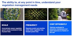
Understanding the attributes of vegetation with accuracy can drive informed decisions. However, to have a material impact across the entire vegetation workflow, several factors need to be considered: scale, frequency and cost efficiency. Utility vegetation managers must make decisions that impact huge territories. For this, they need to incorporate into their decision processes multiple categories of information that have a high spatial and temporal granularity.
Utilities are continuously under pressure to achieve better outcomes at a lower cost. Vegetation management budgets
are almost always insufficient to address needs across the entire service territory. To maximize the value of their vegetation management program, utilities need to focus on areas that present the most opportunity to mitigate risk.
Without knowledge of risk across the service territory, utilities are forced to rely on measures such as fixed cycles. What if we could push a circuit scheduled for cycle treatment back a year with minimal impact to risk? What if we could use that saved resource to treat an area sooner than its prescribed cycle if it presents an escalated risk level? The only way to achieve this level of optimization is to have vegetation insights at scale, across the entire service territory, and the means to aggregate and handle these insights.
Vegetation grows. Seeds and spores are transported by nature, altering species composition in a given area. Weather, soil conditions, human influences, pruning, herbicide applications and insect infestations can impact the vegetation state, growth rate and health. Vegetation changes based on weather, human influences and other factors. It is not uncommon for gaps between manual inspections to be long enough for a sapling to grow into a formidable tree and cause an outage, or for a previously barren shoreline to become an inhabited wetland. The value of insight gathered at a single point in time diminishes quickly, limiting the ability to make informed decisions in an ongoing vegetation management program. The ability to obtain insight on a frequent basis is necessary to facilitate reliable long-term decision making and opens up additional use cases such as including post pruning or herbicide audits and smart, data-driven contracting.
Scale and frequency are only relevant if they can be executed cost efficiently. LiDAR may provide tremendous accuracy; however, the associated costs restrict its broad use across the service territory. If a LiDAR scan is performed at scale, it is often done infrequently, perhaps every three to 10 years, limiting its value after the initial use and the use cases it can serve. A feasible remote sensing solution must combine scale, frequency and cost efficiency to benefit an effective vegetation management program.
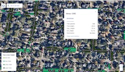
Fig 1: Reduce vegetation infringement with power lines at scale by using insights from geospatial data and analytics to more frequently assess the state of the vegetation and its proximity to your assets.
Integrate and Analyze Data to Produce Actionable Insights
IBM® has developed a vegetation management solution that enables utilities to digitally transform their vegetation management program. Leveraging high-resolution satellite and aerial imagery, artificial intelligence (AI) and geospatial analysis, IBM can rapidly and accurately identify and assess vegetation with frequency — across a company’s entire distribution and transmission territory — in a cost-effective way that wasn’t even imaginable a few years ago.
IBM has been working with transmission and distribution utilities across the globe, subject to vastly different climates and vegetation species, to prove the capability of this approach. Its projects have been rooted in building trust of the derived insight through deep engagement with forestry departments, including field validations with arborists and planners to compare the digital results to those found in the real world.
To get started, a utility need only provide the location of corridors or conductor locations with corridor specifications, which typically come from a utility’s GIS. The IBM Vegetation Management solution ingests this information and layers it with other sources of data, including high-resolution aerial and satellite multi-spectral imagery (as granular as 0.6m resolution or less). Leveraging IBM PAIRS, IBM’s flagship geospatial-temporal analytic platform, each corridor is analyzed across the entire service territory. This approach provides the flexibility to incorporate additional layers of geospatial data, including LiDAR data, if available.
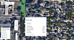
For each corridor, the location and state of vegetation is determined, including distance to conductor, average tree height and maximum tree height. Advanced attributes, including tree species, can be derived today with sufficient ground truth data. IBM is currently working with clients on tree health models and growth rate estimations, providing further insight into their environment.
Fig 2: Using machine learning and AI techniques the system is trained to differentiate tree cover down to the street/area level, overlay the utilities' primary lines to look at the proximity of trees to the utility assets, and analyze other attributes like tree height and tree species.
From Vegetation Insights to Actionable Work
For insights to deliver on the promise of business value, they need to be turned into actionable work (Fig 2). If a utility cannot make a better decision based on the derived insight, nothing has truly been accomplished. Scrolling through thousands of Ckm of conductor looking for areas at risk is simply not feasible. Tooling is required to inject this intelligence into the vegetation management workflows.
The IBM Vegetation Management solution embeds methods that have been successfully used in the field of asset performance management: aggregating and leveraging multiple disparate data sets and calculating meaningful scores and indicators. This helps the vegetation manager more easily identify critical corridors, understand actions to be undertaken and rank them according their urgency, criticality or related risk. The proposed toolset thus may help vegetation managers in their move from purely time-based practices to hybrid condition- and risk-based vegetation management practices (Fig 3).
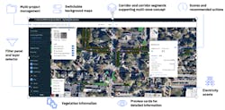
Fig 3: The decision platform provides full visibility on the vegetation situation to enable users to explore, examine and quickly take action.
Once the state of vegetation is understood, it is possible to determine a vegetation score that indicates the relative risk for a given portion of a circuit. That risk, however, does not represent the relative overall risk to operations. A circuit with significant infringement that has few service delivery points may represent less risk than a circuit with modest infringement but thousands of service delivery points that include critical locations such as hospitals. Incorporating additional information, such as the connectivity model, outage history, customers and trimming history, allows the solution to determine an overall risk that can be used to make actionable decisions.
Ensure that corridors and assets remain free of encroachment by pinpointing sectors for strategic maintenance, rather than deploying tree-trimming crews based on calendar schedules. Manage a smarter competitive bidding and contracting process appropriately assigning manhours and budget. Improve the auditing process by performing audit work remotely to validate that the vegetation actions have been effectively completed. Assign more expensive resources to areas of concern that may require a more detailed manual audit.
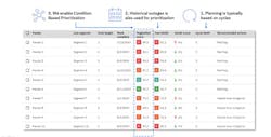
The IBM Vegetation Management solution provides a geographical overview of the entire service territory, allowing users to drill down into smaller zones and into pre-defined corridors and corridor segments. It narrows the focus into areas that require immediate handling or attention. KPIs, as well as recommended actions with priority scores, help identify risks so companies can make informed decisions that reduce the risk of line interference and improve operational performance.
Alternative list views allow sorting by priorities enabling users to make decisions on where to focus their scarce resources (Fig 4).
Fig 4 : Enable condition-based vegetation management.
They can group areas to be handled in a more efficient way, and easily define and assign vegetation work activities at a more granular and specific level.
The solution is remarkably scalable and surprisingly affordable. It can be customized to each organization’s specific requirements. IBM believes this solution signifies a new era for transmission and distribution companies that are under such tremendous pressure to cost effectively improve performance and reliability while also respecting our delicate environment.
Consider the benefits to be achieved through the implementation of geospatial-temporal analytics and AI. The adoption of these technologies will enable you to manage vegetation more cost-effectively through a scalable, flexible support system – a system that generates greater results by empowering your team with knowledge.
