Vegetation Management: Artificial Intelligence to Preempt Forest Fires
Life for millions of energy consumers in the United States came to a grinding halt several times in the last few years due to large-scale power blackouts caused by forest fires. Transmission and distribution lines and critical infrastructure belonging to utilities are spread over thousands of miles, often, through poorly accessible wilderness. Overgrown vegetation and dead trees can touch and fall on power lines causing break downs and short circuits. They can also cause forest fires, and when they go unchecked, flare up into major ones.
The vegetation across thousands of miles requires constant monitoring, pruning, and maintenance to ensure the right-of-way is constantly maintained. Even after utilities spend millions on vegetation management, they often face challenges in protecting their transmission and distribution lines, transmission towers, transformers and substations. Is it time to adopt new methods of vegetation management, this point of view try to explore solutions?
Currently, vegetation management is done through two ways: the traditional manual approach and the automated method, which uses advanced digital technologies.
The Traditional Approach to Vegetation Management is Unsustainable
In the manual approach, the data collection, data processing, risk mitigation plan and implementation is schedule-based. The crew on the ground monitor demarcated areas. Arborists manually inspect the right-of-way, assess the risk from vegetation and decide whether it needs to be pruned or removed. Sometimes, the inspection and the maintenance crew differ, and there is a time lag between the activities of the two. This manual activity of monitoring the power lines is time-consuming, incurs significant overheads and delivers mixed results. For instance, the inspection crew may not accurately assess a threat to the power line, or a tree may bend and fall over soon after an inspection. Since the area that needs to be monitored is vast, inspecting the service territory can be four- to six-year cycles. Decisions regarding cutting or pruning are taken based on experience and hence is limited by fieldworker capacity.
Regulations Supporting the Vegetation Management Efforts of Utilities
According to the California Public Utilities Commission (CPUC), just three investor-owned utilities (IOUs) in California spend about US$1 billion annually on vegetation management, and yet the process remains largely manual.
To augment the effort of utilities, the CPUC, along with the California Department of Forestry and Fire Protection, and the U.S. Forest Service have set vegetation clearance requirements for the distribution network of utilities. Also, CPUC has developed fire-threat maps that take into account the historical data of forest fires and tree mortality. Though numerous states have policies similar to those in California, compliance with stringent clearance standards can only be a starting point for rights-of-way vegetation management programs. With costs of vegetation management rising year-on-year, followed by a shortage of manpower, increasing concerns regarding safety and the need to prevent rather than douse raging wildfires, utilities are turning to smarter technology.
Exploring Newer Solutions to Vegetation Management
An automated approach to vegetation management uses advanced digital technologies to capture and process data and put together a risk mitigation plan. Many utilities leverage aerial surveillance--helicopters and drones--to simplify and hasten the monitoring of their geographies. These vehicles spend weeks gliding along transmission and distribution lines and taking images of the infrastructure for analysis.
Many utilities adopt LiDAR to capture visuals of the power lines and surrounding vegetation. These images are captured by cameras from an altitude, which may range from anywhere between 2,000 and 10,000 ft. These visuals are then analyzed to locate areas that need attention. For instance, to pinpoint where the right-of-way is being obstructed, locate dead or dying trees and other potential hazards to expensive infrastructure.
While LiDAR has been effective for visual capture, analysis of visuals of a 1000 square miles is known to take as much as two months. This means that by the time the analysis is tabled, the data could be outdated by a certain percentage. This is problematic as costs associated with LiDAR image capture are high and the visual mapping cannot be repeated on a quarterly, or even half-yearly basis. This takes the utility back to guesstimating and working with outdated data even after significant investment.
From Feet on the Ground to Data Analytics and AI
Many concur that the way to access accurate and actionable insights for vegetation management is to adopt a data-first approach. A team of utility professionals, data scientists and artificial intelligence experts at Infosys have developed an analytics solution that is fast, insightful and scalable. The solution uses data science, machine learning and computer vision to analyze images.
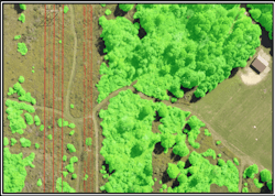
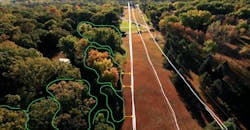
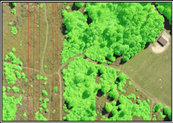
High-resolution orthogonal and oblique images are processed by algorithms, which use photogrammetry to stitch the LiDAR images into a 3D point cloud. Subsequently, deep learning algorithms segment regions in this point cloud denoting trees, wires, towers, transformers, buildings and other infrastructure. The algorithms also generate heat maps across the utility network area, these evaluate the topography, identify areas of vegetation, point out high-risk areas based on the canopy height and proximity of the foliage to the power lines and visually depict the probability quotient of fire hazard and tree fall.
The Infosys vegetation management solution for utilities ingests data from other internal data streams such as from the Geographic Information System (GIS), outage management system and asset management system. Simultaneously, it aggregates data from external sources such as weather forecasts and historical data. The solution blends structured (digitized information) and unstructured (imagery of topographical features, fire-threat maps, and hand-written notes of vegetation management crew) data to create a comprehensive visualization on a dashboard that is current, insightful and actionable. Now the entire time cycle of data capture, processing and risk mitigation plan implementation can be reduced from four to six years to four to six weeks.
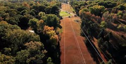
Vegetation around Electric Lines
Vegetation Segmentation and Distance Computation
Deep learning-based Vegetation and Transmission lines identification
Deep learning-based Vegetation & Transmission lines identification
From all-terrain surveillance to risk prioritization
A holistic network perspective provides utilities with timely and informed insights to undertake proactive vegetation management. Further, it allows the utility to prioritize attention to high-risk areas vis-à-vis low-risk regions based on vegetation growth, density and ambient conditions.
The benefits of embracing digitalization to manage vegetation across thousands of miles are tremendous. An automated approach that incorporates advanced data analytics and computer vision can help modern utilities keep the lights on for their customer, uninterrupted and protect expensive infrastructure.
