How to Leverage GIS Data

Web-based geographic information systems are powerful tools, offering vital information for asset management and new capital projects. Today, utilities can access these data-rich resources for specific and evolving needs. Utilities of all sizes can benefit from purchasing rapid turnaround mapping solutions that provide exactly the data interpretation and analysis they need, for exactly the amount of time they need it.
Many consultants now build and host geographic information system (GIS) applications in a secure cloud environment for users such as utilities and municipalities. These agencies and organizations can access the geospatial and technology expertise they need to manage data and dashboards without the burden of system ownership, which saves time and money and keeps staff focused on operations. These web-based solutions can aid in documenting inspections, tracking maintenance schedules, managing outages and emergency response activities, and overseeing improvement and expansion projects.
BYOD: Bring Your Own Data
Utilities own and manage a broad array of horizontal and vertical assets that require the documentation and tracking of large amounts of data, including asset type, location, size and age as well as important details about maintenance schedules and life-cycle status. A bring-your-own-data model enables utilities to upload or integrate their data into a GIS platform that is ready to go.
Within a few minutes, data can be loaded, visualized, analyzed and interpreted all inside a web browser. Behind the scenes, data can be encrypted, secured and backed up by the hosting cloud infrastructure. With web-based GIS, personnel will not lose time installing software, configuring licenses or waiting for the service desk to fulfill requests. In this way, utilities can leverage historical and unique data sets to gain context around these disparate variables.
Utilities can harness data in real time from today’s vast ecosystem of mobile devices, interactive websites and open data systems with conversion tools that quickly and efficiently pull information into the application. While just a few years ago this step might have required a significant investment of time to digitize or convert data, the process is much more streamlined today — automating data input from sources and formats such as computer-aided designs, imagery, as-built drawings and sensors.
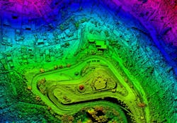
Modern GIS software enables utilities to manage many aspects of their assets in a contextual, visual and map-based database. Instead of the static columns and rows associated with a traditional spreadsheet, information can be tied to a photo or visual image that links to maps, charts, statistics, associated media and reports.
Information can range from large, multilayered data sets for enterprise asset management to project-specific data — for example, creating an inventory of substations to review best practices for stormwater management or planning for a distribution line extension to support new development.
One-Click Custom Reporting
A key feature of web-based GIS infrastructure is the ability to pull on-demand status reports. Single-click report generation can enable users to download formatted reports in seconds to Excel or a PDF. These reports can aggregate statistics across entire data sets or present preselected records. Dashboards can be shared with stakeholders in the office or the field.

For large-scale capital projects, like planning, designing and installing transmission and distribution lines, there are often many moving parts and a robust level of coordination. Having a centralized tool with standardized processes for each project team to contribute to and work from helps create a clear picture of project progress and allows issues to be elevated efficiently and in a timely manner. Further, this allows the utility provider to see everything in one place, like data from contractors, consultants, and those representing the end-user, eliminating the need for individual reports from each stakeholder. Consistent and seamless data results in appropriate resource allocation, focused outreach efforts, and informed decision making..
More Than A Map
Web-based GIS solutions serve many functions for utilities, from scheduling maintenance and facilitating field inspections to setting up automated construction status reports. The platform enables the management of multiple forms of media, including photos and video. Linear assets, such as overhead and underground transmission lines, can be reviewed in the context of associated development, such as roads, buildings, light poles, guardrails and so forth.
With GIS mapping, users can view assets in sections. Here again, a color-coded system can be helpful to represent current or planned maintenance or construction activities. The information can show where crews are or will be in upcoming weeks — important information to assist utilities in planning their community outreach and public notifications.
Log In And Go
Utilities have demanding responsibilities, including keeping up with day-to-day operations, ongoing maintenance needs and capital projects. Whether organizations have limited in-house GIS capabilities or robust systems in place, the use of as-needed, web-based geospatial services can be a solution to keep projects moving along with information coded and customized to specific requirements. Once created, organizations can bring the database in-house as appropriate and export it for use by vendors, contractors and other stakeholders.
Because many projects occur over a multi-year period, sometimes as many as 10, it’s critical to memorialize the project at each phase, allowing for new staff to have a clear understanding and visuals of the project’s history. As staff turnover continues to occur for utility companies, contractors, and consultants, consistency in the data is key to seamlessly moving a project forward.
The power of web-based GIS lies in the ability to integrate the use of the platform with day-to-day operations and capital project planning. Energy providers and utilities can access the information on a 24/7 basis. Knowing their data sets are secure, reliable and easy to navigate, users can simply log in and go.
Sara Lacey is a senior manager, Smart Grid & Innovation, with Pepco Holdings (PHI), where she leads a team responsible for executing smart grid projects and programs, builds relationships with external stakeholders, and fosters a culture of innovation to implement cutting-edge, community-focused solutions.
James Parker is an associate and senior project manager with the consulting firm of Dewberry. He is a technologist with a passion for location analytics and spatial information management, and has served clients in energy and resources, power and utilities, and many other verticals.
David Taylor is a vice president with Dewberry. He is the Commercial Utilities-Energy and Renewables lead and works directly with clients in all aspects of
entitlements, acquisition, routing, planning, and engineering for power, gas, renewable projects.
About the Author
James Parker
James Parker is an associate and senior project manager with the consulting firm of Dewberry. He is a technologist with a passion for location analytics and spatial information management, and has served clients in energy and resources, power and utilities, and many other verticals.
David Taylor
David Taylor is a vice president with Dewberry. He is the Commercial Utilities-Energy and Renewables lead and works directly with clients in all aspects of entitlements, acquisition, routing, planning, and engineering for power, gas, renewable projects.
Sara Lacey
Sara Lacey is a senior manager, Smart Grid & Innovation, with Pepco Holdings (PHI), where she leads a team responsible for executing smart grid projects and programs, builds relationships with external stakeholders, and fosters a culture of innovation to implement cutting-edge, community-focused solutions.