Can Drones Help Prevent Bird Collisions?
Electric utilities throughout North America are working to limit avian interactions with transmission lines. Most avian collision-deterrent strategies include installing line markers to increase the visibility of the lines for birds. These line markers often are installed through the use of helicopters, which can be cost prohibitive, logistically difficult to arrange and, most importantly, present safety risks for the helicopter crew. The use of unmanned aircraft systems (UAS), or drones, can solve some of the difficulties associated with the installation of line markers.
UAS are used increasingly for equipment inspections, construction planning, hazard-tree identification and storm response. As individual utilities incorporate UAS into day-to-day operations, it is important to understand where and how UAS missions may be beneficial. If UAS can be used to install line markers reliably and efficiently, then safety may be improved over helicopter installations. Logistics also may be easier, and costs should decrease as UAS line marker technologies mature. This combination of improved safety and projected cost savings likely will make line marking with UAS more accessible to utilities unable to support the risks and costs associated with helicopter operations. This could result in an increased use of line markers and increased conservation efforts throughout the electric utility industry.
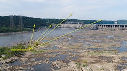
With safety, cost and conservation considerations in mind, the Electric Power Research Institute (EPRI) initiated a UAS line marking project with Exelon Corp. and EDM International Inc. The study was conducted at Exelon’s Conowingo hydroelectric generating station on two PECO transmission lines and one Potomac Electric Power Co. (Pepco) distribution line crossing the 3000-ft (914-m) wide Susquehanna River.
Challenging Logistics
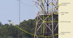
Project logistics were daunting, and installation required long flights to and from the lines being marked. The distribution spans were configured as transmission spans (including an overhead shield wire and lattice towers) to accommodate the long length of the river crossing. This site and these spans were selected because bald eagles nest semiannually on the towers supporting the spans, roost communally in the forest nearby and forage regularly on fish at the base of the Conowingo Dam.
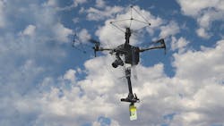
A small UAS (sUAS), the DJI Matrice 210 was modified to carry a line-marker installation arm designed to install P&R Technologies’ FireFly HW line markers, FireFly FF line markers, BirdMark line markers, QuickMark low line markers and SpanMark low line warning flags. The installation arm hung below the Matrice 210 to maximize separation between the aircraft’s rotors and wire being marked. For this project, FireFly HW line markers were installed to limit the potential for consistently high winds at the site to move or dislodge the line markers after installation. Each line marker included two retroreflective panels, orange on one side of the marker and yellow on the other, as well as two luminescent panels, one on each side, which the manufacturer stated would glow in darkness for up to 12 hours after a day of exposure to sunlight.
Four launch-and-land locations were used to access the six spans marked. Each location provided access to specific parts of the line. One launch-and-land location was a grassy area on the southwestern bank of the Susquehanna River, at the southeast end of Conowingo Fisherman’s Park. Another was a paved observation deck at the northwest end of Conowingo Fisherman’s Park. A third launch-and-land location was a concrete platform at the base of the downstream side of Conowingo Dam, and a fourth was on the rocky northeast bank of the Susquehanna River.
Efficient Flights
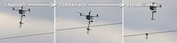
For each launch-and-land location, a pilot in command and visual observer coordinated to assemble the aircraft, plan flight lines, load a line marker on the installation arm, navigate to the power line span being marked, install the line marker, return to the launch-and-land location, reload the installation arm while the sUAS hovered to repeat the process and then eventually recover the sUAS when the battery was depleted. During installation, the pilot in command focused exclusively on the live feed from the sUAS on the controller’s screen while the visual observer verified contact with the line, called out nearby birds in flight and helped to direct nonparticipating observers away from the pilot.
Over the course of a five-day period, 144 line markers were installed on the overhead shield wires of four transmission spans and two distribution spans. Each installation day lasted approximately eight hours, with the sUAS in flight for a total of four hours. Periods when the sUAS was not in flight were occupied with sUAS setup and breakdown, changing and charging batteries, safety meetings, explanations of the project to nonparticipants, and physically carrying the sUAS, line markers and associated components to launch-and-land locations — including up to 1700 ft (518 m) over an unmown transmission right-of-way.
The UAS was not affected by magnetic fields around the conductors or by current flowing in the overhead shield wires. Nor was installation success affected by the distance between launch-and-land locations and the line being marked (up to 1700 ft), or the angle of the line relative to the launch-and-land location (perpendicular to some spans and parallel to others). However, efficiency was affected by these factors because the UAS could install line markers more frequently when it needed to commute only a short distance from the launch-and-land location to the center of a span.
Lessons Learned
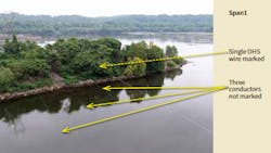
This project has resulted in important lessons learned. For example, the depth of sag in the span affected how steeply the ends of the span approached the tower and, consequently, impacted the sUAS ability to mark the entire span. Whereas the sUAS was able to mark the midspan portions of each span successfully, marking the steep, upper catenary curve near the transmission towers was not always possible. This may require modification of the payload design and sUAS used to carry it. More efficient sUAS targeting and camera system payloads also could reduce the considerable pilot skill required for successful installation.
In addition, changes in clamp design could eliminate problems. Small wooden dowel rods were used to keep the clamps open until contact was made with the static or conductor line. The rods tended to snap when damp, which resulted in dropping and losing numerous markers.
Another lesson learned: Starting installations at dawn proved to be crucial because that was when winds were calmest at the site, and high winds reduced efficiency.
During the course of the project, key crew resource parameters that contributed to success were noted. For example, the minimum flight crew should consist of a pilot in command and visual observer provided by the UAS team, and a communication specialist provided by the electric utility.
As in other UAS missions in the electric industry, the pilot in command must be able to focus exclusively on flying the aircraft. When the sUAS is in flight, the pilot in command should avoid conversation with anyone not part of the flight crew. The visual observer should watch each installation by eye, binoculars or spotting scope to confirm line marker installations and provide feedback to the pilot in command, who focuses almost exclusively on the live feed from the UAS camera.
The visual observer also should prepare and load each line marker as well as rotate batteries through the charging cycle as batteries are used. When the UAS is in flight, the visual observer also should avoid conversation with anyone not part of the flight crew. The communication specialist should be positioned to the rear of the pilot in command and visual observer to provide explanations to passersby or other utility personnel interested in the project.
In the end, this project demonstrated UAS can be used to install line markers on power lines. This approach is safer than helicopter installations because no personnel are airborne in proximity to power lines. The use of UAS likely is less disturbing to wildlife and the public. It is significant to note the frequent UAS flights to and from the power line did not appear to disturb numerous black vultures, bald eagles and other birds present in the area in the least. It is likely the factors currently driving up costs of UAS installation of line markers and driving down efficiency will be addressed as the art and science of using UAS to install line markers matures.
Acknowledgment
The EPRI team wishes to thank Rita Collins of EDM International for her work as a UAS visual observer during line marker installation and Paul Adair of Exelon for organizing and managing logistics at the work site. Contributions from Exelon, Baltimore Gas and Electric Co., Delmarva Power, PECO and Pepco made this project possible.
For more information:
DJI | www.dji.com
P&R Technologies | https://pr-tech.com
About the Author
John C. Acklen
John C. Acklen is a principal technical leader at the Electric Power Research Institute (EPRI). He holds BA and MA degrees in anthropology from Rhodes College and the University of New Mexico and is a registered professional archaeologist. Acklen manages the Transmission and Distribution Environmental Issues program at EPRI. Current areas of research include tools to effectively manage PCBs, wood pole disposal, integrated vegetation management (IVM) techniques and biodiversity, environmental issues associated with transmission line siting and resource protection during construction and maintenance, environmental applications for small unmanned aerial systems (drones), and the development of tools to reduce avian and other animal interactions at utility facilities.
James F. Dwyer
James F. Dwyer, PhD, is a certified UAS pilot, certified wildlife biologist, and research scientist at EDM International, Inc. He works with electric utilities throughout North America and Europe to develop decision-relevant UAS operations and wildlife conservation research. He volunteers time for the Raptor Research Foundation as an associate editor, Conservation Committee Chair, and Code of Conduct Committee founding chair. Dwyer focuses on addressing wildlife conservation and management needs for the industry.
Keith Kowalski
Keith Kowalski is a Pennsylvania professional geologist and manager of environmental management at PECO, an Exelon Co. based in Philadelphia, Pennsylvania. Kowalski received his B.S. in geology from Long Island University, Southampton College. He is responsible for maintaining ISO 14001 compliance of the Environmental Management System at PECO within the 2100-sq mi service territory. In 2016, he won the EPRI Technology Transfer Award for development of a statistical method predicting PCBs in electrical equipment. Additional responsibilities include management of the avian, stewardship/biodiversity, spills, greenhouse gas, permitting, remediation and waste programs.
Jesse Goldberg
Jesse Goldberg is a senior environmental program manager with PECO Energy Co. (PECO) in Philadelphia, where he manages the Avian Protection Program, and the Natural Resources Permitting and Compliance and Right-of-Way Dumping programs. He graduated from the Pennsylvania State University in 1988 with a B.S. in Environmental Engineering, and earned his master’s in engineering science with an environmental plan of study in 1998, also from the Pennsylvania State University. He has over 30 years of professional experience working in the water and wastewater fields performing permitting, compliance, and operational troubleshooting for a governmental regulatory agency, and public and private entities.