Standardizing Underground Data to Reduce Utility Strike Risk
Key Highlights
- MUDDI provides a harmonized, flexible data model that standardizes underground asset information across different organizations.
- The UK’s NUAR project demonstrates MUDDI’s effectiveness in reducing excavation risks and improving infrastructure planning.
- Implementing MUDDI can lead to significant cost savings, enhanced safety, and increased reliability for utility operations.
- The framework’s modular design allows it to evolve with emerging technologies and infrastructure needs.
- Global interest in MUDDI is growing, with potential applications in flood risk management, land ownership, and climate resilience planning.
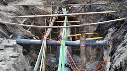
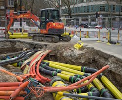
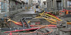
When a utility crew rolls up to a busy intersection, they’re not just cutting into asphalt — they’re cutting into uncertainty. Buried beneath the surface might be a century-old water main, a fiber-optic line installed last month or an unmarked power cable that could knock out service to thousands. Every year, these “strike incidents” cost utilities billions in delays, lawsuits and emergency repairs — not to mention the risk to workers’ safety.
For decades, engineers have been trying to answer a simple but stubborn question: What exactly is under our feet?
A breakthrough is now taking shape. Known as MUDDI — short for the Model for Underground Data Definition and Integration — this new framework is giving utilities a common language for underground data. The Open Global Consortium (OGS) is spearheading this global effort, and experts from across the world have shaped its design.
MUDDI principles are already being applied in the United Kingdom’s (UK’s) National Underground Asset Register (NUAR), which is bringing together data from more than 650 utilities and asset owners to reduce excavation risks and improve infrastructure planning.
Why This Matters to Utilities
Utility executives don’t need another acronym — they need fewer strikes, faster repairs and better coordination with other asset owners. That’s where MUDDI comes in.
Instead of every gas, water, electric and telecom company keeping their own incompatible maps with each using different terms, formats and coordinate systems, MUDDI creates a harmonized data model. Think of it as “Google Maps for the underground,” where all pipes and cables are described in the same way and displayed in the same frame of reference.
The payoff is straightforward:
- Safety – Fewer worker injuries from unmarked lines.
- Reliability – Reduced outages from accidental strikes.
- Efficiency – Crews spend less time reconciling conflicting maps and more time fixing problems.
- Cost savings – Avoiding surprise encounters with hidden infrastructure prevents multi-million-dollar overruns.
As Chris Popplestone, senior data scientist at Ordnance Survey, explains, “The harmonized data model is that central target into which all the source infrastructure data is transformed. The source data comes in all different shapes and sizes, but it all gets transformed to this harmonized model.”
So utilities don’t have to change how they collect data. MUDDI takes care of the messy translation, ensuring everyone can work from the same page.
Proof in the Ground: The NUAR Case
The UK has become the world’s test bed for this idea. Starting in 2019, the UK Government Digital Service (part of the Department for Science, Innovation and Technology and previously known as the Geospatial Commission) launched pilots in London and Northeast England. The goal was to prove that hundreds of asset owners could pool their records into a single system built on MUDDI principles.
It worked, and today, the National Underground Asset Register (NUAR) is live in Public Beta with data from more than 300 asset owners, ranging from national-scale utilities and telcos to local authorities. Engineering firm AtkinsRéalis led the national rollout of NUAR as a minimum viable product to test it at scale, while software company 1Spatial has been handling the complex data transformation and ingestion. Ordnance Survey shaped the harmonized NUAR data model, built the underlying data store and developed the user interface. It now operates NUAR on behalf of the government with the platform fully operational at the end of 2025.
The result is that field staff can now draw a polygon on a digital map where they plan to dig and instantly see every pipe and cable that might be affected — presented in a clear, uniform way regardless of who owns it. Popplestone, who specializes in geospatial data modeling and harmonization, said the NUAR pilot was based on an earlier version of MUDDI.
“The feedback we got from that pilot has fed into a new iteration of the model, which is now forming the basis of the national rollout,” he said.
Tackling the Messy Middle: Data Chaos
Getting to this point wasn’t easy. One of the toughest challenges wasn’t technology — it was terminology. The same type of pipe might be described differently by two companies, or even by the same company in two different regions. A fiber-optic line in West Sussex might be recorded in a completely different way than the exact same cable in West Lothian.
That’s where MUDDI’s flexibility comes in. Carsten Roensdorf, NUAR product manager at Ordnance Survey and co-chair of the OGC MUDDI Working Group, puts it this way: “There is potentially so much variation that we have to be able to make tweaks and add things we haven’t come across in other data sets. The data model has to be modular and responsive — otherwise it collapses under the weight of exceptions.”
In practice, this means NUAR’s “excavation profile” was built with governance structures that allow new asset types or terms to be added without tearing down the whole system. The model can evolve as new technologies or infrastructure emerge, ensuring it stays relevant for decades.
Beyond Digging: New Horizons for MUDDI
While safe excavation was the first use case, the applications go much further. The same harmonized approach could help utilities and governments manage flood risk, track land ownership or even coordinate climate resilience planning. Anywhere multiple organizations need to pool different datasets into a single, reliable view, MUDDI offers a template.
As Roensdorf explains, “Voices at the Open Geospatial Consortium that helped shape and influence MUDDI come from as far and wide as New Zealand, the Netherlands, Belgium, the United States, Canada and Scotland. That breadth gives MUDDI a great chance to succeed globally.”
For utilities facing cross-border projects, multinational investments, or the rising demands of regulators, that global outlook matters.
Executive Takeaways: Why MUDDI Matters for Utilities
- Billions at stake. Utility strikes cost more than $30 billion annually in the United States alone. Some studies place the broader impact at more than $60 billion.
- One language underground. MUDDI harmonizes asset data from hundreds of owners into a single, trusted view.
- Proven at scale. The UK’s NUAR system is live with 650 asset owners, reducing risks and delays for field crews.
- Flexible by design. MUDDI is built to adapt to new asset types, regulations and technologies without breaking the model.
- Beyond digging. The foundation for disaster response, digital twins and smarter infrastructure planning can be used worldwide.
Why Executives Should Care Now
The risks of inaction are high. In the United States alone, the Common Ground Alliance (CGA) estimates that damages from utility strikes cost around $30 billion each year in direct and indirect expenses — covering everything from emergency repairs to lawsuits, lost productivity and insurance claims.
Some industry studies suggest the broader economic toll may be even higher — potentially exceeding $60 billion annually when factoring in construction delays, private-line strikes and systemic inefficiencies. Regardless of which estimate you choose, the bottom line is clear: the costs are measured in the tens of billions every year.
And that’s only the financial side. Utility strikes also put lives at risk. Industry data indicates that excavation-related incidents in the United States result in more than 2,000 injuries and about 400 deaths each year.
The business case for harmonized underground data, then, is not only about saving money, it’s about protecting workers, reducing liability and preserving public trust.
Lessons from NUAR
NUAR offers several takeaways for utilities watching from abroad:
- Leadership matters — Government Digital Services played a convening role, but it took engineering leaders like AtkinsRéalis and technology providers like 1Spatial and Ordnance Survey to execute.
- Start small, scale fast — The initial pilots provided proof, but feedback loops drove the model’s refinement.
- Flexibility is key — No two asset owners describe their systems in the same way. The model has to accommodate differences without breaking.
- Engagement builds adoption — 650 asset owners didn’t sign up overnight. Consistent outreach and collaboration were crucial.
The Road Ahead
As NUAR expands across the UK, interest in MUDDI is growing worldwide. Countries facing fragmented underground infrastructure records — from North America to Asia — are exploring whether the model could help them avoid the same costly headaches.
The hope, says Roensdorf, is simple: “With the progress MUDDI is making underground, engineers of the future will endure much milder headaches while pondering how to dig up street corners in years to come.”
For utility executives, the message is clear: the underground is no longer a blind spot. With harmonized data models like MUDDI, the industry finally has the chance to see beneath the surface and act with confidence.
Editor’s Note: Chris Popplestone and Carsten Roensdorf contributed to this article.
About the Author
Scott Simmons
Scott Simmons is chief standards officer at the Open Geospatial Consortium (OGC), where he leads the global standards program that enables interoperable geospatial data and services across sectors. He oversees OGC’s consensus processes, coordinates with governments and industry and guides the evolution of OGC Standards and Profiles used worldwide.