Buried Markers Simplify Vegetation Management
Line maintenance, access for restoration and vegetation control along transmission rights-of-way (ROW) can present complex challenges. Ameren, for example, faces variations in vegetation, easement language, environmental restrictions and topography along its 8,000 miles of high-voltage transmission line.
To handle the challenges of vegetation management effectively, Ameren’s transmission operations department has implemented a new approach to marking property corners, easement details and ROW lines. This new method gives the utility permanent, indestructible ROW marking and a convenient, accessible database of easement details.
The Challenges
Ameren’s transmission lines pass through rural regions and dense, urban areas with as many as 70 individual property easements per mile. Each of these property owners may have concerns and opinions about the manner and method of vegetation management, including mowing, trimming, tree removals, herbicide use and ROW access. Such concerns are addressed individually in the course of day-to-day vegetation control and transmission line maintenance.
Adding to the complexity, differences in easement widths can vary, even on the same ROW. For example, although the nominal ROW width is 100 ft for lines operating less than 200 kV, and 150 ft for 200 kV and greater, older easements often have different widths.
As part of its ROW vegetation management program, Ameren must not only trim trees but also keep the easement area free of hazards and control other vegetation. To operate efficiently, Ameren workers must have access to precise and accurate property easement details in addition to other pertinent information or restrictions along a route in real time.
When present, the Ameren standard easement language gives the utility the ability to manage vegetation without restriction to ensure safety and reliability as well as to be sensitive to landowner concerns. The utility often needs to work collaboratively with owners to establish best management practices for dealing with vegetation so landowners, wildlife and Ameren can coexist in a sustainable manner on the ROW.
Exploring Solutions
Ameren’s conventional method for recording and marking easements, and the associated important easement restrictions along the ROW, has been to place stake markers, which are then associated with recorded details about each property segment in a central record repository. The stake markers have limited life since they are easily lost to erosion, mower damage or intentional removal. This necessitates frequent and costly resurveying when boundary disputes or construction occur and can delay work along the line.
The new marking project began with a serendipitous association between the radio-frequency identification (RFID) markers used for security and inventory management of retail products and the challenges of power line ROW management. The Ameren staff then discovered an RFID technology that could meet its ROW marking needs. Underground markers already are used to define buried utility components, but this marking method had not yet been adopted for survey purposes other than specific buried equipment.
Investigating Buried Markers
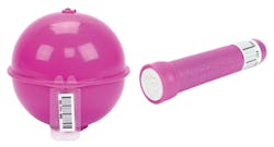
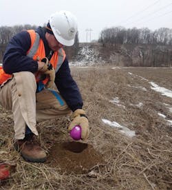
The Ameren team contacted 3M’s locating and marking group to explore the buried marker concept. 3M’s Electronic ID Marker System features plastic housings with non-powered and no-maintenance circuit components that can be programmed individually with useful details before they are dropped into a trench or small hole and then backfilled.
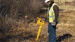
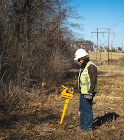
Later, a portable locator transmits a RF signal to the buried marker, which responds by reflecting the stored data back to the operator. This information can include the easement width, voltage level, utility description including restriction information, placement date and other details pertinent to the application. Buried markers are available in several sizes and shapes, depending on the placement depth needed.
Ameren learned that up to 100 characters of data specific to its transmission line ROW interests could be programmed into each 3M buried ID marker. Through the use of codes and an integrated asset management system, Ameren could replace the transitory stake markers at property corners, easement lines and ROW borders with permanent underground reference points. Buried ID markers allow for survey-grade location precision and provide crews with information they need to comply with changing requirements along the route.
The Ameren team worked with 3M to establish coding parameters for buried marker memory content. Stored data includes defined points where mowing, herbicide use or aerial trimming are restricted, as well as permitted encroachments for equipment access, pre-notification information, restrictions and other information. The utility began implementing the new ID marker program in April 2012.
Installing the Devices
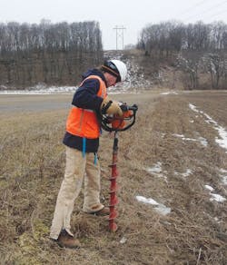
Ameren uses two types of 3M markers: small tubular near-surface devices called “carrots” that are placed at a depth of about 24 inches below grade in non-tilled areas, and 4-inch-diameter ball markers, which are placed at a depth of 4 ft to 5 ft in cultivated areas. These markers define the edge of the ROW along both sides, generally at changes in property ownership but more frequently if the properties are large.
Each marker is custom programmed and placed by a survey contractor. The GPS coordinates for markers also are recorded. GPS receivers generally have an accuracy of about ±9 sq ft, and this information can rapidly direct a field worker to the general area, where markers can be found quickly using 3M’s marker locator, which has virtually pinpoint accuracy.
Buried markers are programmed and placed by registered land survey contractors, based on Ameren training tools developed cooperatively with 3M. The utility’s RFID marker program is currently underway in projects involving new construction as well as those with significant rebuilding, and also is used in areas where easements are being acquired to widen ROW. About 20% of the utility’s transmission line miles have the ROW defined with RFID markers to date.
Ameren developed and uses a transmission asset management system for asset management, vegetation management, line routing, operations and contact history related to its transmission facilities. This geographic information system incorporates details for every system component and is valuable emergencies. The new ID marker components and individual programmed codes are included in the TAMS database and should help establish the ROW during restoration situations.
Leveraging Benefits
Marker placement is an incremental job, but Ameren is making progress with the implementation. The utility has already reaped the benefits of marker accuracy and permanence. The devices not only reduce the need for future surveys, but they can also save time and money and shorten restoration time because of the reliability of ROW access information.
Through precise marking, the utility can perform vegetation management work right to the edge, even where the ROW is irregular, with much less chance of unwanted contact outside the ROW. Once in place, the buried markers are unseen, are invulnerable to mowing damage or intentional removal, and the stored data is authoritative. Surveyed and marked boundaries are legally binding without follow-up surveys, which simplifies the resolution of property owner disputes.
Because the markers are reprogrammable from the surface, the system is flexible enough to change as ownership or easement language changes. This results in simpler and more efficient work for Ameren field crews as well as substantial electrical transmission line ROW management savings in both time and expense.
Jeff Hackman ([email protected]) is the senior director of transmission operations for Ameren Corp.
Mary Hetz ([email protected]) is the manager of transmission vegetation management for Ameren.
Mentioned in this article:
Ameren | www.ameren.com
3M | www.3m.com
Advances in Buried Marker Technology
Utilities have used buried markers for decades to pinpoint the location of underground facilities. The first such markers were passive, only providing data to precisely mark a location. Excavation was required to determine what was buried at that point.
In 2002, 3M’s locating and marking group introduced active buried radio frequency identification (RFID) marker technology to both pinpoint a location and provide details specific to that location. Active 3M markers are programmed as they are placed and can be found and read later using a handheld locator. Each marker has a distinctive serial number that can be used to identify its location in a geographic information system database.
The markers use circuits that require no power source or maintenance. They are energized solely by electromagnetic energy received from the interrogating marker locator. Details recorded on the markers can include a description of the buried object like the splice, valve, waste line and stub, its buried depth, the utility owner, date of placement or other useful data. Electronic marking provides an accurate and reliable means for point location not affected by soil conditions, surface threats, nearby utilities or temperature extremes normally found underground.
The markers come in several formats, each designed for particular applications, terrain and depths. They are supplied in seven standardized radio frequencies and housing colors established by the American Public Works Association, one for each category of underground utility. In addition to Ameren’s purple general-purpose markers, individual models are color-coded for other utility categories.
Locators used to find 3M ID markers may serve multiple functions. For example, some units handle cable path tracing and fault location as well as marker locating and programming. This integration helps to minimize the number of tools required for daily work.
