Eye in the Sky: Drones Provide Aerial View of Storm Damage
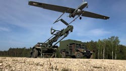
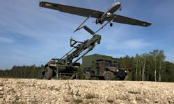
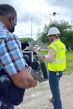
From hurricanes to ice storms—and everything in between—linemen have seen their share of severe weather over the last few years. Fortunately, new technologies have not only expedited storm response, but they have also improved safety during the restoration process. For example, many utilities and line contractors now have a new technology in their toolbox to more accurately pinpoint damage and assess the amount of destruction in the aftermath of a severe weather event. Unmanned aircraft systems (UAS), commonly known as drones, have reached new heights in the electric utility industry due to their portability and versatility.
“The drone world is in its infancy, and we are primed and ready for the growth and continuous expansion in the realm,” said Chris Sorrentini, project superintendent and head of the drone division for BHI Energy in West Palm Beach, Florida. “The sky is the limit.”
The following companies have used drones to slash the time required to get the lights back on and ensure their linemen come safely to their families every night.
FirstEnergy: Analyzing Aerial Data
FirstEnergy is leveraging the technology of drones as an additional tool for storm response. After major storms, the team uses drones to help assess damage, looking for downed wires, broken structures or problems challenging to detect from the ground. Because drone crews are on the ground instead of a helicopter or bucket truck, the utility minimizes safety risks during the assessment process.
“We have been able to use drones to access areas that were inaccessible by foot,” said Randy Inman, supervisor of the drone program at FirstEnergy. “In the past, this would have made the process of assessing damage much more difficult. With drone technology, however, our team is able to capture images from a safe, accessible distance. This gives our crews valuable information, expediting the restoration for customers.”
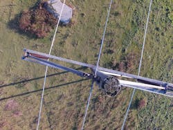
Drones give the team a much closer view of storm damage more quickly than traditional methods. The bird’s eye imagery in modern drones helps the team better determine what repairs are necessary and what materials are needed to make those repairs.
In addition to a live view, drones take still photos that can later be used to analyze and assess potential problems. This saves time, allowing the utility to dispatch the correct tools, equipment and crew members to repair the lines and expedite the restoration process.
“In an emergency, the safety of our customers and first responders is our top priority, and drone technology is an important resource,” Inman said.
According to Don Bernier, captain of flight operations for FirstEnergy, drone technology is an effective way to get data back to event decision makers.
“The time saved is dependent on the event, but drones are a safer, faster way to collect data necessary to assess problems and make repairs,” Bernier said.
As drone technology has evolved, so has FirstEnergy’s processes for selecting which equipment to use in a given situation.
“Certain drones are rated for weather resistance and others are more stable in gusty weather,” Bernier said. “We carefully assess the conditions before dispatching crews and equipment for storm response.”
FirstEnergy has assembled a team of 15 licensed drone inspection pilots prepared to assist in storm response, all of whom receive ongoing training and field experience to help ensure the team is prepared to meet customer needs. Though storm response is covered in the utility’s comprehensive two-week drone pilot course, those who would report in the field complete additional damage assessor training.
In addition to traditional personal protective equipment (eye protection, hard hat, appropriate footwear, first aid kits, and fire extinguishers), drone pilots involved in storm response are equipped with flame-resistant rated clothing and personal voltage detectors to help ensure their safety.
FirstEnergy relies on solid program standard operating procedure processes for every flight. For example, storm response is specifically identified in FirstEnergy’s pre-flight risk assessment process. Before each flight, the team goes through a checklist to review goals and assess risk.
While Inman and Bernier say the industry is pushing for more autonomous operated drones, FirstEnergy’s methodology is driven by the need for situational awareness in a dynamic environment. For that reason, the utility requires a drone crew of more than one person.
“A two-person team is better able to perform this work, because the pilot in command is focused on safely flying the equipment while a sensor operator is responsible for data capture,” Bernier said. “This helps each focus on the task, improving the quality of the assessments.
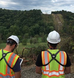
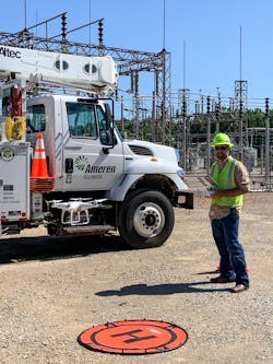
Ameren Illinois: Expediting Restoration
At Ameren Illinois, a blend of linemen, operations, vegetation and safety supervisors and engineers serve as drone pilots. As the utility moves into the fifth year of its drone program, it is looking to add operations field personnel to the mix, said Paul Stegmaier, supervisor, Construction Services, Ameren Illinois.
Currently, 42 pilots across Illinois are on a call list to be dispatched wherever they are needed. Pilots will provide live streaming data to key operations personnel in areas blocked by debris or not easily accessible by conventional methods.
Typically, in a storm-specific setting, operations supervision or crew general foremen will directly review the incoming live data to assess all safety concerns, identify the need for any specialized materials and strategize their approach based on the first-hand perspective the drone provides, Stegmaier said.
“In less than an hour’s time, high-level data can be evaluated to determine how many poles we will need to source, what obstructions are in the way requiring specialized equipment and what sort of manpower will be necessary to seamlessly facilitate the restoration of customers’ power,” Stegmaier said.
Over time, as the utility has continued to refine the program, the use of drones has specifically grown in line with
advancement of drone technologies.
“Weather resistance, zoom capabilities, interchangeable sensors, ease of deployment and use, are all contributing factors to widespread acceptance and integration,” he said.
Wes Burris, senior safety supervisor, Ameren Illinois, recalls one particular storm in which drones helped to expedite restoration. In the utility’s northern region, near
Ottawa, Illinois, a crew from outside the area had responded to an outage in the country.
“This area was heavily wooded, and the damage kept our trucks and equipment from getting through and inspecting the line,” Burris said. “Rather than waiting for a tree crew to clear a path to get by, we were able to utilize the drone in this situation.”
With the drone, the team was able to quickly get it up the air and secure an overview of where the backbone line was
and how many ways it branched off.
“What could have taken an hour or more to walk out to drive through was accomplished in less than 20 minutes,”
Burris recalled. “It also gave the crew on site a sense of how important it was to get this particular span of line rebuilt.”
Earlier this spring, he also remembered a time when Ameren Illinois received heavy rain, and the local creeks were flooded near Aviston, Illinois. A line coming out of a substation and crossing through a creek bottom experienced an outage. “This particular creek bottom was flooded out at the time, but the crew needed to somehow visually inspect this area of the circuit,” Burris said. “We were able to fly the drone down this span and inspect to determine the problem was located in the area flooded by recent rains. The crews used a boat to make the repairs, but utilizing the drone saved the time of making the trip twice to inspect this area of the circuit.”
Looking forward, Stegmaier forecasts exponential growth for drones. “There is a direct correlation between the use of drones and infrastructure reliability,” he said. “Additionally, more business segments will begin to recognize the potential return on investment, finding creative ways to integrate the use of this still ever-evolving technology.”
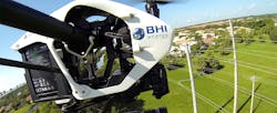
BHI Energy: Elevating Damage Assessments
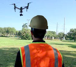
Before drone technology, a ground team of two linemen had to follow a circuit map and walk a section of line to look for signs of damage. Once the assessment was complete, they had to walk back the same way to get back to the truck and ride to the next site. Today, with its six licensed drone pilots, BHI can capture imagery quickly and reliably without stepping foot on damaged areas.
“A team of two linemen walking a section for damage requires walking through debris which could hide hazards.” Sorrentini said. “By utilizing drones, you do not have any linemen or damage assessors physically entering the area that could have wires down or other unsafe situations. A drone team can capture the entire area remotely avoiding all hazards while still collecting imagery from above, which can provide details not even seen from the ground.”
With drones, BHI can set up shop in one central location and fly multiple segments at once. Sorrentini estimated the time savings can range in the ballpark of 50 percent to 75 percent, which is dependent on various factors.
Through the use of drones, BHI has the capability to quickly and safely scan and data capture any areas of interest through use of various sensors like photos, thermo images and/or LiDAR. The company has developed a platform, which allows the data to be easily seen by all required parties.
“Our platform allows linemen to be able to quickly scan any findings our drone teams may find and accurately plan for required repairs,” he said. “Training is as simple as a brief walkthrough of the platform, which is very user friendly.”
Newer technologies and increasing demand constantly require continued training to stay ahead of the game and provide the most accurate and reliable data possible, he said. Today, using the drones, BHI can identify damage even prior to storms.
“These would have been an immediate outage even in the smallest of storms,” Sorrentini said. “During storms, drone use can capture all these pictures of an entire line and quickly scan on the return of the drone.”
In his view, drones are ever expanding in the realm of possibilities to replace helicopters for safety, cost and productivity purposes. At BHI, he is working on continuously growing the number of drone pilots and further increasing the capability of the drones.
“I see a future where drone flights are scheduled on a routine basis with machine learning to capture the same images of any points of interest and constantly monitor high demand lines and/or other critical infrastructure lines,” he said.
Evergy: Improving Linemen’s Safety in the Field
Not only BH, but also Evergy’s field workforce once walked the line or drove through the right-of-way as the primary means of damage assessment following storms. Back in 2015, however, the utility first started investing in drones.
“With a drone, you can get is out of the back of a truck after the storm passes and be down the line in less than five minutes,” said Mike Kelly, senior UAS coordinator at Evergy. “You can take pictures and videos to have on file and relay information back to the service center so our linemen can pick up materials and get things in line to make repairs in the field.”
A few years ago, a snowstorm blanketed the Kansas City area. In turn, Evergy could fly the drones in the urban areas with wet, heavy snow.
“We flew down the lines to see where the branches may have broken off and come into contact with the lines to help identify the issues more quickly,” he said. “By using the drones like a scout, we were able to have the linemen focus on repairing issues versus trying to troubleshoot where things were down.”
Evergy is using drones in conjunction with line sensors to determine the exact location of a fault or outage. When an object, like a tree limb, strikes a power line and causes an outage, the communications technology alerts the utility, which can then send out a drone team for further assessment.
“UAS is one of the newest pieces of technology we are starting to implement to help in the efforts in conjunction with the sensors on the line,” Kelly said. “We are actively looking for what caused the fault or outage with our drones, which is a lot safer than traditional means.”
In Evergy’s service territory, linemen must monitor and maintain lines running through rural and urban areas. With the drones, the field crews can determine what lines are down and what caused the outage.
“We have a lot of blind runs of lines that go on for miles in our rural areas, and they’re sometimes hard to access by foot, and there are no roads,” Kelly said. “Drones are perfectly suited for these types of areas. They also work in urban areas with alleyways, and they’re smaller and less intrusive than other methods.”
When Evergy first launched its drone program, the primary consideration was safety. The impetus for the program grew out of the transmission maintenance department. “Large, high-voltage lines are sometimes hard to inspect because they are so big and there is a high amount of voltage going through the lines,” Baker said. “We are now using drones to perform visual inspections on transmission lines.”
When Evergy first started exploring the possibility of drones, the utility reached out to a local university in Salina, Kansas, Kansas State Polytechnic, which has a UAS program.
“They were one of the leading subject matter experts within our area, and they were right in our backyard,” Kelly said. “They had a lot of experience in the area of UAS, and they helped to get our program off the ground.”
The utility then collaborated with other utilities, which shared their best practices. “We saw what has and hasn’t worked with other utilities,
and then we solved those common problems together through industry events and other groups.”
For example, Evergy is actively participating in an industry-wide projects like participating in a pilot program to fly drones beyond the visual line of sight. While Evergy does not hold a waiver at this point, the utility is participating in the “Beyond” program through the Federal Aviation Administration.
During its infancy of its drone program, one of the main challenges Evergy faced was regulatory issues. “It is a lot less restrictive today, but there are still things that do restrict us,” Kelly said. “Early on, you had to be a licensed pilot to fly a drone commercially, which was restrictive. They have now relaxed that rule and have a certification process for those of us who want to fly drones commercially.”
Evergy has trained eight field personnel, but not lineman specifically; four wind techs, two GIS personnel, and two T&D supervisors.. In the future, Kelly said he wants to get the drones in the hands of those who can use the technology in the field to make their work safer and more efficient.
“We haven’t gotten to that point yet where we are training our linemen,” he said. “We are actively working on getting a solid training regime in place so we can send our linemen through the program and get them certified and ready to go. Right now, we are training other groups, but when we are ready to pull the trigger and go, we want to get a lot of linemen in our service territory trained so it can help them in their everyday jobs.”
Evergy is using the drones for not only storm assessments, but also to identify possible issues on the line during routine inspections. Local supervisors and foremen can analyze the imagery to prioritize the rights of way. Also, Evergy is using drone technology for mapping right of ways before rebuilding the line or doing a larger project.
“It helps us to create better designs of what the ROW was like before we built the line so we can restore it as close to it was before,” Kelly said.
In addition, Evergy is using drones to inspect inside power plants. For example, Evergy can deploy drones with a cage around them before it sends in personnel so they can be safer and more efficient. These drones have thermal capabilities and can scan for hot spots. “They can see anomalies we can’t see with the human eye that may become the cause of an outage,” he said.
Evergy is continuously finding new use cases for drones. “Almost every week or so, someone reaches out and said, ‘We have this idea. How can we do it with the drones?’” Kelly said. “We try to be as open as possible and collaborate with different work groups to leverage the technology better.”
Currently, Evergy has about 12 drones in its fleet, and its pilots operate multi-rotor aircraft and quadcopters in a range of sizes. The largest drone is 12 lbs fully weighted down, measures 2 to 3 ft in diameter and has 45 minutes of flight time, while the smallest drone measures about 8 in. in diameter.
Some of the drones owned by Evergy also have a water resistance rating. In the event of a torrential downpour or lightning, pilots must keep the drone safely inside and protected. If it is lightly raining after a storm passes, however, a pilot can safely fly the drone with certain precautions in mind.
“You can get some moisture on the lens, but at the same time, there is still a lot of value in getting power restored as quickly as possible,” Kelly said. “If you fly it in the rain and lose it, it’s definitely worth it to restore the customers’ power more quickly. At this point, however, we haven’t lost any drones yet. It proves to be pretty effective, and the technology keeps improving all the time, and drones are more adaptable to different kinds of weather.”
In the future, Evergy has plans to repeat its drone program. Kelly envisions having at least one to two drones in each service area for a total from 20 to 50 or more. He also envisions having a drone inside the substation to communicate with devices on the line that knows when to start looking for an outage.
“As time progresses and technology improves, the technology will help individuals in the field,” he said.
He said so far, linemen have positively responded to the drone technology.
“They like to see how Evergy is employing new technology to make their jobs safer and more efficient,” Kelly said.
About the Author
Amy Fischbach
Electric Utilities Operations
Amy Fischbach is the Head of Content for T&D World magazine and manages the Electric Utility Operations section. She is the host of the Line Life Podcast, which celebrates the grit, courage and inspirational teamwork of the line trade. She also works on the annual Lineworker Supplement and the Vegetation Management Supplement as well as the Lineman Life and Lineman's Rodeo News enewsletters. Amy also covers events such as the Trees & Utilities conference and the International Lineman's Rodeo. She is the past president of the ASBPE Educational Foundation and ASBPE and earned her bachelor's and master's degrees in journalism from Kansas State University. She can be reached at [email protected].