There’s an App for That: SRP's Mobile Software Solution
Like their peers at other utilities and government agencies, Salt River Project field employees have found creative ways to incorporate mobile technologies. An electric and water utility that provides service to more than 2 million residents in the metropolitan area of Phoenix, Arizona, U.S., Salt River Project (SRP) leverages smartphone-captured digital photos for a variety of purposes in many of its departments. Most noteworthy are the troubleshooting and line maintenance departments, which use field-captured photos to improve the utility’s responsiveness to power outages.
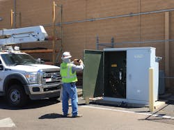
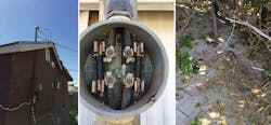
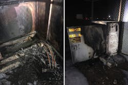
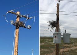
Troubleshooters are SRP’s first responders to outages. They are responsible for identifying the root cause of an outage and initiating work orders that trigger repair and replacement of damaged infrastructure. During the initial outage triage, SRP troubleshooters capture photos that are sent to the assigned line maintenance crew to give a clear picture of the damaged assets. This improves the crew’s ability to arrive on-site with the needed materials, equipment and expertise to complete infrastructure repair or replacement activities.
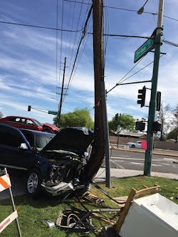
Line maintenance crews also capture photos of work in progress during prolonged power outages and severe weather events. These photos are sent to the SRP media relations team, who shares them with the general public through local news outlets and social media. The troubleshooters’ photos are provided to the SRP damage claim and legal departments to document incidents for which SRP should be reimbursed or may be subject to litigation. With many use cases, photos are important digital information assets to the utility. For this reason, SRP has implemented a software solution, with a mobile application, to streamline and improve the capture, upload, storage and management of photos taken by field employees.
GeoTAP Solution
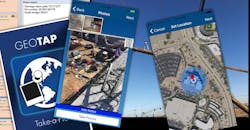
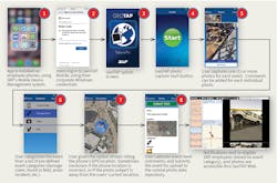
Coined GeoTAP by SRP staff, the geographic take-a-picture software solution includes both web and mobile applications. Installed on smartphones, GeoTAP Mobile is integrated with the phone’s camera, which enables field employees to capture photos directly within the app. Photos are grouped by event and can be categorized by field employees. GeoTAP Web is used by recipients of the photos.
Comments can be captured for each event and every photo. The app uses an interactive map to enable field employees to override the computed location of the global positioning system (GPS). Date, time, current user and location (X-Y coordinates) are captured for all events and photos. Unlike an email-based photo transfer process, the app supports an unlimited number of photos for each event. When all photos are captured for an event, the field employee uploads the photos and data to the SRP central photo repository using a cellular network. This upload is triggered simply by tapping the mobile app’s submit button, replacing the cumbersome email-based process used prior. Photos are stored within the app’s internal database, not the phone’s camera roll. Photos also are removed from the mobile device after the upload process is complete.
When the information is received by the back-end photo repository, GeoTAP then leverages the chosen photo categories to send email-based notifications to designated SRP employees. These employees are the recipients of the field-captured photos and can access them through GeoTAP Web. Recipients can view and edit the captured photos and associated data. The photos and data can be exported for an event; the export includes a folder that contains the event photos plus a formatted PDF that shows all photos and metadata. The exported data then can be imported as needed into other SRP applications, such as Maximo.
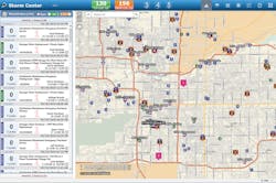
GeoTAP has been integrated with SRP’s Storm Center application, used by the line maintenance group for work prioritization and crew assignment. Events show up as pins on the Storm Center app’s interactive map, giving users direct access to captured information from their departmental application.
Best Use of Time
Prior to GeoTAP, SRP field employees used the built-in capabilities of their smartphones to capture photos but had to follow a multistep process to upload, store and send them to other SRP departments. Photos were sent by email. Field employees had to log in separately to the utility’s email application, compose a message and attach photos. However, they were limited to sending four or five photos per message. If photos needed to be stored permanently, field employees had to follow another process to upload the photos from their smartphones to a computer, rename them for searchability and transfer the files to a common network location.
These time-consuming multistep processes were a hindrance to field crews. Instead of being focused solely on working safely and restoring power to customers, field employees spent a lot of time navigating through various mobile apps and data-upload processes. The information captured with each photo was limited to the photo itself. Field employees had no way to categorize the photos or capture relevant comments. This limited SRP’s ability to use the photos as an information asset, because the data could be grouped or searched only by file name.
Additionally, many photos contained sensitive information, such as traffic accident reports that included private information like license plates, driver license photos, personal injury and avian incidents. Before GeoTAP, these sensitive photos were stored in an unsecured state on employee smartphones, with the risk of being shared inadvertently with unauthorized individuals or even being posted on social media.
Behind the Technology
GeoTAP Mobile was developed by SRP’s enterprise spatial and mobility services (ES&MS) team using the Xamarin mobile applications framework. The app runs on iOS and Android mobile devices, and it can be used on any company-issued or personal mobile device registered with Airwatch, SRP’s mobile device management system. The app automatically is installed on registered mobile devices using the Airwatch app catalog.
GeoTAP Mobile is secured by Microsoft Azure Active Directory (AD). Users log in to the mobile app using their corporate Windows login and password. The integration with AD means access to GeoTAP is revoked immediately when employees leave SRP for any reason or if they accept a job in another SRP department. The app also is uninstalled automatically by Airwatch if the user’s phone is out of compliance with SRP policies, such as the operating system being outdated.
GeoTAP Mobile uses its own local data storage and functions as a disconnected app, remaining operable even when the user has no cellular connectivity. The app’s data-upload process runs in the background, so users can continue using the app or any other apps when data uploads occur.
The web application is JavaScript based. Access to events and photos is controlled through Windows AD groups; access to each photo category depends on the user’s membership in the associated AD group. The web application includes an interactive geographic information system (GIS) map that enables users to search for and retrieve photos through a map-based interface. Each photo is stored at both its original resolution and as a lower-resolution thumbnail used to reduce the payload size when viewing photos. The original high-resolution photo can be downloaded at any time.
More Use Cases
GeoTAP originally was implemented for SRP’s troubleshooting, line maintenance, damage claim and legal departments in 2018. Since then, its use has expanded to the revenue protection, environmental and groundwater management teams. More than 200 users have logged 5000-plus events since the software was deployed.
The SRP revenue protection team uses GeoTAP to log power-theft incidents. The environmental team is the recipient of events that log avian incidents. Specifically, the event locations are helpful because wildlife agencies often are dispatched to an incident’s location while SRP crews are sent to bird-guard nearby poles and towers. Prior to using GeoTAP, these groups often struggled to find an incident’s location.
GeoTAP now is used at SRP for the following purposes:
- Power outages and service restoration
- Damage claim incidents
- Avian incidents
- GIS map and data errors
- Power-theft incidents
- Public relations and media releases
- Maintenance issues, such as found field.
Requested enhancements include the ability to relate events to Maximo work orders and assets as well as the ability to attach photos directly to the related Maximo work orders.
Acknowledgements
The author would like to acknowledge all the groups and individuals at SRP who contributed to the implementation of GeoTAP. Special mention goes to Principal Analyst Doug Bozzo and Team Lead Kenon Ronz for development of the GeoTAP Mobile app, the ES&MS team for development of GeoTAP Web, Manager SRP Troubleshooting Jeff Gaumann for providing user requirements and ongoing feedback, and Business Analysts Sheila Young and Courtney Jones for project management and user training.
Sidebar: Summarized Benefits
The GeoTAP web and mobile applications provide a variety of benefits to Salt River Project (SRP):
- Time savings for SRP field employees — The manual processes previously used to send, upload, rename and store photos were eliminated.
- Location and crew navigation — Event and photo locations make it easier for field crews to navigate to the desired location for power restoration, vegetation management and environmental activities.
- More pictures — It is easier for field crews to capture and send an unlimited number of photos for each event. This has resulted in more and better information being sent to recipients, enhancing their ability to do what they do.
- Real-time information for office employees — Information and photos are received in near real time by office employees who may be communicating directly with SRP customers, helping those employees provide accurate, up-to-date information.
- Reduced safety risk — Processes associated with capturing, sending and storing photos have been streamlined and simplified. This has reduced the level of distraction for field crews.
- Expedited service restoration — Captured photos help field crews to arrive on-site with the necessary equipment and materials needed to do their work, averting an extended wait for delivery of these items.
- Enhanced data-search capabilities — The captured data now includes relevant metadata, such as comments, location and categories, which improves the usefulness and searchability of the data.
- Improved information security — Photos and data are not accessible outside the app and the information is purged from the mobile device after upload.
- Improved information management — The app provides a common, cross-department repository for managing photos and associated metadata. This has replaced several disparate, unmanaged network directories used previously to store this information. This common repository improves SRP’s ability to enforce data-retention policy and respond to external information requests.
For more information:
AirWatch | www.air-watch.com
Microsoft | www.microsoft.com
SRP | www.srpnet.com
About the Author
Mark Ledbetter
Mark Ledbetter is manager of the enterprise spatial and mobility services group at Salt River Project (SRP), which he has led since 2005. His career experience also includes 12 years as geographic information system (GIS) manager and eight years as applications director for the City of Scottsdale, Arizona, U.S., as well as nine years as a GIS software developer at SRP.
