AI-Powered Drones for Nighttime Grid Emergency Response
Key Highlights
- AI-powered drones enable rapid detection and localization of faults in the power grid during nighttime emergencies, significantly reducing response times.
- Thermal imaging and high-resolution cameras provide critical visual and thermal data, helping identify hotspots, damaged components, and obstructions in low-light conditions.
- Integration of drone data with existing utility systems supports better decision-making, crew dispatch, and resource prioritization, enhancing overall grid resilience.
- Drones improve safety by assessing hazardous or energized infrastructure remotely before ground crews approach, minimizing risk exposure.
- Operational benefits include faster situational awareness, more accurate damage assessments, and improved documentation for post-event analysis and future planning.
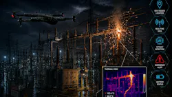
When an electricity grid emergency strikes after dark, the first challenge utilities face often isn't repair; it's detection. Where exactly did the fault occur—a power cutout, a missing or damaged component, a spark, or another technical fault? Is it safe to approach? And which crews and equipment should be dispatched? Traditionally, answering these questions has meant sending crews out to physically locate and inspect the problem, a process that takes valuable time precisely when fast decisions matter most. Darkness, difficult terrain, energized equipment, and blocked access roads can all delay this manual assessment even though ground patrols remain an essential part of the response.
This is where a new generation of AI-powered drones offers a smarter, faster alternative. Equipped with thermal imaging, high-resolution optical cameras, artificial intelligence (AI), geospatial positioning, and real-time communications, drones can rapidly scan the grid station to detect power cutouts, sparking, missing components, and other technical faults, pinpointing the exact location of the issue in a fraction of the time it would take a full crew to search manually. Rather than deploying personnel to survey wide areas of the power grid in the dark, utilities can send an AI-powered drone first to quickly identify the exact problem or technical issue, where and what it is.
That's where this drone flight data integrates with an AI-assisted analysis of the fault location and utility workflows that trigger a field response. The minutes crew members are currently wasting looking for the fault become ones they spend repairing it. The data from the first few minutes of the flight helps decision-makers dispatch the right team and the right equipment to fix a single component at a single point in the system, reducing risk to the crew while restoring power to a wider swath of your customers.
Why Nighttime Grid Emergencies Are Different
Daytime power grid inspections benefit from natural visibility. After dark, however, crews may need to evaluate infrastructure across the grid area or storm-damaged areas with limited visual information.
- A nighttime emergency may involve several questions at once:
- Where is the likely fault or damaged asset?
- Is vegetation contacting or obstructing infrastructure?
- Are components showing abnormal thermal behavior?
- Is the access route safe for a ground crew?
- Has a pole, crossarm, conductor or other structure been visibly damaged?
- Which location should restoration crews investigate first?
Have storms, strong winds, or earthquakes caused damage? - Where are electrical sparks or hotspots occurring?
Drones are not meant to replace utility field workers or existing protection, SCADA, outage-management, and inspection systems. Instead, they offer an additional mobile sensing platform one that can help connect an electrical and/or system-level alarm indicating an anomaly with visual and thermal field data. According to EPRI, artificial intelligence can enhance post-event damage assessments by incorporating near-real-time inputs and feeds from drones. The resulting reports and products can then inform restoration planning, as well as help determine the crews and resources needed to address the issue.
How Drone Technology Helps Manage Nighttime Power Grid Emergencies
During a nighttime power grid emergency, AI-powered drones can be deployed over the affected area to capture thermal and low-light imagery while geotagging damaged assets. AI-based computer vision then analyzes the incoming data to detect thermal anomalies, broken components, vegetation contact, or structural damage, assigning a priority level to each suspected fault. Validated findings can be shared with utility operators in near real time, helping them assess access conditions and dispatch the appropriate crews and equipment.
Technical Features Supporting Night Operations
Thermal Imaging
Thermal cameras offer one of the most significant sensing capabilities when compared to conventional RGB cameras because they rely on thermal energy, not on visible light. In some situations, thermal imaging can assist inspection teams in detecting abnormal temperatures around electrical components or appliances such as connectors, switches, transformers, etc., depending on the asset and operating condition.
Thermal results do not necessarily indicate failure. Load conditions, weather, emissivity, viewing angle, distance, and other variables affect thermal measurements. The information needs to be interpreted by qualified utility staff within the proper electrical and operational context.
High-Resolution and Low-Light Imaging
Thermal data alone isn't always enough. Utilities often also need visual evidence of broken components, vegetation interference, structural damage, or other physical conditions. High-resolution 4k cameras, optical zoom, and low-light imaging can complement thermal sensors to fill this gap. Together, visual and thermal data give a more complete picture than either sensor alone.
Modern power grid inspection drones illustrate how multiple sensing technologies can be brought together for aerial utility inspection, including optical imaging, thermal sensing, and georeferenced data collection.
AI-Assisted Detection and Prioritization
Drones can produce hundreds or even thousands of still photos or videos each. In an emergency scenario, producing more data still goes to waste unless utilities are able to translate that data into actionable information. Computer-vision and AI systems can play a supporting role by sifting the images for pre-set conditions, flagging segments for closer observation, and cataloguing observations by geography or asset.
Important word: assist.
Automated detections from AI shouldn’t on their own declare the health status of energized components nor automatically initiate switching or repair. Human judgment is still required. In the more practical emergency response mode, the picture looks like this:
Detect → flag → geolocate → validate → prioritize → dispatch.
This approach treats AI as an information-filtering tool rather than a substitute for engineering judgment.
Geospatial Mapping and Asset Referencing
The usefulness of emergency imagery increases greatly where each observation is related to a specific pole or structure or span or substation component or geographic coordinate. Utilizing GNSS positioning, GIS integration and geotagged imagery can aid utilities to link up aerial observations with existing asset records. An inspection team can pinpoint the location of a problem for further investigation rather than report it as being “somewhere along the circuit.”
Records that are repeated over time can also be used for pre- and post-event comparisons of geospatial data.
Remote and Repeatable Flight Operations
UAS programs can be more repeatable using preplanned flight routes, autonomous navigation, and increasingly capable remote-operation systems. Repeatability is important in emergency response. A reconnaissance flight may be necessary, followed by a more detailed look once conditions have returned to normal, then another flight following repairs to record the return of the asset.
Where regulations, communications, weather, and utility procedures allow, drone docking and remote deployment systems could further minimize the time between an incident and initial aerial assessment. EPRI is currently investigating utility UAS applications including distribution patrols, transmission inspections, substation inspection and night operations, and cutting-edge technologies like docking systems.
Operational Benefits for Utilities
- Faster Initial Situational Awareness: AI-powered drones can rapidly survey the grid at night, transmitting visual and thermal data to utility teams in real time. This capability helps reduce uncertainty during the early stages of an emergency and gives operators a clearer picture of overall grid conditions.
- Reduced Exposure to Hazardous Inspection Conditions: Aerial reconnaissance of the grid can provide an initial assessment of energized infrastructure, damaged equipment, unstable structures, and unsafe conditions before personnel approach potentially hazardous locations.
- Better Crew and Equipment Prioritization: Drone data can help identify the location, type, and apparent extent of damage, enabling dispatchers to determine whether line workers, vegetation, power station grid crews, specialized equipment, or additional inspection resources are required.
- Improved Thermal Awareness After Dark: Thermal sensors can reveal temperature differences that may be difficult to identify with conventional nighttime imagery. With electrical data, these observations can help prioritize further investigation.
- Better Documentation for Post-Event Analysis: Geotagged imagery, thermal drone camera records, and flight logs create a digital record of asset conditions that can support engineering reviews, maintenance planning, event documentation, future inspections, and validated AI-based analysis.
From Drone Detection to Crew Action
The best utility UAS program is not a stand-alone aviation program. Should interface with systems and staff currently involved with grid operations. A well-developed workflow may start when an outage-management system, SCADA alert, or customer reports or field personnel detect a possible problem. A competent UAS team could then be deployed to gather the optical and thermal data from the impacted area.
Computer software that uses artificial intelligence (AI) could identify observations that need to be reviewed. These results would be confirmed by qualified staff and linked to a GIS or Asset Management database. Combined, the information would enable operations personnel to prioritize field response.
In other words, the goal is not:
Drone → image.
It is:
Incident → aerial data → analysis → human validation → operational decision → crew action.
That distinction determines whether a drone remains primarily an imaging tool or becomes part of a broader emergency-response system.
Practical Limitations Cannot Be Ignored
Weather could actually be the reason why a flight cannot be made safely just when storm damage is most severe. Weather such as high winds, precipitation, icing, smoke, and poor visibility can limit UAS operations. Battery life and communications range are also mission-limiting factors.
Cybersecurity is a challenge for utilities, too. The imagery from the grid, geographic coordinates, infrastructure condition data, and live video may include sensitive information. Therefore, secure communication, access controls, data retention policies, and appropriate system integration should be included in the UAS architecture.
Lastly, AI should not be considered an independent engineering decision maker. Misreading or false alarms and varying environmental conditions are still possible. There must be established procedures within utilities for human review, escalation, and verification.
Building a Nighttime UAS Response Program
Utilities considering nighttime emergency drone operations can begin with a narrow, measurable use case rather than attempting full automation.
A practical program can define:
- which emergency conditions justify UAS deployment;
- which sensors are required for each mission;
- who is authorized to review thermal and AI-generated findings;
- how drone observations enter GIS, outage-management or asset-management workflows;
- what aviation, cybersecurity and data-governance controls apply; and
- how performance will be measured against existing inspection methods.
Metrics might include time to first assessment, time to locate damaged assets, number of unnecessary field inspections avoided, crew exposure hours, data-processing time and restoration-support outcomes.
These measurements are important because the business case for emergency-response drones should be based on operational results rather than the novelty of the aircraft.
The Next Step: Turning Nighttime Visibility Into Action
If there's a need to see more through smoke and dust; over obstacles where access is a challenge; under time pressure, drones offer utilities a new pair of eyes. But these flying eyes likely will offer the greatest value not by displacing line workers, engineers or grid-monitoring equipment, but by helping those people get to field intelligence more effectively and more quickly. Adding thermal imaging penetrates visible-light barriers.
Powerful cameras capture physical condition.
And AI-powered platforms can help organize vast amounts of visual data, while geospatial platforms can help tether such observations to specific utility assets. Remotely piloted operations can also extend the reach of field personnel. Together, in practice, they can compress the time from spotting an issue to dispatching a crew that has actionable knowledge.
For any utility, THAT may be the most effective metric for a grid-focused drone effort-not the drone's capabilities but its contribution to a more reliable, efficient, and confident response when the system fails.
AI-powered drone technology combining thermal-camera imaging and intelligent analytics can make nighttime grid monitoring and inspection faster, safer, & more accurate by detecting faults, sparks, and emergency conditions while saving valuable crew time. Beyond grid stations and power-line inspections, drone technology is increasingly improving workflows worldwide across agriculture, smart cities, security, defense, construction, manufacturing, and other industries where rapid monitoring, inspection, and data-driven decisions are essential.
About the Author
Andrew Mabry
Andrew Mabry a technology researcher and analyst specializing in UAV and drone technology, artificial intelligence, machine learning, automation, and emerging digital technologies at ZenaDrone. research examines how these technologies are developed, applied, and adopted across industries worldwide, with a focus on real-world applications, innovation, and evolving industry trends.