Mobile App Leverages Connected Data through Geospatial Intelligence
The value of data is no longer in question. In 2017, The Economist decreed that "the world's most valuable resource is no longer oil, but data," and since then, discussion has raged around identifying ways in which this new data economy can offer long-term benefits.
Today, this focus is evolving — shifting away from the data itself toward how the data relates to itself. Understanding the relationships between connected data can offer deeper — and more powerful — insights. Armed with enough data points, organizations can use analytics to understand the context, allowing them to identify patterns and even make predictions about the future.
Emerging technologies, specifically graph-based data technologies, work to describe and illustrate this connectivity. Graph technologies display the relationships between data, allowing users to visualize the relationships between the data more easily. In a world of networked systems, it's a nascent field in the industry and one where utilities are just starting to scratch the surface.
Benefits of Geospatial AI Technology
Geospatial artificial intelligence (AI) is an emerging field, defined loosely as understanding the physical world at scale using AI to drive meaningful insights. Geospatial AI maintains connectivity and relationships between data and the real-world, and when paired with graph technologies, can offer unprecedented improvements in situational awareness in dynamic environments.
Marrying passive geospatial data collection with AI can enable advanced field ops capabilities like change detection, where AI would automatically detect changes within a specific time frame, for example, from yesterday to today. If a storm rolled through overnight, utilities — armed with geospatial AI technology — could quickly and easily take stock of the critical components of their infrastructure. The system would use deep learning models to flag the change and use workflows to send an automatic notification to field crews via a mobile device, such as cell phones or tablets. Enabling these systems would offer far more targeted data; out of 24 hours of data, the system might only flag 10 minutes that would be worth analyzing.
Traditionally, utilities invested in active data collection to gather the information they needed. Today, they can benefit from passive data collection that could be as simple as installing dashboard cameras on field ops trucks. The crew would drive its assigned route, automatically collecting data without human action. This passive data collection could even be scaled up to work with delivery fleets such as Amazon, FedEx, UPS, and the U.S. Postal Service, which have unprecedented access to neighborhoods and communities over predictable routes. By installing sensors and cameras on these vehicles, utilities could obtain what is essentially a daily snapshot of the entire grid. Repeated data sets over periods of time could allow utilities to understand temporal changes to infrastructure and environment, further enriching the analysis.
Use of active data collection and AI analysis would offer several benefits to field crews. By providing a preview of the area, infrastructure, and assets, this approach would enable smarter and more targeted pre-job planning long before field crews even arrive on the scene. Providing the full snapshot ahead of time would also allow for advanced site selection. Lastly, this type of geospatial intelligence could help optimize the logistics behind field planning (for example, by optimizing the routing between multiple job sites) to help crews focus on the task at hand.
Case Study: BV Safe Contact App
The foundations of geospatial AI technology are already in practice. In 2020, Black & Veatch introduced its BV Safe Contact app, a geospatial tracking tool designed to help safeguard distributed field teams during COVID-19. With the COVID-19 pandemic making core infrastructure services such as power, water, and telecommunications more critical than ever, the tool combines live health and safety data with real-time mapping technology to continuously monitor potential exposure and health threats, helping to protect field service workers and line construction crews.
To do this, BV Safe Contact streams active COVID-19 case data directly from Johns Hopkins University and links it to active client project locations to provide a real-time view into active hotspots and potential high-risk areas. This allows Black & Veatch and its clients to make informed decisions on where to allocate field services resources, allowing them to relocate crews and project efforts to safer, less-affected areas while avoiding critical service disruptions.
The app relies on Black & Veatch's Nora, a cloud-native connected data platform deployed last year to better manage large-scale distributed infrastructure projects, and graph visualizations and analytics powered by Kineviz's GraphXR software. BV Safe Contact is currently being used by a large northeastern utility, which serves more than three million customers throughout the state of New York and New England, regions hit hard by COVID-19. The utility is using BV Safe Contact to make informed decisions on where to schedule project work and relocate workers.
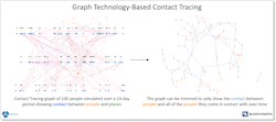
For example, if Tom, Dick, and Sue were all at the same job site and then traveled to another job site the next day, the platform retains that knowledge and can trace them throughout their locations. If Tom later reports that he is infected, the tool can run an advanced analysis that reconfigures the entire network to focus solely on Tom and the people and places he came in contact with, and then send an automatic alert about potential exposure (Fig. 1).
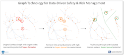
This approach takes contact tracing to another level by enriching it in terms of worker safety and risk management. By understanding how the network of people, places, and their interactions are connected, we can quickly identify high-risk field crews who may encounter a lot of people.
Conversely, a field crew manager may only have direct contact with a small number of people, but that group may touch the whole team, thus, identifying that field crew manager as a potential "super-spreader" (Fig. 2). Employing additional PPE measures or adding another crew manager may help to prevent a potential super-spread to the whole team.
BV Safe Contact offers a three-dimensional view of how people and projects are interconnected, but this same approach can be applied across applications to deepen the understanding of connected data.
Looking Ahead
Although still an emerging technology, geospatial AI can offer field ops crews great benefits once they shift their focus toward understanding and incorporating the relationships between the data. Geospatial AI could even be integrated into other tools such as wearable devices. For example, RealWear's HMT-1 is a head-mounted, voice-controlled, and LTE-connected device that features a camera and screen. The HMT-1 can be connected to a distributed workforce platform such as Microsoft Teams, enabling a direct line of communication with the back office. A first-line technician could livestream a video call with a remote engineer to help troubleshoot and resolve an issue. By digitizing these operations, the technology breaks down the barrier between field and office, extending and enhancing the field team's capabilities.
If geospatial AI was integrated into this device, it could be used to alert field staff to physical dangers, such as sending out a notification if the operator got too close to a dangerous area. Or if the operator walked by a control box, it could automatically display schematics on the video screen.
The dramatic reduction in cost and maturity of 3D scanning technology allows for the real opportunity to create immersive 3D digital twins. Accelerated by the early adoption by the real estate business, the technology can be leveraged to benefit field crews, for example, by capturing hyper-realistic visual data within substations and facilities. The raw data can also be exported into a platform like AutoCAD to create detailed floor plans and layouts.
Although the technology is currently focused on reconstructing physical spaces, it could be expanded to pair with change detection technology, where the system would automatically send a notification if the physical space changed in any way.
To truly deploy systems at scale, utilities need to collect data as a baseline, input that data into graph technologies, and then use a machine learning model that is tuned based on certain inputs to pre-select candidate sites and different system configurations. Efficient use of connected data and geospatial AI can benefit field ops crews in myriad ways, enabling safer, more targeted, efficient operations.
To learn more about BV Safe Contact, email [email protected].
About the Author
Edward A. Sutton III
Edward A. Sutton III, P.E., is a program manager and systems architect for Black & Veatch. With a background rooted in critical infrastructure, he has thorough experience in leading — from concept to completion — a wide array of complex emerging technology projects. He works to develop whole system solutions to complex problems focused on modernization and digital services.


