What exactly are the responsibilities of the utility company?
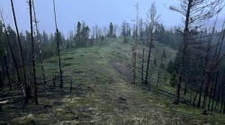
Wildfire season has begun earlier than ever before. With Texas now facing its worst wildfire to date, and scientists calculating 90% of Hawaii is getting less rainfall than it did a century ago, utilities must prepare to operate in an environment where climate change poses an inherent risk to their vegetation management strategy. In Part 1, there was discussion about PG&E incorporating at-a-glance visual data technology across thousands of miles of its transmission lines in the High Fire-Threat Districts. Areas where the fire risk continues to increase year-on-year.
Mitigating Wildfire Challenges
For context, the job of mitigating wildfire has never been easy, but today it is more difficult than ever. Utilities allocate substantial resources to manage vegetation, manually trimming back foliage that poses a risk of ignition upon contact with power lines or could damage assets in high winds. Climate change and changing weather patterns make what was already a difficult task into a much more complex one.
In practice, this means that utilities must dispatch teams to manually inspect their assets for signs of wear and weakness. If they find issues that must be rectified, they will then report back, and a workorder will be issued for a repair team to go out and fix the issue based on urgency and severity.
Vegetation Management
In parallel, if there are concerns over vegetation encroachment, an arborist team will be sent out to inspect, then report back with a quote to cut back to specifications. That initial pre-inspection can cost as much as $800 per mile, not even factoring in the cost of the actual work order.
Two sets of specialist teams are sent to perform manual inspections on the assets themselves and the vegetation that surrounds them; followed by separate follow-ups to rectify any issues identified. This requires a lot of work, and a lot of expense.
And that’s not all – this is compounded by the fact that utility maps of their assets are frequently wildly inaccurate. We have seen areas where utilities have underestimated the number of poles they have in an area, and have mapped their locations dozens, if not hundreds of yards out of sync with reality.
This isn’t as surprising as it may seem, though. Remember that some of these assets date back to the 1800s, that paper records get lost, and that it’s very easy for discrepancies of any size between designs and as-built to creep into any project.
This introduces huge inefficiencies into the process of inspecting and maintaining the network effectively. There are instances where work crews are dispatched to the wrong location or find the job very different to their scope of work once they get there. In the worst-case scenario, assets that have fallen off the map may be under-inspected and maintained. Under the threat of climate change, utilities cannot afford to take this risk, that’s why our recent work with PG&E utilizes a new approach.
Integrating Technology for Enhanced Efficiency
Traditional manual and aerial inspection methods are hampered by their limited scope, range, and the finite resources of human inspectors, making it difficult for utilities to keep pace with the rapidly evolving climate threat.
Living Digital Twin
This is where the latest technology innovations come into play, greatly enhancing vegetation management efficiency for utilities such as PG&E. Using Living Digital Twins, enhanced by machine learning algorithms, allows data sources such as weather reports, aerial vehicle data, network events, and field observations to be visualised together in one platform. The system continually updates as new data is added, blending these insights into a risk assessment model that helps prioritize preventive measures in real time.
For utilities, this approach means incorporating geological, ecological, and meteorological data collected from air vehicles like satellites, drones, and sensors. When combined with grid maps, this information helps model and mitigate future extreme weather scenarios. For instance, data indicating warmer weather due to climate change can be aligned with information on winds to forecast areas where wind might carry sparks to dry vegetation, posing a wildfire risk.
Light Detection and Ranging (LiDAR)
A significant tool in this technology stack is LiDAR, which generates a geospatial point cloud to map objects in 3D, identifying the proximity and dimensions of vegetation relative to power lines. Augmenting this with RGB (red, green, blue) imaging data introduces color and detail to the point cloud. The addition of hyperspectral imagery, which detects parts of the electromagnetic spectrum invisible to the human eye, offers an extra level of detail. This combination allows for the identification of different vegetation species by analyzing how they reflect sunlight at various wavelengths, providing data with higher fidelity than traditional human observation.
By integrating these three data sets—LiDAR, RGB imaging, and hyperspectral imagery—utilities such as PG&E gain a comprehensive geospatial understanding of where
vegetation is in relation to power lines, what that vegetation is, and how it might interact with the infrastructure. This wealth of information is crucial for informed decision-making in vegetation management.
Navigating Risk and Reward
There are more than 200,000 miles of high-voltage transmission lines across the US. It is a truly herculean task to stay on top of, and utility resources are not infinite. Utilities must strike a balance between responsible operations, profitability, and respect for the ratepayer.
Any tension between these stakeholders evaporates when the worst comes to pass. Shareholders and executives who have an incentive to prefer lower operational expenditure are not well-served by hits to the share price and regulatory fines. Ratepayers also don’t want high operational expenditure reflected in their bills, but those bills rarely get lower in the wake of disaster – repairs must be paid for, and FEMA’s funds may be running low.
Ultimately, wildfire risk is business risk, and utilities must do whatever they can to mitigate it. But for shareholders, ratepayers and – crucially – the communities affected, it’s worth it.
James Conlin is a product manager for Sharper Shape Group Inc. He joined the company in 2019, participating in some of the world's largest UAV operations, and quickly progressed to become a valued member of the project management team, where he oversaw the planning of operations.