Remediation Tools

In addition to safety benefits, by incorporating the data more efficiently and using an automated process, we estimate the opportunity to result in $8 million in savings, including approximately 170,000 worker hours, if applied to SCE’s entire service area.

Of those that were surveyed, none had developed novel automated solutions. Considering this research, the technical working group partnered with SCE’s Information Technology team to devise a solution, bringing together various groups with expertise in artificial intelligence (AI), geospatial analytics, image recognition, machine learning (ML), optical character recognition techniques and statistical methods.
The Solution

DaaS enables visualization, analytics and AI/ML models execution with easy consumption, fast performance and high reliability. Simply put, DaaS has the same effect on big data that monetary currency had on bartering goods and services — DaaS allows for easy data interoperability across different software applications.With this powerful tool, the team built and trained advanced ML models to recognize key objects or features contained in photos, enabling them to perform a range of innovative functions, such as:
- Accurately associating photos with their corresponding real-world coordinates to derive a structure’s true GPS location.
- Effectively analyzing many photos captured from different time, devices, programs using geospatial analysis.
- Analyzing multiple factors, including number of photos, capture time of photos, statistical significance of data distribution (mean, standard deviation, outliers),
validation among multiple sources, etc.

Human effort is needed for only a small percentage of assets the tool cannot validate with confidence. Even then, the remediation tool’s visualization feature streamlines the effort. As an example, any asset with a nadir image (the vantage point looking directly down on the top of a structural asset) has a high confidence latitude/longitude coordinate value.
Improved User Experience

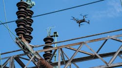
As the team continues to expand and test this approach, it has promising asset data management applications for the entire industry.Photo courtesy of Southern California Edison.When more research is necessary, the team can efficiently confirm their findings by accessing this central repository of photographic evidence, enabling them to reach a prompt and informed conclusion. On a massive scale, the data remediation tool solves a similar problem that today’s television viewers experience navigating video content across dozens of content providers on their Roku or Apple TV. Just as these digital media players’ algorithms sift through user data to extrapolate and suggest shows the user might like, the remediation tool similarly sifts through utility photo data to predict equipment location.