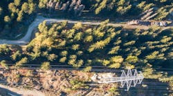
Vegetation managers are all too familiar with the challenges that overgrown trees can present around electrical transmission lines. A tree that is too close to transmission lines or tall enough to fall onto them can cause an outage and even spark a fire. Monitoring these hazards is especially difficult when field crews are responsible for managing large work areas.
Ryan Blothenburg, Western Division Transmission Line Forester for National Grid, encountered these challenges in his work. Blothenburg manages the western third of New York state, which includes roughly 2,800 circuit miles of transmission line over an 8,400-square-mile area.
Any time a problem occurred for National Grid in western New York, such a momentary outage, a field crew would have to patrol hundreds of miles of transmission lines, potentially delaying mitigation. Ground patrols included personnel on foot and riding ATVs as well as helicopters used to survey the corridor. In some cases, field crews would wind up in wetlands or other difficult-to-navigate terrain.
National Grid needed a way to view corridors and pinpoint the location of a possible outage before one might occur. Furthermore, they needed a more efficient way to send crews out into the field when mitigation is required. The faster that crews can reach the origin of an outage and determine the cause, the faster they can restore power for customers.
Blothenburg and his team began using TreeRisk™ from EagleView on 350 miles of corridor to find problem areas remotely. TreeRisk helps vegetation managers pinpoint encroachment risks and confidently take action to mitigate them. With a web-based platform, up-to-date orthogonal and oblique aerial imagery, and complete datasets, TreeRisk enables users to share highly accurate maps to reduce field time and decrease mitigation expenses.
“The biggest challenge in vegetation management is that… trees are always growing,” Blothenburg said. “It’s not a static environment that we work in, so it’s very important to establish lead times on potential problem areas. That’s where TreeRisk really shines.”
Learn more about how National Grid received a comprehensive view of the corridor and a clear path to answers with TreeRisk.
Sponsored By: