And we’re back! If you missed my post last month, please check out The Future of GIS – Part 1, In a Relationship where I explored three different types of GIS relationships that drive immediate value in a utility or telco. The relationship types include database relationships, spatial relationships and network relationships, all of which are crucial to setting the stage for the future.
This month I’ll continue to review where a utility should be with GIS today before exploring where you should be focused to maximize your investment in GIS in the future. As a utility or telco matures with its relationships, it will begin to relate outward.
Whenever I am speaking with utilities, I often challenge them to find any piece of data within their organization that CANNOT be spatially represented within a GIS. We’re talking customer data, work order data, inspection data, asset data, vehicle data, monitoring data, etc.
And as that data is presented in a geospatial context, we can create new relationships that may not have been apparent or even possible without the GIS. As we discussed last month, relationships fuel decision-making and therefore GIS systems integration fuels exponential decision-making throughout a utility by relating disparate data points.
Many of you will have already embarked on systems integration between your GIS and other systems within your organization. Every customer has slightly different priorities and there’s no right or wrong when it comes to these integration points.
Over time I have worked with enough customers to establish some common themes based on implementations I’ve seen which are worth sharing here. I’d be interested in any feedback on which of these systems you have integrated to and perhaps which others you may have touched that are not listed.
Like any long-term geo-geek pulling his weight in the industry, I usually talk about the GIS being at the center of the universe. I know plenty of folks who may have other thoughts, but we will agree to disagree!
With that said here are the most common system integration points I’ve seen:
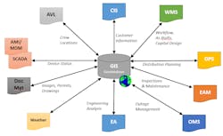
Customer Information System (CIS) – this is perhaps the most common integration point, as all of our utility and telecom clients are in turn servicing their own end customers that consume some form of energy or data services from them. This may be as simple as automating a load of customer meters or service points from the CIS into the GIS but can also be much more extensive. A lot of utilities push coordinate data from GIS back to CIS and others that pull additional usage data (monthly and/or peak usage) from CIS into GIS to fuel other analysis. No matter what level of data you integrate, it will absolutely add significant value. We are also forecasting a tremendous uptick in CIS integration as customers continue to add personal renewable generation points as well as behind the meter smart home devices that interact with energy. This creates a challenge but also an opportunity for us to consume and expose this data geospatially to other systems throughout the utility.
Work Management System (WMS) – this is probably number two on my list, but it’s a close second to the CIS. Work management systems track work as it is designed, approved and subsequently completed at a utility/telco. All of these phases of work can be tied into a GIS. Many utilities perform graphic work designs within GIS that drive material ordering and costing of the job, visualizing the workflow of the assets in the system (design, approved, in construction, etc.) and finally, capturing the as-built details of the job into GIS at the completion of the work. If you don’t have these systems integrated, I can almost predict that you are performing duplicate data entry at some point in the process which introduces errors and omissions. The speed with which we process field network changes into our GIS directly affects almost every other system and process within the utility and clearly affects the safety, reliability, and efficiency of utility operations.
Distribution Planning (DPS) – there are a number of DPS applications out there that will assist utilities in planning for expanding their energy distribution to new customers based on projected demands. Most of these systems can accept your current utility network into their system via an ETL (extract, transform, load) process. This is a key integration utilities must perform to export your authoritative network data from your GIS into these external systems on a regular or on-demand basis. The target data formats can vary, but your Esri GIS often has all of the detail required.
Enterprise Asset Management (EAM) – there are a lot of details managed in an EAM surrounding the assets owned by your organization. A TON of value can be added by automating the process of adding and retiring assets in EAM based on the editing actions taken within GIS tied back to your as-built entry process. This is often a round trip integration that allows the asset records in GIS to be tied to the EAM asset records. A utility can then drive inspection and maintenance events in EAM based on spatial relevance such as inspection grids, service territories, etc. Enabling EAM processes with geospatial drivers will always increase efficiency.
Outage Management System (OMS) – some of you may run your OMS directly on top of your GIS data but for those that don’t, you will most often want to feed your network data from GIS into that external OMS. Similar to a DPS, this is often accomplished using an ETL process that will consume your utility or telco network to drive a scheduled or on-demand import into the external OMS. Many OMS applications also now support the concept of incremental updates where utilities send regular updates from the GIS into OMS based at the circuit or utility system level as opposed to extracting the entire network during each push. OMS apps usually require a high level of quality in your GIS which ties back to your data maintenance procedures and the relationships that we discussed last month.
Engineering Analysis (EA) – engineering analysis tools allow you to design facilities based on asset-based and external factors. This often includes pole loading, secondary transformer loading, cable pulling or any number of engineering functions. There are applications out there that specialize in these and many others that can be fueled with your GIS data as an input to represent the current as-built asset data and/or newly designed data.
Weather – while this may seem obvious, not enough utilities are using real-time weather data within their GIS. Weather data is now readily available via web services from a number of companies in native Esri formats. This data can be overlaid on top of your GIS assets to present a new view of how weather may affect your network, your customers and your operations.This can be used in assessing ongoing storms or even for forecasting weather patterns against your service territory.
Document Management – document management systems usually allow you to add, index and search documents of any type based on stored metadata about the document or its content. We’ve built some pretty cool document management integrations that use GIS features or their spatial locations to drive automatic searching of documents. This really adds value when you have located an asset or address in GIS and want to view all documents related to that location.We can often use the attribution in GIS to automatically locate and display the related documents directly in the GIS (desktop or web). This provides a whole new pattern for locating your docs.
SCADA & AMI/MDM – these systems are all about real time monitoring of assets in the field. They can send event notifications to the GIS to represent meter status or connectivity which we can use to display to users on a map, driving all types of decisions. One utility allowed GIS users to query an AMI system to get the real-time status of one or more selected meters in their GIS. Meters and devices are typically already on a utility’s maps, so why not consume their status to enable other spatial processes!? Beyond status, we’re also seeing a general uptick in consuming other monitoring information in GIS. In another example, we were able to consume voltage alarms from AMI meters and subsequently tie them back spatially and through the GIS network to predictively determine transformers that needed to be inspected or even replaced. All before the customer ever knew there was a problem!
Automatic Vehicle Location (AVL) – all utilities have mobile workforces that dispatch various types of trucks and other equipment to service the assets in the field. Many of them have now moved toward adding AVL tracking to their fleets which allows for GPS coordinates to be transmitted at regular intervals to the back office.A typical AVL integration allows that data to be made available in GIS to show crew or other staff locations in real time with relation to our assets/network. This can drive a lot of processes by determining which crews are closest to incidents or assets, which crews are currently en route and which are already onsite. It’s a whole new level of real-time data.
As mentioned above, this isn’t meant to be an exhaustive list but does represent a common theme that I’ve seen among many utilities. Let me know what other systems you have integrated to and if you haven’t hit one of these systems, perhaps this will give you some new ideas.
All of the above integrations are still what I would consider “traditional GIS.” Most of these patterns have been around for 15 years or more with one key difference. Back in 2000, only the largest utilities could afford these enterprise integrations whereas now we see cooperatives, municipalities and other smaller utilities achieving significant return on investment through these same patterns (for a whole lot less dough).
The bottom line is that there absolutely is value to be realized if you haven’t looked at any of these areas within your organization!
This wraps up part two as well as my high-level assessment of where you should be with your GIS today. All of these relationships and integrations are not necessary to embrace the future of GIS, but they can absolutely drive its success.
Next month I’ll dive right into where we’re headed as an industry and how you can embrace that change!
SSP Innovations is an official T&D World media partner.


