In recent years, North Dakota, U.S., has witnessed a boom and bust in oil production. The landscape is now dotted with idle drilling rigs waiting for an uptick in oil prices to begin working again. While the future of oil is uncertain, another industry in North Dakota is increasingly bringing economic development and national recognition to the state. A New York Times headline recently dubbed North Dakota the “Silicon Valley of Drones,” because it is home to an impressive effort to advance the commercial use of unmanned aircraft systems (UASs).
The utility industry is among the business sectors developing UAS research in North Dakota. In July 2016, Xcel Energy began working with the state of North Dakota and a group of partners on a yearlong research project. The objective of the project is to test various UAS capabilities and determine how to use UAS technology to assess damage to utility infrastructure after natural disasters, such as tornadoes, floods or storms. The project is expected to demonstrate the value of drones when disaster strikes to enhance safety, reduce outage restoration times and provide overall delivery operational
excellence to disaster recovery.
Headquartered in Minneapolis, Minnesota, U.S., Xcel Energy received a state grant from Research North Dakota (Research ND) to conduct the research. Although more than a dozen utilities have tested UASs in the past few years, the Xcel Energy-led research is unique because it will use both a small low-altitude drone and a large high-altitude drone to collect data. Using the large drone has the potential to make UASs far more valuable for data collection, as it can remain airborne for several hours longer and survey thousands more miles compared to a smaller drone.
A Research Partnership
The US$1 million research project involves a partnership with Xcel Energy, the University of North Dakota, Elbit Systems of America, Centers of Excellence Commission, General Electric and others. Through Research ND, the North Dakota Department of Commerce is providing $500,000 for the effort, and Xcel Energy and the other partners will provide matching funds of $500,000.
Overall, the goal is to develop and commercialize damage-assessment processes that improve storm disaster response times using UASs. Additional research objectives are to assess high- and low-altitude UAS capabilities to enhance restoration; develop a UAS natural disaster strategy in collaboration with emergency management leaders; apply UAS capabilities to support reconnaissance of distribution infrastructure; and identify a process to use UASs for disaster reconnaissance as well as restoration efforts.
The research is based in Mayville, North Dakota, a location that makes the project unique because the UAS will fly over a community. When the research was being planned, the U.S. Federal Aviation Administration (FAA) did not allow drones to fly over populated areas.
Research Flight Plans
During several test flights, Xcel Energy and its partners will simulate natural disaster scenarios. The team will use a large UAS and a small UAS to assess the area. Utility poles will be placed on the ground to test whether the UASs can locate them within a community. Both UASs will gather data on the post-storm condition of utility infrastructure by searching for downed utility poles as well as conductor and substation damage.
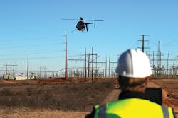
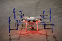
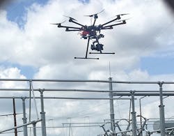
The research team will deploy a small UAS that resembles a small helicopter, weighing less than 55 lb (25 kg), and can fly for up to an hour. Compared to the larger drone, the small UAS can fly closer to utility infrastructure to provide greater image resolution.
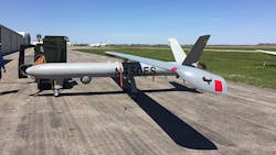
Elbit Systems of America will operate the large high-altitude UAS, a Hermes 450, which is a fixed-wing unmanned aircraft with a 35-ft (10.7-m) wingspan. It can fly at altitudes from the surface up to 10,000 ft (3048 m). Compared to the smaller drone, the greatest advantage of the large UAS is its ability to remain in flight for up to 17 hours. It can inspect up to 25,000 acres (10,117 hectares) per hour.
Both UASs are equipped with multiple sensors, cameras, and light detection and ranging (LiDAR) technology. The research team plans to send live streaming video from the UAS in North Dakota to the Xcel Energy control center in Minneapolis. Data from the UAS will be compared to determine which one provides the best data and under what circumstances. It could be possible both are needed to perform a complete damage assessment.
In addition, if proper approvals are secured during the yearlong project, the research team will fly the large drone in challenging weather conditions and at night. Using a UAS in windy conditions or at night would help to speed damage assessment after a storm. Instead of waiting for daylight or waiting for the storm to pass, the Hermes 450 could fly in behind the storm.
Because it is large enough to be equipped with lights, the Hermes 450 already is being flown at night outside of the U.S. Several other countries with fewer UAS flight restrictions have been using the technology more extensively. The research team in North Dakota will be developing a concept of operations so Xcel Energy and its partners can make a case to regulators to allow a variety of UAS flights during their
research.
Actionable Data
While a UAS has tremendous potential, it also presents several challenges. A UAS equipped with sensors provides an overwhelming amount of data. This could be a problem when faced with an urgent need to analyze information quickly to make critical decisions for storm recovery and power restoration. Damage assessments should inform a utility quickly about what materials and equipment need to be ordered, how many crews need to be dispatched and to which locations.
During upcoming months, the research team aims to integrate UAS data into Xcel Energy’s back-of-house systems. The data will be most valuable when it is in the geographic information and mapping system as well as the outage restoration system. This will enable Xcel Energy to receive UAS data that is intelligent and actionable in a timely manner.
Additionally, the research team will be working to ensure UAS procedures can be replicated and applied to a variety of outage scenarios. The program aims to produce consistent results with reliable data. The team will develop flight plan operations, a process for analyzing data and a variety of operational procedures.
UASs at Xcel
The Xcel Energy research team will benefit from previous years of drone experience at the utility. Xcel Energy operates and inspects 320,000 miles (515,000 km) of electricity and natural gas infrastructure, well over 1000 substations and dozens of power plants across its eight-state operations service territory: Colorado, Michigan, Minnesota, New Mexico, North Dakota, South Dakota, Texas and Wisconsin. UASs have the potential to assist in these inspections as well as for other uses to enhance public and worker safety, improve reliability for customers and deliver efficiency gains.
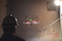
The utility has been advancing its UAS expertise and leadership since 2013, when drones began working inside the utility’s electric generating plants. The team has flown drones inside of boilers, heat-recovery steam generators, scrubber modules and other components. Drones even have been used to locate components stacked high in a plant warehouse. The price of a small drone — about $1500 — is economical compared with the cost of erecting scaffolding to conduct a boiler inspection.
Recently, at the Sherburne County Generating Station in Becker, Minnesota, drone flights inspected the Unit 2 burners. The information gathered resulted in a decrease in the number of burner parts that needed to be ordered. Guidelines and training have been established to foster safe and effective use of indoor UASs.
While indoor drones are now part of routine plant assessments, using UASs outdoors for commercial purposes is restricted under FAA regulations. When the FAA began allowing the commercial use of drones, it granted exemptions that required drones to be operated within the operator’s line of sight and within 200 ft (61 m) of the ground. In May 2015, Xcel Energy received the necessary FAA permissions to fly, and subsequent flights have provided valuable data.
Proof of Concept
During a variety of research flights, Xcel Energy has used drones to assess numerous facilities, including substations, transmission lines, gas pipelines, ash piles, wind turbines and indoor locations at power plants. The utility flew seven proof-of-concept flights in 2015. Following are a few examples of these flights:
- At an ash storage facility near Red Wing, Minnesota, a UAS equipped with a camera needed just 11 minutes to generate a 3-D rendering of the landfill to certify the ash volume at the 42-acre (17-hectare) site.
- At the Grand Meadow Wind Farm in Dexter, Minnesota, a UAS inspected wind turbine blades, lighting protection coatings and protective gel coat paint. The drone flight was conducted in 30 minutes and greatly reduced the amount of time the turbine was shut down compared to traditional inspection methods, such as sending crew members onto the blades with ropes.
- In western and southwestern Colorado, a UAS inspected exposed gas pipeline. The drone was equipped with a gas leak detection sensor to determine whether it could detect a simulated gas leak. It evaluated vegetation encroachment and the condition of the pipe.
Beyond of Line of Sight
In February 2016, Xcel Energy became the first utility in the U.S. to receive beyond-line-of-sight approval from the FAA for use of UASs on transmission lines. The research flights assessed 20 miles (32 km) of 69-kV transmission line northwest of Amarillo, Texas, in the state’s panhandle. Xcel Energy’s transmission line performance team was impressed by the ability to make significant improvements in data quality and data gathering through the use of UASs.
Xcel Energy has established a UAS program office to work with the utility’s operating areas on growing the use of UASs and delivering efficiency gains. Among other responsibilities, the UAS program office will develop the utility’s UAS policies and procedures, business cases and strategic plans. Internal policies require development and technologies to be streamlined, so the program office will work on an enterprisewide level.
Potential Benefits
It is estimated UASs could provide accurate storm-damage assessments in several hours rather than a day or longer as with traditional survey methods, such as deploying helicopters, fixed-wing aircraft, trucks or people on foot. That benefit is one of many reasons why the utility industry is investing in research to advance the commercial development of UASs. Xcel Energy and its partners in North Dakota will share their research with the utility industry. In addition, the Edison Electric Institute is conducting beyond-visual-line-of-sight research, which it intends to share industrywide. (Xcel Energy is a member of the Edison Electric Institute.)
UAS use has demonstrated its potential to create positive real-world changes in inspection, maintenance and storm response processes that will enhance safety and improve power restoration times.
Acknowledgements
The following organizations have been involved in the work documented in this article: Center for Innovation, City of Mayville ND, Elbit Systems of America, General Electric, Grand Forks Region Economic Development Corp., Northern Plains UAS Test Site, Research ND, and the University of North Dakota. Xcel Energy team members involved include Greg Bennett, Troy Browen, Christopher Clark, Michael Lamb, Al Lohman, Laura McCarten, Mark Nisbet, Judi Paukert, Gary Vaagene and Deb Watts.
Eileen Lockhart is the lead/manager of Xcel Energy’s unmanned aircraft system (UAS) program. She has been involved with the UAS program since its inception and has served as the program manager for the last two years. Under Lockhart’s leadership, the UAS team developed a governance framework, ensuring Xcel Energy is compliant with all federal and local regulations. Lockhart joined Xcel Energy in 2011 and represents Xcel Energy on the Edison Electric Institute unmanned aircraft systems team. She is also involved in the Electric Power Research Institute’s UAS-tailored collaboration project.
Sidebar: UAS in the Utility Industry
U.S. utilities are researching unmanned aircraft system (UAS) use and, in some cases, have already begun using them routinely. Following are a few examples of the activities for which UASs are being used or investigated:
- Power plant inspections. Drones are inspecting indoor areas, such as boilers, that are difficult to access. They fly in heat-recovery steam generators, scrubber modules, plant stacks and other components.
- Gas line inspections. UASs have been equipped with a sniffer to detect gas leaks.
- Assets in renewables. A UAS with an infrared camera can locate solar panels that are not functioning properly. UASs also are inspecting wind turbines.
- Disaster recovery. UASs could be used to locate downed utility poles, downed lines and damage to infrastructure. They also potentially could provide valuable data to determine what equipment, materials and personnel are needed for repairs.
- Transmission inspections. UASs inspect infrastructure to search for potential problems, check on construction progress and conduct security flights. They also potentially could deliver materials to crews.
- Ash waste sites. UASs verify the volume of ash at a landfill site.
